 ETTREMA WILDERNESS – 29 – 30 August 2020
Ever since 2018, when I first went out to the junction of the Ettrema and Jones Creek Trails, I’ve looked at the wheel rut tracks snaking off across the head of a tributary of Jones Creek, disappearing into hakea and heath and wondered if anyone ever went out on that long dis-used trail – supposedly it ended out near the massive waterfall on Jones Creek.
I’d heard from someone that the walk out to Jones Creek was “awful”, lots of scrub – ie don’t bother even attempting the walk. Interestingly though, since the fires, this is a popular route. One couple a month ago had walked it, on Saturday a couple were riding their mountain bikes along the track and on Sunday as we were walking out, three women were starting to go out to Jones Creek and camp the night … WTF? Where are all these people coming from, normally you go out to the Ettrema Plateau and you’re the only person (or group) there!
So, the back story about why we’re going out to Jones Creek on this occasion. In 2013, Jeff and I did a walk in Ettrema Gorge and mid-way through the trip, we headed up Jones Creek. Whereas in other years we’d done this as a bounce trip to check out the mine, this time we decided to continue to the 40m waterfall and as we were all feeling pretty strong, we decided to scramble up beside the waterfall, and proceed across to a plateau ridge and down a spur back to our campsite on Ettrema Creek. The trip report noted that “despite a little scrub the route was fairly straight forward”. I remember getting to the top of the waterfall (which in my memory was a rock slab in the creek) and stepping across the small trickle of water and then up the side of the waterfall and onto the plateau. Memory is a funny thing – highly unreliable – more about this later! So, here I am, back on the bloody Ettrema Trail (that in 2018 I’d vowed and declared I’d never walk again), and I’m back for the third time in as many months.

On Friday night, after our Boolijah walk, Steve and I met up with Heather (who’ll go anywhere with me) and Jeff. Murray and pregnant Emma would meet us the next morning. Heather brought her grill and we had a delicious rack of lamb dinner (thank you Heather).

Murray and Emma arrived and we set off at 8.15am. The line up for the walk wasn’t looking good, Heather had undergone knee replacement in May, Emma is 5 months pregnant and Jeff knocked his little toe on Friday morning, it may be broken. Good thing that Steve, Murray and I were able bodied.

Looking down the motor vehicle ruts in the direction we’d be heading. It took us about 3 hours to get to the turn off point (some strapping of Jeff’s little toe and a long morning tea took up about 30 min).

The track after the fires is very well defined, only a couple of sections where you couldn’t see any evidence because of mud in this case or when it went across rock slabs.

Crossing a rock slab.

Emma on the track, what other woman 5 months pregnant would be out there on a two day walk? She’s a legend AND she had some punctures in her Thermarest so spent a difficult night trying to get comfortable. (Photo: Murray)

Murray and I had agreed upon where we were going to drop into the creek … we got to this point and decided that it looked good so off we went.

Just above the creek we found a negotiable way down through a small cliff-line, we were actually dropping down into a small gully.

Once we got down to the creek, I decided that this was as good a campsite as we’d get, better to take this one than head downstream with the uncertainty that we’d find something better, besides, Jeff’s toe was really hurting so better to pick a campsite sooner rather than later.

Murray and Emma chose this rock slab to set up camp. Not the prettiest campsite after the fires.

Luckily the small burned sticks were easy to pull out, so there was plenty of space.

Our campsite from across the creek (photo: Murray). You have to have a little imagination to see how pretty this would have been pre-fires.

Murray, Steve, Heather and I then headed downstream and were almost immediately rewarded with this lovely cascade and deep swimming hole … this is looking really good and all that I’d imagined that it would be.

Sometimes to avoid getting wet we climbed up on the plateau on the lh side of the creek.

Looking down into another lovely long deep pool.

More cascades.

And another deep pool, it would be so good here in the summer!

Heading high to get around the pool, we headed up onto a large flat plateau.

And found these broken bottles. We suspect that this was a camping spot for the workers at the Jones Creek mine (more about that later). On looking at the map, it’s possible that a cadastral road was used to drive in on this side of the creek, either that or they drove in on the Jones Creek trail and carried the bottles downstream (highly unlikely). The area was quite large, would have accommodated a lot of tents, and the ground was sandy rather than rocky. Would have made a good campsite. Cadastral Roads are marked on maps but not always there, it’s like the mapping authority are told “this would be a good route for a road”, sometimes they are bulldozed, sometimes not.

From the “campground” we found a convenient route down to the creek, and found this good overhang. Note that the cliffs are getting higher.

More nice creek section with cascades and spa bath.

Heather and Steve in the distance, this was a really nice section.

And a beautiful deep pool.

The cliff on the Jones Creek Trail side of the creek, looking downstream.

We walked for another half hour or so, in a section that was very bouldery. Heather and I had had enough so we took a rest while Murray went on further (Steve had turned back ages ago).
Murray returned and said there was a little more flat rock but more boulders. It was at this time that we took out the map and GPS and discovered that we’d dropped into the creek (at the campsite) too early and whilst we had walked about a k of creek, there was still about 750m to go, too far to get to the waterfall and still get back to camp in daylight. Rookie error not getting out the GPS, and not taking more notice of how many side creeks we were walking past when we were walking on the fire trail!

Murray said that he thought there was a foot pad up at the cliff-line so we headed up there as it would give us a quicker trip back to camp. We passed a couple of passes on the way, this one looked good, but the climb at the end was a bit much for me.

Then we found this one, Murray went up to see if it would go, and it did, so we took a chance to see if it would take us to the trail (a quick route back to camp).

It’s looking good so far, and we found a cairn, so it must be a route that others have taken, probably when you could drive a car out along the trail.

In all there were three cairns, including one at the Jones Creek Trail. On looking at the map, this is the “spur” that I had intended going down, if we hadn’t stumbled on the cairn on the track, we would have been looking for this particular pass for a while, and there wasn’t a campsite down on the creek, so just as well that we took the “wrong” route down.

The cairn on the track.
Heather and I went back to camp and Murray went off to do a bit more exploring. When we arrived, Steve said he’d found a camp cave so he and I headed off about 100m upstream.

And there was this big camp cave on the other side of the creek with a lovely pool in front of it.

And lovely rock slabs cascading into the pool – no cliff-lines to negotiate either.

Looking across the pool from the camp cave there’s a lovely sandy beach.

Emma in the camp cave, it would sleep 3 very good friends – and Louise, it has a ledge for your i-pad for Movies in the Bush! (Photo: Murray)

Looking upstream.
Next morning, we packed up and headed back to the trail with the intention of going to the end of it where the ladders down the cliff line were reputed to be.
So, a bit of background as to why this trail was even here. “In 1907, lodes of zinc, copper, tin, lead and arsenic sulphides were discovered in the Jones Creek gorge (which is where most people go as a side trip to their trip down Ettrema Creek – a side question, what the hell were people doing in Jones creek in 1907? it would have been really hard just getting down there with all your heavy gear). This discovery led to the establishment of Ettrema Mines Ltd which extracted (but did not treat) the various ores between 1908 and 1914. The ore, of a complex character and situated in such an inaccessible location, did not lead to the expected development of the area, although Jones Creek gorge was excluded from the gazettal of the Morton National Park” (Colong Foundation for Wilderness, September 1999).
There was no road access to this mine, except for the Jones Creek Trail which ended at a massive cliff. Access to the mine was via 60 metres of ladders and then a small track cut into the sandstone. The difficult access restricted the development of the mine. However, approximately 122 metres of adits, shafts and drives were created at the mine and 400 tons of material removed.
Our goal was to see the ladders, which Murray had spotted the previous afternoon when he was poking around. They’re not easy to find let me tell you! It took us about 20 minutes to get to the end of the trail from where we had dropped our packs.

This section of ladder was wooden, and fire damaged at the bottom, instead of using it, Murray chimneyed down the small drop.

A shot of the ladder from below (photo: Murray)

the wooden ladder is above in amongst the bushes, then there are old, what looks like caving ladders all the way down to the bottom – they’re not in any condition to be used. (photo: Murray)

The part of the cliff-line where the ladders are (Photo: Murray)

Walking along the cliff-line checking out the views.
Now, here’s the thing, back in 2013, when we climbed the waterfall and then got up onto the plateau in the distance, I wrote in the trip report, “despite a little scrub the route was fairly straight forward”, the other side of this valley and the cliff-line sure as hell doesn’t look “straight forward” from this vantage point. That was only 7 years ago, surely I wasn’t that fit and adventurous? As I said, I remember getting to the top of the waterfall (which in my memory was a rock slab in the creek) and stepping across the small trickle of water and then scrambling up and onto the plateau – really?

Grass Tree after the fire, they seem to like being scorched, that spike (for those not Australian) is covered in tiny white flowers (about the size of your little fingernail).

More views.

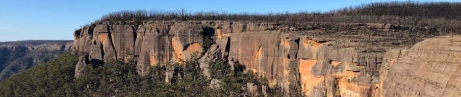
Looking out across the valley (upstream of the 40m waterfall), stunning cliffs.

Walking back along the Jones Creek Track we twice came to spots with these rocks on the rock plateau, very unusual, they are sandstone, the same as the slab they’re sitting on, if anyone can tell me what they are doing just sitting there let me know.
This was a 2 hour side trip, we were back at the packs by 10am and off on the long slog back to the cars.

When we got to the “shortcut”, we took the opportunity to do a 100m side trip to check out the old hut that used to be here in the old days. You can see evidence of a water tank and a metal chimney, all in a sorry state of repair (lol). Would be interesting to know who lived here, and what were they doing here, after all, the vegetation isn’t really suitable for cattle or sheep. I’ve been out on this track about eight times now and this is the first time I’ve taken the time to check it out.
So, back at the cars by approx. 1.45pm and all that remained was the tedious 4.5 hour drive home.
Thank you so much Emma, Heather, Steve, Murray and Jeff for humouring me and doing this walk, what with the scorched earth it wasn’t at all pretty, but the views were great and Jones Creek definitely needs to be revisited in the summer months (but maybe not by me, another IYDM trip?).
I was thinking Marilyn, that the area may have been a lot more grassy in the old days. Its very grassy now. When I was reading a book about Kanangra, prior to 1927/1928 massive fires (“the likes we have never seen before nor will again”)(not prophetic), the plateau was said to be grassy. The fire sparked up all the heath vegetation. I think the aboriginals may have spent a fair amount of time burning off both Kanangra and Ettrima areas, keeping the grass coming through and stopping the hakea etc. Wouldn’t have been much fun hunting through the hakea, let alone seeing your prey. If that’s the case then Ettrima’s past development is more easily understood. Whats your thoughts?
That certainly sounds logical, would explain why that hut was there. I had heard somewhere, not sure where, that the Ettrema Plateau was used by the aboriginals as a place that they sent people who didn’t follow the rules, that made sense to me, it would be a hard life there. I’d also heard that most places in the bush in the pre colonial times were not as scrubby as they are now because of the patchwork burn-offs that were done.