 BUNGLEBORI CREEK – OCTOBER 2015
Waratah Ridge > unnamed spur > Bunglebori Creek > Jeff’s Pass > Secret Campground #4 > unnamed ridges > Bunglebori Creek > Fire Trail #1 > Waratah Ridge
I had visited this campground twice before back in the dark ages and had remembered it as a fabulous walk with a great campsite and I wanted the A Team to visit it with me before I hung up my walking shoes.
So, we set aside the October three day Long Weekend for the trip. Jeff had visited the area with another club a year or so before, so we decided that we’d take the route in/out that he had used because I couldn’t for the life of me remember how I got there, or got out. If we came across the campsite I remembered, well, that was a bonus, if not, we would have had a great trip anyway.
G eoff S, Heather and Trish N joined us and we headed up on Friday night for an early start on Saturday morning.
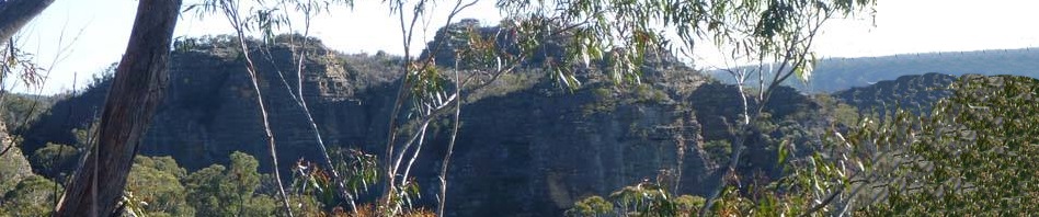
All went according to plan, walking up the Hole in the Wall track to a high point, at which time we set out cross country with Jeff navigating. It was fairly easy going, no mishaps and soon enough we were heading down a spur towards the creek. We then dropped down into a side creek which was easier going, there was a nice overhang and a small waterfall (left) where we dropped in.
We got to within cooee of the Bunglebori and were stopped by a cliff. So, we sat down  for morning tea and then scouted around for a route down which we soon found.
 We made our way down to the Creek and then headed downstream. It was pretty easy going, only one section where we had to get down on hands and knees to make our way under a big overhang, and not fall in the water, not easy with a full pack, but we all made it. The water just wasn’t warm enough for us to want to get wet feet!
Shortly after the overhang, we came to where Jeff thought the pass was. He clambered up the slope to scope it out. It was more eroded than he remembered so he asked Heather to take a look (she’s a better climber than me), they talked about it a bit and then decided that it was ok to give it a go, so the two of them climbed up and we passed packs up to them. By the time it was my turn to climb up, lots of rocks, dirt and other shit had come down and it wasn’t easy to get foot and hand holds, but I made it up and then there was another small climb and we were over the worst of it. We continued along, coming to an interesting rock formation (below) where you had to sidle along and before long were up on the top of the pagodas, the high point.
 We had lunch here and then scouted around for a way down from the top of the pagoda, we could see where we wanted to go, but no easy way down. Heather took the lead then and soon discovered “Heather’s Pass” (below), we used the tape to get down safely and were walking down between two pagodas and then through a big overhang. We continued along past the overhang and then came to this amazing flat grassy area, a 5-star campsite if I’d ever seen one (well, it actually lost a star, was only a 4-star site because we had to walk downstream for water!).
 I looked around and lo and behold it was the campsite that I had been to all those years ago (I recognised it from a big log that you had to walk under to go downstream). I had approached it years ago from a totally different angle, but it was definitely the same place. Also, back then we were in the middle of a drought and the nice grassy area that we had now wasn’t as green or as grassy.
We set up camp and then took our packs and goon bags to go and find some water. Where I had picked it up before was bone dry so we continued downstream until we came to spots with water, didn’t take long. Once we knew there was water, we continued downstream to the junction of our little side creek and the main creek. On Oliver C’s map, he’d marked this spot with a “C” which denotes campsite and I wanted to see if it was any good, ie better than the one we were at. We walked all the way to a waterfall, too big to go down and cliffs either side, so walked up and around it and to the cliff-line of the creek and peered down the cliff-face to the creek 30+m below. It did look pretty spectacular down there, not enough time to scope a route down, we’d have to ask Oliver how he got down there!
 Back at camp we built the fire, had happy hour and after dinner started our traditional game of May I?. Wasn’t long before we were all in bed!
Next morning we took a different route out and whilst I didn’t recognise anything, it was probably the route that I had walked in on all those years ago. Jeff did the navigation and we took the opportunity to look around a little on the way, there were some nice pagodas and some slots that we dropped packs and wandered down. It wasn’t long before we were at a junction when we had to turn north to get to the Bungleborie.  What a fantastic ridge and spur down to the creek, it just kept on going and going with great views and nice easy rock platforms to walk over. When we got to the end of it, we all looked around for the pass down. I walked over to a point and it was starting to look familiar so I continued down and yes, it was the pass that I’d used years ago, not the only pass though Trish N found her own way down.
 We were at the Creek for lunch and took the time to cool off. We then had to decide whether we’d go cross country to the fire trail, or go downstream for a k which would take us to the end of the fire trail. We opted for downstream, which in hindsight may not have been the best choice, was a bit scrubby. After an hour or so, we were at the end of the fire trail and then it was simply a slog up hill for what seemed like hours to Waratah Ridge and the cars.
This was a great adventure, the walk was easy, scenery spectacular and I got to go back to a place that I had remembered as being really special. I don’t know why more people don’t walk out in the False Western Arthurs (or Mini Arthurs as Jeff calls them), it’s a bushwalkers nirvana! Can’t wait to go back.
Pingback: Arthur’s Canyon – unfinished business | Adventures with M