 WOOLPACK ROCKS TRAVERSE – OCTOBER LWE 2015
Newnes Valley > Newnes Plateau > Collett Gap > Red Rock Creek > Woolpack Rocks > Hughes Defile > The Pondage > McLean’s Pass > Cape Horn
So, was it a dry walk because the coal mines have drained off all our water? Probably not, we’d done the recce walks, planned the trip, got together a great team, but failed to check the rainfall over the past 3 months.
I had been wanting to do the full Mt Dawson to McLean’s Pass walk (4 days) for many years but just never got around to it, the car shuffle was enough to turn me off. But then Jeff heard of a pass down off Cape Horn which meant that we would only have a car shuffle of a few ks, so, we put a shorter 3 day trip together for the October LWE.
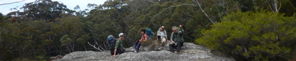
 Greg G, Geoff S, Heather R, Trish N, Jeff B and I were up for the trip!
We parked a car along Wolgan Valley Road, just down from Cape Horn and then drove back to the Donkey Mountain Car park and started off, up a spur to a couple of rock climbs through the cliff-line that would get us up on the plateau. All went well,  Heather did the lead climb on the climb that none of us like (way to go Heather), we pack hauled and we were soon up on top enjoying the sunshine, perfect weather and views. It was shaping up to be a great walk and we were on schedule.
We crossed the top of the plateau and easily found the pass down to a little cave where we had lunch which is our pass down to Collett Gap. By this time the temperature was heating up and it was so hot we were going through a lot of water but we had been told of the water source down at Woolpack Rocks so we weren’t overly concerned.
After lunch we headed off, traversing around to Collett Gap and then up the other side onto our route to access Red Rocks Creek. By now, it’s now really, really hot and due to my navigation and not wanting to end up in a creek, we accidentally went too high and had to re-adjust our route. Not to worry, we were soon at our side creek which leads into Red Rocks Creek, and we’re not doing too badly time-wise. Down in the side creek we sidled along and found the pass down into Red Rocks Creek. We were a little surprised to find that the creek was absolutely dry.
We headed upstream and it was very slow going, I got ahead of the others a little, and ended up sitting on a rock waiting for them. Jeff consulted the map and called me back saying that I was in the wrong creek (which then was christened Marilyn’s Creek), I said that I could see upstream and it looked like a good route, but I was over-ruled because our water source was up the main creek, not the little tributary that I was in. So, up we went to where the GPS showed our water source should be. Trish N and I went upstream to see how it was, the water source turned out to be a small soak, under a rock which in normal times should have had a pool of water in it, but this time … absolutely dry!
Now we had a problem, that was the only water source of which we were aware. We reassessed the situation, if we found water downstream, we were ok, if not we had to change our plans. By this time it was right on dusk, so Trish and I gathered all the goon bags plus a first aid kit and head torches and headed downstream to see if there were any pools further down in the creek. We continued down for 1.5k and did not find a single drop of water. By now it was dark and we put on our head torches and went back the way we’d come, through waist high ferns with logs waiting to trip us up, and tangles of trees and dead branches to get over/under. Not easy in the dark. We soon passed the dry water source and knew we were fairly close to our proposed campsite upstream. We had asked the others to call out and flash their head torches after 6pm, and eventually we heard them and could see where we should be headed, and climbed up the bank onto a small spur.
While we had gone, Jeff had looked upstream from our campsite on the other small creek (Marilyn’s Creek) and also found no sign of water.
Thankfully camp had been set up, they’d pitched our tents for us, and there was a nice welcoming fire. We sat around the campfire and listed our options, basically only one, have a dry camp tonight, conserve all our water and walk back out the next day the way we’d come and exit via Collett Gap (it was only a 7 hour walk back to the cars). Greg, bless his heart had carried in more water than the lot of us put together and had 3+l to spare, we pooled (no pun intended) all our water together and then divided it between all of us, giving us enough to do the walk out.
We ate what dinner we could (conserving water) and went to bed ready for an early start next morning to avoid the heat of the day.
 All packed up and ready to go by 6.30, we dropped down into Marilyn’s Creek (about 15m downstream of our campsite), with the intention of going up the other side and following the cliff-line out. And, what do you know, right below our campsite, there’s a big pool of water! So, if we’d gone up my creek that I’d said “let’s go up this one” (now forever referred to as Marilyn’s Creek) or if Jeff had dropped down a few metres further back from our campsite, we would have found the water and not suffered all that angst the night before!
 We loaded up with water, then had the cups of tea/coffee that we’d missed out on for breakfast and reassessed our situation … may as well continue with Plan A and head for Hughes Defile and The Pondage (our campsite for the night), and we were pretty sure there’d be water at The Pondage (I haven’t ever found it dry in the past).
The route across to Hughes Defile was very straight forward and we spotted the pass down easily and the pass up on the other side, then it was across to Jeff’s Pass (which Jeff had found years ago and was a nice walk through a ferny glen down through the cliff line) and across to Blue Ro cks pass. A compass bearing for The Pondage and we were at the campsite just in time for lunch at 1pm.
 I figured it would be a good idea to check out the mini Canyon that is the water source at The Pondage, so before having lunch we all headed down with our goon bags, it’s not far from the campsite. It was looking mighty dry in the canyon, in fact all the mosses had dried out and when we got to where the pool of water is, it too was bone dry!
So, we sat down and had lunch and again considered our options (a) stay at The Pondage for a dry camp or (b) go on to McLean’s Pass and overnight there with a dry camp, making our next day shorter. We were all feeling pretty fresh and it was only a couple of hours to McLean’s Pass so we opted to push on there, which would give us an early start the following day to get down to our vehicles in the valley – and water!
 So, we headed out. We’ve been on this route so many times, we know it like the back of our hands, we still enjoyed the little climb ups and downs and stopped to enjoy the views, but we all had in the back of our minds the following day and the shortage of water.
 Nevertheless, we arrived at McLean’s set up camp, lit the fire and proceeded to celebrate Heather’s birthday with Port, chocolate, Drambuie and a 6 person game of May 1? with 3 decks of cards. All things considered it was a great camp despite the lack of water!
 Next morning we again set of nice and early, it was a short 45 minute walk out to the fire trail and then down the fire trail towards Cape Horn. We arrived at Cape Horn by 8am, and we were all pretty confident of being back at the cars around 11. We then had to scout around for the Pass we’d been told about which goes down through the cliff line. Actually, there were a couple of options, one not so good as the other, and we were soon down.
Once down, we then had to traverse along the base of the cliff-line to the point, it didn’t look too far, but the adventure wasn’t over yet! We traversed along, and then had to drop down another level, there looked to be a footpad (probably wombat pad) and then we lost it. So, we were traversing across very nasty country, gullies to go up and down, no sign of a track except wombat pads, and it was hot as.
 Jeff was down below us and I figured he was set (little did I know that he was truly suffering from the heat), the rest of us headed back up towards the cliff-line to see if it was an easier route (which it was). After a while we all regrouped and then set off again. It was around about this time, as Heather was passing a small cave that she swears blind that she smelled water and there it was under the overhang a little drip pool. Most of us refilled with water and set off again, regrouping at the point of Cape Horn. It was by now lunch time so we sat down and recovered a little.
At 1pm we set off and negotiated our way down a spur that Jeff had chosen, and he unerringly led us straight to the cars. We were never so glad to see the cars, by the time we reached the vehicles, we were all down to around 100ml or so each of water, the day was that hot!
 So, we pretty much jumped in the cars and headed off to Donkey Mountain, picked up the other vehicle and then went to the Newnes Pub for ice creams and cold drinks (a big disappointment for Heather, a bloody pub with no beer)! Then we headed down to the river to have a wash and cool off, laying in the river until we had all recovered.
There was much talk about why there was an absence of water in the usual places, ranging from (1) coal mining under the plateau “taking” all the water (since disproved by Trish’s son who researched for us and there’s no coal mining in that part of the GoS National Park); (2) too many people visiting these wilderness places – we find that hard to believe; or (3) not enough rain. As it turns out, there was not enough rain in the 3 months previous, SO, now I’ll keep a record of when I go out that way and how much water I find and then look up the rainfall data for the area. Hoping not to be caught again.
Another walk crossed off the wish list, but now I think we’ll have to go back there to explore a little around the headwaters of Red Rocks Creek, we didn’t get very close to Woolpack Rocks or Woolpack Gap, and I wonder if there’s a better campsite upstream?
Pingback: How could there be two identical caves? | Adventures with M