 NSW SOUTH COAST – 25 – 30 November 2023
Pretty much every multi day trip I’ve been on in the past year we’ve had a massive rain event, and this trip was no exception … more about that later. Driving 600k south twice in the same year is unheard of for me, but the incentive of searching for sea caves made the daunting drive something I couldn’t pass up. So, I headed off, breaking the trip at my brother’s house in Milton …. still out of my comfort zone though, that’s a long way to drive!
Saturday 25 November – John & Kathy G (trip leaders), Rod, Marcia and I turned up at various times during the Saturday and checked into the caravan park, our base for the rest of the week. Onni would turn up on Sunday. We met up at the cabin that Marcia, Rod & I shared and reviewed all the research that John had done, much of it from the Illawarra Speleos, and the now defunct Bermagui Speleo club. John had all the maps and lots of GPS co-ordinates that we wanted to verify, and possibly survey. For the last 6 months, John has been on a mission to suss out all the sea caves up and down the NSW coast. After happy hour and a bit of planning, we called it a night.
Sunday 26 November – the plan for today was to drive to Green Cape (some of you might recall the trip in May where Trish, Cathy Peter & I spent a night at the Green Cape Lighthouse. So, I was in “known country”. We stopped again at the Disaster Bay lookout and then continued on to a the turnoff for City Rock – “unknown country”. Our goal was a cave in the City Rock area (YU229).

We were pleasantly surprised to find a well defined track out to the coastline from the “City Rock car park”. Looks like the track has been recently updated by NPWS. In areas it went through this lovely old tea-tree forest, really nice walking.

At the end of the track just before descending onto the rocks, we walked over an old Aboriginal midden – a spot where the traditional owners would have gathered and eaten the shellfish that they’d collected off the rocks.

Our first impression of the rocks – stunning! lots to explore.

And amazing colours – my guess is that this is a volcanic area.

Beautiful yellow lichen on a lot of the rocks.

Looking south – no way were we going to get down there, we didn’t think the cave would be to the south.

Rod checking just in case. Definitely a “no go”.

So, we headed across the rocks to the north of the rock-shelf.

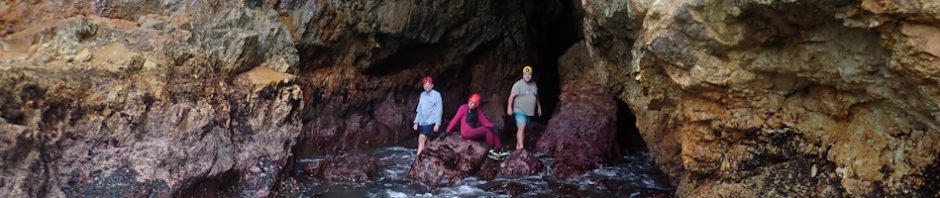
And John was the first one to get over to where the cave is (behind him but he’s checking out to see if there are more).

The cave, taken from the northern side of the rock shelf, you can just see Marcia looking at the cave, and (probably) Rod, at the entrance (photo: John G)

Getting to the cave was a bit challenging, the rock was quite slippery and neither Rod nor I had the right shoes on (a challenge for us for the rest of the week).

This gives you a bit of an idea of what we had to cross to get to the cave. I took this shot once I was across, going back was much easier!

Marcia’s a bit unsure about crossing, but once I was over, she had a major case of FOMO, so decided to risk the slippery rocks.

Very happy now she’s across!

Me coming from the back of the cave. Rod & I did a quick survey (not much cave, but it did go back quite a distance), I’m standing on a chock-stone and the waves are crashing into the cave beneath me going back in another 5m. It was pretty impressive, I took my slippery shoes off to get to the cave and walked in bare foot (much more friction in bare feet).

Marcia on the rock shelf, returning back to the access track we’d taken. Love this coastline! and the colour of the rocks!
Back along the track to the cars and a quick trip out to the lighthouse – much better weather this time compared to last May.

The lighthouse keeper’s house on the top lh corner, and the beautiful rocky headland (which would have been devastating for shipping).

The now defunct lighthouse – replaced by modern technology, but a beautiful example of early Australian lighthouses.
After having our fill of the Lighthouse, we headed back to another fire trail (more unknown country) and headed down to find YU91.

We scouted around for about an hour, being unable to find a way down to this small cove. Eventually, John went off by himself, after waiting for half an hour, Rod and I decided that this hadn’t been a good idea, and then, just when we were starting to worry, John said he’d found a way down, “a bit of a scramble, we’ll need a rope!”

This wasn’t looking good, the way down looked to be vertical! Then FOMO set in and I followed down the route that John took, it would be definitely easier coming back up!

John telling Marcia about the most efficient route down, and yes, it looks scary and it was! But going up was a piece of cake.

A little bit further down and it’s still almost vertical, with lots of loose scrub.

I can’t tell you how happy I was to get down to almost level land.

And, at the bottom of where we came down there was evidence of another Aboriginal midden, I’d like to know how they got down!

We set off around the base of the clifff looking for the cave, and just ahead of us was looking promising.

And even more promising from this angle (Photo: John G)

John’s photo from inside the cave.

And there we are we’d found YU91! there’s definitely a dark zone so it’s the cave we were looking for.

Marcia and Rod surveyed the cave and John took an accurate GPS reading.

It was pretty much low tide when we arrived, and we found these interesting sea creatures on the rocks (about the size of a $1 coin, and sort of like sea anemones when they withdraw into themselves, most unusual and I haven’t seen them before.

And then I had a go at underwater photography, with an unusually coloured sea urchin.

Interestingly at this cave we found a lot of flow stone, coloured red (iron in the rock?)

This was a particularly large piece, about 1m x 1m the flowstone is forming from water in the rock (cliff), dissolving calcium/calcite and when it comes out of fissures in the rock, it solidifies.
So, back up the vertical cliff and the cars and we’re off to the Pulpit Rock fire trail to look for YU224.

This is the view you get from the end of the tourist track which heads to Pulpit rock. I’d stood up here six months ago and figured there was a cave below but couldn’t se the way down.

We found a fishermen’s track which led us down to the base of the cliff-line.

My photos don’t give you a true reflection of the change in colour from one part of the cliff to the other. Again, I think this is due to some ancient volcanic activity. The cave isn’t much to write home about, but at least we were able to find it and get an accurate GPS, no point in surveying though. (Photo: John G).

This eroded rock was part of the cliff. You’d be forgiven for thinking it was cave formation, but no, just heavily eroded rock, if you touched it, it crumbled in your fingers.

Marcia looking out to sea. When I stood at the top of these rocks, I thought “that would be a cool jump”, but nah, certain death. The rock is very interesting though, like a lava stream into the ocean.

Great contrast of the two different types of rock.

When exploring another rock outcrop, we found these strange circular indentations. I imagined that the volcano was throwing up these cannon-type balls, and they were being embedded into the lava flow. Probably not what they were but sounds good doesn’t it.

Another one, they were slightly larger than a tennis ball.

And a couple more higher up.

On the way back to our base, we ran across these two women from Victoria with a flat tyre, and they discovered that their spare was also flat. Luckily John has a compressor in his car, so he pumped the spare, only to find out that the spare also had a hole in it and wouldn’t hold the air. Fortunately, roadside assistance turned up 5 minutes later. They were going to have another hour’s wait for a tow-track to rescue them.
When we got back, we found that Onni had arrived, so, another happy hour and chat about the plans for the following day.
Monday 27 November – We knew that rain was heading our way, but we weren’t to be put off by a little rain, and we expected to get wet anyway, so we headed to the Merrica River, we were looking for Merrica Cave (YU76) and the Merika Bat Cave (YU75).

We drove to a parking spot before the weir, we didn’t want to drive across, just in case the river level was such that we couldn’t get back again. Onni, Marcia and I all took rain umbrellas as it was already raining!

The weir, doesn’t look bad now, and even when we came back across at the end of the day, the water was just ankle deep, but you never can tell.

We followed a NPWS track which would lead us to Merrica beach. This section was ok, but there were a lot of fallen trees to climb over and under.

We were surprised when we came to the lagoon (the beach was daming up the river, so there was a large lagoon to cross, with no obvious way to walk around it). So, some of us stripped down a bit to stop clothes getting wet, the rest of us just went in as we were already wet. Onne & John said it was only waist deep, which for me was neck deep – someone took my pack across as it wasn’t dry-bagged.

Once across the lagoon (which you can see on the far right of the image), we went to the south to find Merrica Cave (YU76). Lots of rocks to cross, and I was very cautious because of the rain, couldn’t tell what was slippery and what wasn’t.

Continuing south along the coast looking for the cave.

We got to this ledge, a bit of a climb to get up to it, then we went along and discovered that it cliffed-out, we could go no further so had to retrace our steps back a hundred metres or so and then go higher to get around this section of rock.

We found the best spot to go up into the trees where we thought there would be a good route.

Passed another midden – boy those first nations people sure were fond of their shell fish.

By now we were high enough, but the way ahead was still dodgy. I waited where I was and let the others go along that dodgy ledge. Eventually they agreed with my estimation, it was dodgy, so came back to where I was sitting.

We headed back up into the tea tree forest again. John and Onni decided that they would go ahead and suss out to find a way to the cave. Rod, Marcia and I waited in the tea tree forest, where we were somewhat sheltered from the rain.

After half an hour waiting, Marcia was starting to feel the cold so I suggested a fire. Rod was supportive, so I managed to start a small warming fire (mostly with wet kindling and half a box of matches and some toilet paper. By the time they got back we had a nice warm fire going, easy to put out with the wet vegetation and rain! They had found the cave but it was too difficult to get to!

So, we retraced our steps back to the beach. I had a few oysters along the way!

Looking from the south headland of the beach, it was easy to see across to the northern headland and where we expected the bat cave to be.

The rest of the team walking over to the northern headland (Photo, John G).

At the headland we found two “canyons” and the cave. This is the first canyon.

The second canyon. This is worthy of a number and to be surveyed, it hasn’t as yet been tagged/numbered.

And then we were able to walk to the actual cave, it was full low tide by this time, although we still had to walk through some small waves.

And here we are Merika Bat Cave (YU75).

At full low tide it was pretty impressive to get to the entrance.

Looking back to Rod as he’s coming in.

If you go all the way to the end of the cave, there’s a hard right hand bend which you can crawl along. Where the light is (Rod’s head torch), there is a NPWS notice that notifies people not to go any further as there are bats in this cave and you would be disturbing them. Rod’s the only one that went up to the sign, and then notified us and the rest of us didn’t go any further.

Photo of Marcia looking out to the entrance, it’s quite a long cave. Exiting, I was actually bowled over by a wave, was pretty scary, I could easily have been washed up to the barnacle covered rocks and suffered some skin damage.

After we’d had our fill of the bat cave it was back across the lagoon, this time we took a slightly different route and it wasn’t so deep.
Tuesday 28 November – Weather very overcast and rain (the start of the rain event that’s forecast for Wednesday). Not to be deterred by a bit of rain, we drive out to Worang Point to try to locate YU176.

On arriving at the parking lot at the end of a very rough fire trail, we’re amazed by the smick walking track that’s been installed by NPWS.

And the impressive look-out with steps down to the rock platform. There’s a second lookout further around. Given the amount of track maintenance that’s being undertaken by NPWS, it’s my suspicion that a load of money has been thrown to this area as a result of the bushfires that went through a few years ago.

View from the second lookout. I love the way that the rock fingers extend out into the sea.

Once you go down the steps at the side of the lookout, you encounter this amazing rock platform. It was quite steep and given I hadn’t brought my Bestard shoes (grippy sole), I cautiously negotiated my way down this slope.

John looking around to the left for the cave. We decided that we had to backtrack to the lookout and head around through the tea tree forest to find a way down.

We found a route, near what appeared to be a bush campsite, then came along all this toilet paper. There was a lot of tutting about people not “doing the right thing”, but there was so much of it, I suspect it was a bandicoot that had “stolen” the roll of toilet paper and when the bandicoot discovered it wasn’t tasty abandoned it and left it to the elements and wind.

The cave in the right-hand corner, you can see that 45° rock on the left that we’d walked down. We’ve found the cave (YU176), but it will need an abseil on a future trip (by now we’re so enchanted by the area that we’re already planning the next trip).

Poking around for anything else on the platform.

Making our way back through the tea-tree forest.
Back to base to warm up, dry off and have lunch and then we headed for Lennards Island which is close to Eden. Yet another good NPWS walking track with a railing and good steps down to the beach. The beach between the mainland and the island (joins the two), was covered in a lot of sea-weed and caught amongst the weed were an amazing number of sea urchin shells (intact), ranging in size and variety. I collected a bucket load to bring back for my granddaughters Liana and Audrey.

The first “cave”, not really one, but it’s a fissure and will eventually become a cave!

The second fissure. Then we walked around to the northern side of the headland, rock hopping for 50m or so from the steps down to the beach.

And here it is the cave (YU236) that was documented as being here. Again, we did a new GPS co-ordinate, but no need to survey.

The floor of the cave was covered in an impressive amount of abalone shells. On thinking about it, I think an abalone fishing boat mored off shore, then the divers brought up the abalone and the guy on deck took out the abalone meat and threw the empty shells overboard. With years of heavy seas, the empty shells were deposited between the rocks and in the cave.

This photo shows you the depth of the cave, it’s dark at the back but is only 2 – 3m deep.

Marcia at the entrance of the cave, always good to get a shot looking out the entrance.

John and Onni headed around the headland looking for another small cave (apparently it was so narrow that Onni only just fitted into it), Marcia and I headed back up to the car.

The rain was relentless – Marcia looking down to where John and Onni would have explored.
We were happy to see John and Onni return to the car, we were cold and wet. Back to camp to dry off again and set our alarms for 4pm to coincide with full low tide at 4.30pm when we intended to visit Yallumgo Cove (and Cave YU72). Full low tide is the only time we’d be able to gain entry to this cave which entails a small down climb and a deep wade.

From the parking lot and track to the cave – looking over to Eden.

John on the track down to the small headland.

Bit of a downclimb to the entrance to the cave. Looked really dodgy going down but was fine going up.

Onni continuing the downclimb to the entrance.

And making his way across to a small rocky shelf. It was at this time that I decided I wouldn’t risk this. With the swell of the incoming waves, if I had tripped or slipped, as I didn’t have a wetsuit on, my legs would be shredded by the barnacles on the side of the rock. So, I watched the others exploring :(.

Now they’re all at the cave for a photoshoot.

The cave is really amazing with pink coraline algae up to the high tide mark (the pink stuff you can see on the rocks). It looked much better than the photo shows it. Apparently, there were also a lot of sea creatures in the cave including sea urchins and star fish.
Back to base camp for an evening of board games!
Wednesday 29 November – As John so eloquently put it, on Wednesday “all hell broke loose” so we spent the day in the cabin playing board games. BOM observations claim that we had 100 km/h gusts at Green Cape (the lighthouse) and the rainfall for November was around 180mm – I’m pretty sure we had all that in one day!

Management came around and asked those of us staying to move our vehicles away from the edge of the creek. Most people staying (in vans and tents), left the area, John’s annex on his caravan spat the dummy, Onni’s tent leaked a little and the creek rose up to the edge and looked like spilling over into the road, but then the tide turned and it went down pretty quickly. We’re all board game fanatics and Rod had brought a collection, so we were snug and dry.
Thursday 30 November – Taking two cars, and with the hope that the rain would hold off, we drove out to take a look at Boyds Tower. The rain didn’t hold and when we got there, Rod and I decided to give Boyds Tower a miss. The others went out for a photo shoot, apparently Boyds Tower was visited on Kathy and John’s honeymoon and today was their wedding anniversary, so it warranted a photo, even if it was raining.
After the tower, Marcia, John and Onni, went off to explore YU82, 83, 84 & 85 in East Boyd Bay. and Kathy, Rod and I decided to visit the Davidson Whaling Station.

We followed two sedans down the fire, the two cars stopped occasionally to move tree branches off the road, but when it came to these two, they gave up. So, we all backed up to a spot where you could turn around (so that they could get past us), and they retraced their steps, we parked the car, as it was only a 500m walk to the old Whaling Station.

The two previous saplings looked like they could be moved, but just around the corner we came across these ones, they def couldn’t be moved.

The cottage which was home to George & Sarah Davidson and their eight children. Three generations of the Davidson family, between the late 1920s until the 1980s, operated a shore-based whaling station, and was the last of its type to close.
Apparently, it’s the only site in Australia where marine mammals (a pod of Orcas) assisted by Aboriginal people helped in the harvesting of the whales by driving the whales onto the beach. Not sure whether this was documented history or urban (or South Coast) myth. The whale oil was then extracted from the whales at a try-works site.

View of the house from the track down to the oil extraction site. There were a lot of fruit trees when the Davidsons where here, the historical society has planted some new ones.

There wasn’t much infrastructure left at the oil extraction site, a few of what looked like big metal stoves, and this big tub. Apparently, there have been many floods on this river and a lot of the infrastructure was lost.
Started raining again on the walk back to the car, the three of us were happy to be going back to base for a hot shower. We’d made a reservation at the Seahorse Inn for dinner to celebrate their anniversary with John & Kathy. Fabulous food, I did have food envy.
Friday 1 December – Onni, John and I left around 7am to drive to Seahorse Inn to walk along the beach to see if there was anything there. Marcia departed whilst we were gone for the drive back to Sydney. There wasn’t a whole lot for us to see on the headlands but we did do a good fitness walk and made our way up to the old Church on the hill, we all decided that the Boydtown historic walk was definitely worth while doing the next time we were down this way.
Back at the base, I packed up and was ready to leave by 10am for the drive up to my brother’s at Milton. I was a bit worried about rain but once I’d left the Eden area, the weather was really good, no worries at all driving on wet roads.
It was a great trip, thanks John for suggesting it and putting it on the MSS calendar. Your research for the trip was amazing – once we figured out the “problem” with the maps and GPS grid references (a Department of Lands/Central Mapping Authority interesting way of dealing with the curvature of the earth and what happens with a thin slither of land is on a map with lots of ocean to the east). I’m really looking forward to next year’s exploratory trip!
So, this was a recce trip to see the lay of the land. Here are my takeaways from the trip …
- John found a few new caves, so, even though other clubs have documented a lot of the caves, there are still some to be found and it was worthwhile updating the GPS locations and in some instances surveying them.
- Ingenia Holidays Eden Beachfront was definitely the place to stay to check out the caves – cabins were great, not a huge park and great amenities, we’ll go back there.
- The change of tide (low to high, high to low) makes a great difference, with most of the caves they were more accessible at low tide, plus, the swell played a big role.
- Based on the above, two weeks would be better than one, then if the swell was too big, you could wait a couple of days for it to calm down.
- The photography isn’t as good, but it really doesn’t matter if the weather is inclement, so long as you have a dry bed/kitchen to come back to (LOL).
- Next time take a wetsuit so barnacles aren’t a hazard.
Great report in my neck of the woods. Interested to hear about the bat cave at Merrica River as I have camped there a half dozen times paddling down to Mallacoota and never found the deep cave.
Some very good caves also in the Nadgee Wilderness Area.
Why, thank you Sandy, so nice to hear from you. We are looking to get to the Nadgee Wilderness area, not sure when, so many things to do, so little time!