 KIMBERLEY REGION – 4 – 10 July 2022 – So, last week we found a number of large caves that needed surveying; only the surveyors are in camp now, everyone else has gone back to Kununurra. The weather is still being kind to us and we’re all fired up to see what secrets will be revealed in the caves we’ve found. Morning temperatures are still around 8ºC but I’m a bit warmer now as the Lovely K has given me a hoodie to wear!
Monday 4 July – two vehicles drove over to the Banana Boab parking spot, one group were going to survey Banana Boab and the MAD surveyors (Marilyn, Alison & David) were crossing over the Banana Boab outcrop and walking 2k walk to KNI162 a cave that looked really promising last week.

The country we were walking through was quite nice, grass not too long. I was walking behind David, then Alison was behind me. There was a blood curdling cry, apparently I’d unknowingly brushed a snake with my boot and Alison saw it. She said it was a brown snake (eeek) and was super cautious after that, as was I! We walked on and then David reaslised he’d overshot the spot by 350m (“but it will be easier to find from this direction”) so we turned around and backtracked. The walk in ended up being closer to 3k than the promised 2! The good news is that someone’s phone “pinged” we had reception. We all pulled out our phones – I messaged David to ask him to check on the Pool as there’d been another deluge on the Central Coast!

David drawing the map, Alison and I either chose “stations” to measure to, or used the DistoX to measure. We were pretty efficient.

We surveyed 190m of passage in just under 4 hours, the cave wasn’t as big as David thought but had lots of side passages.
We exited the cave and made our way back to the Banana Boab outcrop in under 1/2 an hour, then sat in the shade waiting for the others. They hadn’t quite finished the survey so we’d be going back later on in the week.
John said he had a surprise for me – I was worried that it was a snake, but it turned out to be two Cane Toads – John had found them in Banana Boab cave. I’d shown a lot of interest in the Toads and John is a member of Kimberley “Toad Busters” he caught the toads with the intention of euthanising them.
For my overseas friends, a bit of background on the Cane Toads … Someone back in 1935 had the bright idea of introducing Cane Toads to Australia to control pest beetles in the Queensland sugar cane crops. A government entomologist went to Hawaii where the toads had been introduced from Puerto Rico. He brought a breeding pair home and by August, at the Bureau, the toads had successfully reproduced 2400 little toads in captivity and they were released. Amazingly no studies on potential impact on the environment were carried out and the Bureau of Sugar Experiment Stations hadn’t even determined whether the toad would actually eat the cane beetles.
A prominent entomologist was (rightly) concerned that the toads would become a significant pest, and he fought to get further releases of the toad banned, but in 1936 PM Lyons succumbed to pressure from the Qld Government (and the media) to rescind the ban and the rest is history. they’ve travelled as far as the Kimberley Region now and have even been found in Sydney. You’ll find the full story here.
For more information go to Kimberley Toad Busters but basically their home page says it all “The work of the Community group Kimberley Toad Busters has clearly shown that by community involvement in controlling cane toad population numbers in a given area you minimise the chance of native predators attacking and consuming a toad, which in turn reduces the number of native animals dying as a the direct impact of the cane toad. Keeping toad numbers (adult and all breeding cycles) under control also helps the smaller insect eating native predators such as frogs, smaller skinks and lizards by reducing food competition. With cane toads capable of eating around 200 insects a night, uncontrolled numbers of cane toads increases food competition very quickly so the loss of smaller native species (full extent yet unknown) is probably quite significant (KTB research is supporting this conclusion). Kimberley Toad Busters field based research activities are primarily focussed on understanding the impacts of cane toads on wildlife and on developing ways to manage these impacts.”

Needless to say I’m not a fan of the Toad. So, what to do with the little bastards?

Put Detol or any other household antiseptic in the bag and they will very quickly die. Apparently hitting them on the head can cause the toxin to squirt everywhere, possibly in your eyes causing temporary blindness, excruciating pain and a trip to the hospital – for us humans, not the toads! Ann took one for the team and gave them an indecent burial a couple of days later.
I was on high alert in the caves from this moment on, but really didn’t want to find one, and I didn’t have a plastic bag. John must have had x-ray vision finding these two!
Tuesday/Wednesday 5 & 6 July – The full contingent, in two cars, went over to what we’d call the Bore Parking spot and headed out to survey two caves that are side by side in a large outcrop of limestone, David, Bob P and I would be surveying KNI159, David thought it would take 1.5 days – it took 2 and we still weren’t finished with it!

So, where to start? We dropped down to a T intersection from the entry grike, 2 ways to go, we chose right. We surveyed the passage and now we’re in another grike,

We surveyed to the end of the grike and started into the constricted area.

Bob would set the survey stations (going ahead and finding a spot which would be good to survey from, and I used the DistoX to survey from the previous station to the next station, there’s an art in picking the right spots to choose as stations. Then after using the DistoX, David records the measurements and then draws in the map.

It’s a slow process, here David’s back at the previous station and checking how to depict the walls of the cave.

Interesting rock formation between the limestone, it’s almost like flakes of what would have been silt a million years ago.

Surveying to the end of a passage, I had crawled over or under this to do the measurements, then it was up to David to depict it in his drawings.

This formation was very fragile, fortunately we were able to approach it from either end and didn’t have to walk over it.

Bob is so strong!

This is what a drawn survey looks like, it’s rough, all the data recorded will be entered into a computer program and then it will be redrawn using the data, and hopefully will look like this. The best part of surveying is when you close a loop and you’re not out by metres and metres (lol). I can’t remember which cave this was, but you get the idea.
On Wednesday I woke up to 8ºC again, I’d brought my summer sleeping bag and it just wasn’t cutting it, even with the Lovely K’s hoodie! We’re off again at 7.30 and the 2k walk to the cave, “we’ll be finished by lunch time!” says David – nope, not even close. Back to KNI159 and we found more convoluted passages than we could count, lots of decorations and a few nasty crawls. The good news is that we had voice contact with the surveyors in the cave just along from us which means there’s a connection, it’s always exciting when that happens. We found a climb down (too difficult for me or David), Bob went down and met up with the others who said they’d just been through a nasty crawl, thank goodness I didn’t have to do that.

We were not the first people to go into the entry grike, it would have been a very good spot many, many years ago, and these two items were left behind. We think the small box was a vulcanising kit for a car or bike.
Back at camp, during happy hour, Ann offered me their spare blanket (they’d pulled the doonah out of storage), I jumped at it and had the first uninterrupted sleep that night, toasty warm.
Thursday 7 July – some of John’s friends from Kununurra came out to do some caving with us. The plan was to go further north by car from where we were camped to check out an old trip report that Bob K had found.
Apparently, the year before the cavers had flown over this area and picked out potential cave sites and written that they’d found one and tagged it. So, we set off to find it. We were looking for a valley that had a lot of cycads.
We found the spot where they wrote that they’d camped (after a bit of wandering around) and started walking. The first valley that we came to we discarded (we felt it was too soon, we’d only been walking a short time), so we continued on; and kept walking; and kept walking. Eventually everyone but Bob and David W were lazing around in the shade, we picked the trip report to death, it said that they’d finished looking at the cave by noon, so they wouldn’t have walked as far as us.
Then we heard that David W was finding some interesting things up at the base of the cliff-line, so, David, Bob P, Alison and I headed up to join David W. He’d hit the jackpot and KNI163 aka as Marvelous cave was found. Some very nice formations photographed by David W after 2 small crawls through dust.


When David W had had enough of the cave, he came out and sat with me (I wasn’t ready to go in yet). We got to talking and he mentioned that when he was traversing at the cliff-base, he found a number of aboriginal art sites and that some of the places he saw were definitely “secret men’s business”. He told me about the pinnacles that were along the cliff (a couple of very large stone pinnacles separate from the cliff face) ad explained their significance. I asked him later that day if he could repeat what he’d told me about the pinnacles so that I could write about it and he said he couldn’t because he wasn’t a traditional owner and so it wasn’t his story to tell.

Photo of a pinnacle from a distance. Out of respect I didn’t go and see the art or go near the pinnacles. But here’s the thing, if no-one talks about this, then those of us who blunder up to the sites don’t know that we’re encroaching on a sacred site. I guess we should just assume that all sites are sacred, not talk about them, not photograph them. Would probably be the best approach as far as the traditional owners are concerned, but doesn’t really allow for the opportunity to share what a rich cultural existence they led.

Ctenotus lizard found at the opening of Marvelous Cave.

Eventually we all walked back towards the cars and David W decided to go up into the first valley that we saw and discarded, and low and behold, the bloody cycads. The group are going to have to come back next year and explore this valley for the lost caves, we’d run out of time.

Boab tree, I’m convinced that these markings are aboriginal. Only the really big trees have them on them, the smaller trees (with branches at the same height as the big trees) don’t have them, the markings are all at the same height and are usually at the opening of a valley, sure to be “markers”.
Friday – 8 July – Brian had to finish off part of Banana Boab that they’d not had time for earlier in the week, and David W-C said that he thought they’d missed a section that he’d seen on the first trip in “We went into a big flat area and then found this hole” which Bob P cannot remember”. So we went back in to finish off the survey and try to find David’s “big Hole”.

The walk to the cave.

Inside the cave now and we’re on a mission, no stopping to look at the amazing formations.

This is one of my favourite parts of caves, apparently they’re phreatic formation – like the dragons teeth in Eagles Nest at Yarrangobilly.

We did find David’s “hole” and it turns out that Brian and Bob had surveyed it. The hole was at a dead end and the most disturbing thing of the whole trip was that we found that on some flowstone, in two places, someone had etched an arrow in the flowstone showing the way out, and the worst part is that it wasn’t even needed as the way out way evident. It’s just “not on” doing this in a cave, so whoever was in the cave was not a real caver and if they did this, they had no business whatsoever in being there, very disappointing to see.

We got to a down-climb – I said “no way”, and Bob K and David W-C agreed – no way were we going down that. Bob P took his pack off and went down.

Then Brian E (after having rigged a tape to either go down more safely or get up, not sure witch), went down, even he made it look hard (lol). After they were down safely we picked up our stuff and went to the daylight hole that they had come down so that we could survey the remaining cave.
Lots of surveying to do, two massive big chambers and lots of side passages, very nice formations.


This formation was particularly lovely, looks like a Christmas tree (photo: David W-C)

And a whole shelf of Christmas trees (photo: David W-C)

This is something none of us had seen before, a shawl with nodes on it, the nodes were as big as 20cm. (photo: David W-C)
Saturday – 9 July, our last day of caving. We walked from camp for quite a while, taking photos of Boab trees (and their unusual markings – still think the markings are scars of some kind), and then we went to KNI79 to finish off some surveying to complete that particular project. Bob K, Alison and I finished off a passage close to the entrance and then moved to another grike, and then over to a cave that Alison found – she was excited, she thought she’d found another cave. Unfortunately it wasn’t a new find, just part of a cave that had already been surveyed, KNI80 Cathedral Cave.

Dropping down into the “new” cave that Alison thought she’d found.

When we got to the bottom of the rocks (seen in the middle of the photo here, looking back at the rocks), Bob knew immediately where we were, in Cathedral Cave. It’s absolutely awesome, he took us for a short tour of just one small passage of it.

Looking up at stunning formations.

Cave pearls.

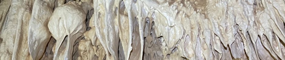
So many stalactites.

This gives you an idea of the size of this cave, you can just see Bob in the bottom in the orange shirt, and Alison coming out of the side passage. Yes, I know there are big caves elsewhere in Australia, but this has to be one of my favourites, would like to come back one day and go through the whole system (it’s huge).

More lovely formation.

And now, after having done a bit more surveying, we’re back where we started, waiting for the others to return, lovely lighting at this time of day.

I did a little walking around and found some cool stuff – here’s a Green Ant nest, these little buggers can give you a nasty bite, if I find them by themselves I usually pick them up and eat them (they taste of lemon). Best not to brush up on a nest like this, they’ll be all over you like a fat kid on a big mac.

For the past two weeks I’ve been doing a lot of walking over the limestone, thought I’d let you know how dangerous it is for me, everywhere up on top of the caves, there’s this nasty sharp rock, one fall on that and I would have been bleeding like a stuck pig!

A butterfly I found.

Whilst waiting for the others to return, Alison did some scouting around and found these rocks which are particularly significant, they are not from the area we’ve been in and look as though they’ve been “worked”.

And finally, some images which I think go towards my theory that these “marks” on the Boab trees are possibly aboriginal markings, indicating something “important” nearby. These Boab trees are very, very old, and the markings are all at the same level on the tree, about 1 – 2m up from the root system. They aren’t marks from branches that fall off, of that I’m sure, and they are either horizontal slashes across the tree (a metre long), or circular markings … haven’t been able to find anything on line to prove my theory, but am still looking (lol).


 And, so ended my 2 weeks caving and cave surveying in the Kimberley Region.
I hope that these expeditions continue for years to come, and that we can encourage younger cavers to learn to survey so that they too can go on these trips and experience wild caving to this extent. So, my younger caving friends, next time there’s a course to learn to survey sign up, or, come on some of the trips that MSS puts on the calendar – it’s really easy to start at the base level.
These 2 weeks were an amazing experience, a big thanks to all the group for your support and an even bigger thanks to Bob K and ISS for running the trip. I was extremely fortunate, I had marvelous weather – it’s not always like that, and I got a lot of support getting to and from the area with David W-C, words cannot express how thankful I am, thank you David!
Thumbnail: what a LiDAR image looks like.