 KIMBERLEY REGION – 27 June to 2 July – I was honoured to be accepted on an ISS cave surveying expedition to the Kimberley Region, specifically to the Ningbing Ranges. The first ISS surveying trip was in 2009 and they’ve been going back pretty much every year since. Other cavers had been to the area quite a few years earlier and had reported that there was “not much there”. How wrong they were!
 The Kimberley region is the northernmost of the nine regions of Western Australia. It is bordered on the west by the Indian Ocean, on the north by the Timor Sea, on the south by the Great Sandy and Tanami deserts in the region of the Pilbara, and on the east by the Northern Territory. I have to admit, I really didn’t know where I was actually going, but had always wanted to visit the area.
Bob K, who was our Fearless Leader, had applied for permission from the cattle station so that we could check out caves on that property and had also applied for a National Parks permit for us to both cave and camp in a Conservation Reserve. The land on which we were camping was returned to the traditional owners a few years ago and is managed by both National Parks and the traditional owners. And so I’d like to acknowledge the traditional custodians of the land and pay my respects to Elders past and present.
Our expedition group was Bob K, Ann & Bob P, Alison, John & K C, Brian E, David W-C and me. Others would come and go during the course of our stay, but this was the core group. Good group dynamics and excellent caving, the experienced exceeded all my expectations.
Monday – 27 June – We set off from Kununurra early on Monday morning and headed for the pastoral station where we “checked in”, then drove to our campsite. It took quite a while for us to drive in on dirt roads, many gates to go through and cattle to dodge. Once we got to the campsite, we set up camp, everyone with solar panels set them up in optimum positions to charge batteries. A couple of the guys then walked further into the busy (about 200m) to dig a latrine for our stay. After all the housework was done, we settled in for happy hour (a daily event).

The track into the campsite

David W-C setting up his camper, my tent is over the back in the long grass. David had brought along a hedge trimmer to cut down the grass where we all camped.

The creek we were camped on, lovely sandy bank at the swimming hole, the water was flowing, evidence of the rain they’d had back in May.

Looking at the pool from the sandy bank, our campsite is just at the top of the rise, so close.
Tuesday 28 June – The weather was very mild and so we spent Tuesday doing a bit of surface trogging, looking for holes in the hills which might indicate caves. We were using a LiDAR map which shows “holes”, much better than just roving around, at least we had “potential” caves. But before doing the trogging, we headed over to Banana Boab cave that we’d been told about. Nice cave, easy to get in and lots of decorations.

The unassuming less-than-impressive hill of limestone that held the cave.

The cave entrance, even less impressive than the hill, but wow, once inside it sure kept on giving, but more about that later in the trip, this was just a quick recce.

Nice decoration.

Even nicer!

Bob checking out a hole.

A daylight hole. Bob & Brian would return to this and another one (as yet not seen), and abseil into the second one (the longer abseil of the two), and David, Bob & I would go back to it later in the trip to survey this part. The main part of the cave would be surveyed by others over the weekend.

Bob checking out one of the LiDAR holes (both Bob and Brian were keen to go down the holes, the rest of us sat back and watched.)

One the way back to our vehicles, nice easy walking, Kapok tree in flower in the foreground – the fibers in the seed pod were what was used for pillows and mattresses in the “old days”. Back camp and happy hour!
Wednesday – 29 June – we set off at what would become our usual start time 7.30am. Ordinarily, on an expedition such as this, they would have started around 7am to miss the heat of the day, but we were having unusually mild weather, and lots of cloud cover, so it wasn’t as hot as it usually is. We were checking out the area using the LiDAR maps again, checking out holes. We found 2 really small caves and a larger cave.

Cave coral in what I called Skinny Woman cave, not a cave at all, just a slot in the rock that only Bob and I could fit into, tore my shirt to pieces getting past this cave coral.

This slot showed up on the map and it’s was what Skinny Woman was in the side of.

A daylight hole in the next small cave.

Walking out of the cave, not much bigger than this.

Although it did go a bit further, which I checked out and then Bob P decided he should check it out too.

Up on top of the karst now and Brian dropping into a hole, boy I wish I was younger and could follow him down, but I’d never get out!

Up the top, Brian getting out of the slot.

The cliff walls in one area, would love to know how the coral reef had formed these different strata, was it something that was more soluble that caused these different strata?

Finally the entrance into a bigger cave, we’d be back next week to survey this!
Thursday 30th June – found 2 small and 2 big caves
Friday 1 July – Have I mentioned that the weather was unseasonably mild, cloudy most days and temps of mid 20s during the day and quite cold at night. Good for walking! And then on Friday morning it started raining of all things – in the DRY season. None of us wanted to walk through wet thigh-high grass, so at the first suggestion of a “rest day”, we all jumped at the chance for a day lazing around and reading! Rain stopped late afternoon, held off during happy hour and then started again!
Saturday 2 July – With some Kununurra resident cavers arriving for the weekend, our group split up – some going to Banana Boab to do some SRT into the holes we found and the rest of us off to do some horizontal caving. I decided, after seeing the photos that David was taking with his phone, that as there was no water to cause any problems, I’d take my phone into the caves for photos, you’ll notice the better quality from here on!

I was in the group which would be doing horizontal caves, we walked from camp for about 2k through open grassy savannah, John C leading the way to caves that he’d visited before.

You see a lot of Boab trees in this Region – these are genetically related to the Boabab trees in Africa, they are very slow growing, and it’s suspected that when the aboriginals travelled to Australia from Africa that they brought the seeds along with them. Many of the very old ones have scars on them, this one with a line and three “holes”. I have no evidence to confirm this, but I believe that the trees with these scars were signposts for the traditional owners, they are often at the start of a valley.

The first cave that we went to KNI75 had a big limestone slab above it.

Fig roots from a tree above, dropping down into the cave, very large opening, you can just see John in the distance.

Someone said this is a Splendid Tree Frog, it was well into the cave.

Another frog, species unknown, but definitely not a Cane Toad.

Stunning formation.

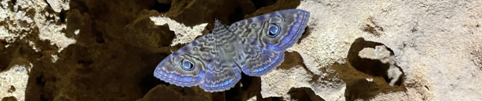
A Granny’s Cloak Moth (Speiredonia spectans), this was the first one I saw, but most days we encountered them, sometimes a dozen or so in a cave near the entrance – beautiful.

In the middle of the photo is a “hanging ledge” for want of a better description. In the past, the earth, sand, rock would have been up to this ledge and would have calcite form on it, then the earth, sand beneath it would have eroded away, leaving this formation, it would probably be strong enough to stand on.

Looking into another chamber of good decorations.

David at a small climb up.

The cave we were in had two main passage or streamways – we’re now in the second one and there’s a bit of a climb down, David showing Les, who is a relative novice caver, the best way down.

Now we’re in KNI83 which was quite a short cave but had a load of rimstone pools (or gours) we had to tread very carefully to avoid damaging these formations which are on the ground.

Our next cave was KNI77a aka GNT, the party was now down to John, David, Les and me – probably the most memorable thing in this cave was the small banded tree snake that was deep in the cave. I’d been worried about snakes in the caves ever since David told me to expect them. I was imagining big-arse pythons but these snakes are quite small and although venomous have small mouths.

Crawling through a passageway (pre snake sighting), lovely formations.

More formations this time with rimstone pools. These are formed when the water flows down and pools at the base of the formations.

More nice formations.

The cave just kept giving!

Possibly this is the biggest Shawl that they know of in the region, absolutely beautiful when back-lit (thanks Les).

Deep in the cave there appeared this root, from either a fig tree or boab, the root was growing up from the ground (there would be water in this cave during the wet season and it would take a long time to drain away. Interesting way the root has formed though, it was about 5′ high from the ground.

Looking up at a section of stalactites, you’d be seriously injured if one fell on you (lol).
Sunday 3 July – There are two known caves close to our campsite, Nice Cave (the name is definitely lacking in imagination), and Gorgeous Cave (you really had to see it with a name like that!). We went looking for Nice Cave in the morning and couldn’t find it (something about a dodgy grid reference). But we did find another cave which we tagged and surveyed. If we were into naming caves I would have named this cave Nasty Crawl Cave, we all made it through the crawl but it wasn’t pretty, smaller cave than we expected when we started surveying but unless you do a thorough recce, you don’t know. We went back to the camp for lunch (a luxury), then headed out for Gorgeous Cave.

Before setting off, Brian and David checking out GPS locations for some holes Brian was going to abseil down. Note the solar panels on David’s car, with good sunshine now, he was intent on recharging his battery to run the fridge (and keep our beer cold lol).

After lunch and we’re not having any luck finding Gorgeous cave. David and John trying to find the location of Gorgeous Cave, eventually after roaming around for an hour or so, we gave up and decided to do DVD cave (Dave & Veronica’s Delight), KNI27.

Again a few GPS problems “I’m pretty sure DVD is over that way” says David.

Finally found the entrance. Les looked down and said, “no way you could go down there”, I looked down and said “sure it’ll be fine”. David rigged up a tape as the hand holds were few and far between. Alison dropped down first “that was easy”, Les going down (gingerly).

David belaying John down, Les in the background saying “that climb down was outrageous, you cavers are crazy”, don’t think he’ll be coming back here any day soon.

A passageway off the main streamway, David showing Alison where to hold on to, this small passageway would be a bounce trip and we’d decide then whether to climb out (the way we came in) or continue through to the end (a much longer trip).

A small crawl with some good formations, but nothing compared to what we had in store.

A ceiling of stals, you had to be so careful crawling through and then getting off at the end.

Stunning.

Lovely shawls.

And then we found a snake, again quite small, about the thickness of my little finger. Freaked me out though, I almost didn’t see it.

David and Veronica found this cave and surveyed half of it, and then someone else finished off the survey. David said that it’s the best, most heavily decorated cave that he’s ever found, the highlight of his 50 years of caving. It was truly stunning.

We’re back in the main streamway now and we all decided that the cave warranted a through trip. We had a map, what could go wrong?

The main streamway was larger than the small passage way that we’d started with (although that wasn’t small). The formations kept getting better and better.

This is a formation that would have been above water and when passage was a streamway, the formation built up so far and then could no longer form because or the water flowing under it.

At one point we didn’t know where to get down to the lower section, although we had a map, it was ambiguous, but eventually we found said “climb up 2m and then down 3m”. Good thing we had a map, wouldn’t want to go through this cave without one.

It was late in the day, we’re all tired and Alison and I were lagging behind. I then got my foot stuck between two rocks, just couldn’t get it out, had to resort to taking off my gaiters, and Alison undid the shoe and eventually I was free, it could have been an ankle breaking experience had I been alone.
I have to say, DVD was probably the best decorated sporty cave that I’ve been into. It wasn’t a hard cave to do, but had lots of small challenging bits to it, definitely a cave I’d do again!
So, we’re at the end of the first week. Lots of surface trogging, quite a few caves that we’ve found, the next week will be all about surveying the caves! Stay tuned for Part #2.
Thumbnail: Acacia (Wattle, there are so many types of Wattle in Oz)
Banner: Granny’s Cloak Moth