 POPRAN NP, Hominy Creek – 21 May 2020
I felt like an off track walk in an area that hadn’t been impacted by bushfires, but didn’t feel like doing too much research so I pulled out a trip that I’d done about 12 years ago to Hominy Creek. I had a pretty good recollection of some parts (the easy bits), so thought it would be ok to put it on the BWOC calendar.
Peter F, Brad M and Janine and Paul joined me for what I expected to be a bit of a doddle! We started from the cars at about 9am, walking on a fire trail for the first 2 or 3k. The plan was to then walk down Hominy Creek, up the western side, hit the ridges and make our way to High Point 248 and we’d find the track which would take us back to the fire trail we’d started on. Sounded easy, right?

Weather forecast wasn’t great, overcast with a chance of a shower, good walking weather, and the fire trail/track was easy walking.

We came to a section of rock platform that had been cleaned (built up dirt/moss had been cleaned away) and there were some aboriginal etchings in the rock. I definitely hadn’t seen these in the past. Logs had been put in place to prevent vehicles driving over the rock platforms.

We think that these etchings might be relatively new, they’re definitely in the style of older etchings, but they are quite shallow ie, not re-etched.

A little further along we came to a boardwalk, this was new for me, it’s obviously been built to protect the vegetation, as we were walking across a swampy area (probably headwaters of a side creek of Hominy). Good to see our taxes being used to benefit the environment.

We’ve reached the creek now, the upper reaches aren’t very interesting.

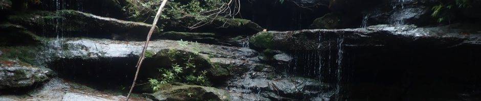
But our first small waterfall was 20m further along the creek.

And the waterfall drops into the Emerald Pool, a popular swimming hole for bushwalkers. People had been there recently, Peter found a fresh chilli on the ground, and we’d seen a lot of foot prints on the track.

Looking upstream at the Emerald Pool. We started the second part of the walk, exploring downstream in Hominy Creek.

Within about 50m we came to a big slab of rock, looked like the perfect place for aboriginal spear sharpening grooves and we weren’t disappointed. This is one of the best sets I’ve come across, there were three or four other sets on the slab.

These big slabs of rock came and went quite a bit, all on the same contour (that is we weren’t dropping down any big drops yet), very easy walking.

The slabs ended in a 30m waterfall, notes from the walk 12 years ago said to go around to the left to get down to the creek beyond the waterfall.

Didn’t take long to find a likely spot to drop down, I sent Peter and Brad to check it out.

Luckily Peter had brought along his trusty tube tape, I used it as a handline, but Janine didn’t need it.

We made our way upstream to the waterfall, and Peter and I climbed up the very slippery rocks to see if there was a nice pool at the half-way level (no pool), the rock was very slippery.

Looking down from above at the others at the base of the waterfall.

Back on track heading downstream. I have to say that I don’t remember any of this section of the creek.

It is stunning though, very pretty and easy walking, with the occasional boulder section.

Lots of orchids on the side of the rock.

Paul looking over the edge of the second waterfall.

We had to walk along about 50m to find a nice ramp down.

At the base of the waterfall, again it was about 30m.

The boulders in the creek are getting bigger now, but it was easy to find a route through.

More rock platforms, but not as extensive as before. Shortly after this we saw that the creek had widened out quite a bit and we could see fields ahead, indicating the private land, which is where we would stop.

We must be on the private land now as someone had rigged up a hammock (plus carved a sign in a branch “Pete’s Rest” I think it read. We opted to have an early lunch here before our big climb out.
Everyone was pretty happy up to this point, the creek had been really lovely and easy walking. It was only 11.45 and we’d taken our time walking down the creek (approx. 2k of creek walking). I’d marked 2 possible routes up to the ridge that we would walk out on. I vaguely recollect that it was a fairly steep but easy walk up the last time I did it. But couldn’t quite remember if we’d set off from where the private land started or backtracked up stream for 100m or so.

We opted to head up from where we had lunch, about 100m straight up over a distance of 200m, through all this fern so you couldn’t see where you were putting your feet. When we got to the cliff line I pretty much knew that we hadn’t come this way the last time.

Brad in an overhang at the cliff-line. Brad had found a bit of a dodgy climb that he thought he could do, but then Peter had gone a bit further on and found another way up. We opted to go Peter’s way, so headed over to him.

I’m not sure how Peter got up this to set up the tape to use as a hand-line, thank goodness that I wasn’t there to watch. Both Janine and I found it difficult even with the tape, because there weren’t any spots to put your feet. We all made it up though.

It was then a matter of navigating our way for about 3k to get to high point 248 where both Janine and I knew that there was a track. Unfortunately the scrub was horrible, we tried finding some rock ledges to walk along but they were few and far between.
Initially we sent Brad out ahead, and it may have been Brad that found a good ledge (or maybe it was Paul), that went for about 100m but then we were back in the scrub.

There were 3 knolls on the map that we had to cross, each of them had tricky climbs to negotiate, this cliff had a nice wind eroded cave. Shortly after this Peter tripped and hit his head on a rock. We had to stop a while to make sure he was ok, and decided then that we shouldn’t put the person with the head injury out in front.

Getting down off one of those rocky knolls.

And going up the next one, a slot that Brad thought he could get through.

And discovered that he couldn’t.
By now it’s around 3.30pm and we’ve all had enough of the scrub. It didn’t help either that there seems to be so much ironstone in the area that my compass couldn’t be relied on, the only good thing I can say about the whole afternoon is that I didn’t stuff up the navigation! And I managed to lead us to a saddle that was really difficult to find. We got to High Point 248 and looked around for the “248 Track” that is marked on my GPS map and Janine had walked on not so long ago (and I’d found 12 years ago). So, we both knew absolutely that a track led to a nice big slab of rock. Well, here we were at 248 and there was no slab of rock.
We kept on walking in the direction that we knew we had to go and low and behold, there was our big slab of rock, about 500m from the 248 high point. I remembered then that the track stops short and must just lead to where you can look over to the 248 High Point! It’s quite possible that in years gone by, the track went all the way to 248, but if it did, there’s no sign of it now. So, I’m going to amend my track notes for this walk to make sure that I don’t blunder around at 248 looking for a non-existent track again.
By now it’s 4.30 and we’re 2-3k from the vehicles, so we headed off, Peter, Janine and Paul taking off like race horses, and Brad staying behind to walk with me.

One of my favourite spots on this walk, Donovan’s Forest, a beautiful place for an overnight camp.
We were back at the cars by 5pm. I don’t know about the others, but I was stuffed, it was a good solid fitness walk, 13.5k with lots of up-hill. I’d definitely do the creek part of this walk again, but next time, maybe go out on the eastern side of the creek rather than battle that scrub again. Looking at my records, I recorded that the area burned in January 2007, so it’s quite possible that when I did this walk 12 years ago, it was after a fire, and we wouldn’t have battled all that scrub.
Thank you so much Janine, Paul, Brad and Peter for coming on the walk with me and for being so easy going about the horrific scrub!
Glad to see you are getting out and enjoying yourself.
My sister and I are going to a cabin on Lake Superior next week . I can hardly wait.
Our venture will not be as energetic as yours. More of a good book listening to the waves by day and in front of the fireplace at night!!! No hiking thru scrub!!!
Always love hearing about your treks!!
Great to hear from you Kathy and that you’re going to the lake, enjoy your nights by the fire, am envious!
Enjoyed your write-up – did some off-track walking in Popran NP last week in the search for Aboriginal sites, and the scrub is pretty thick and and unforgiving. Am thinking of an off-track route up Ironbark Creek, which I think is a bit easier going as there’s a rough track (Mailmans Walking Track) west off the Mount Olive Trail down to the creek. Did you see any cave paintings or engravings on your route?
Only the site that has been set up by (maybe) National Parks, just off the fire trail, and a few sharpening grooves in Hominy Creek.