 COLO WILDERNESS – Angorawa Creek via unnamed ridges and spurs from Grassy Hill Fire Trail – 12 & 13 August 2017
The idea for this walk started from an email conversation with Anthony Dunk after my 3 day trip to Angorwara Creek. Anthony said that he’d visited Angorwara Creek on a 2 day trip from Grassy Hill Fire Trail. I really wanted to show my bushwalking friends this spectacular area – Jeff B (trusty co-navigator), Trish M (will she walk with me again?) and Peter F (super route-finder) joined me.
The plan was to take one continuous ridge all the way to where I intended to camp. I hadn’t asked Anthony exactly which route he took in but this looked like the most logical one. The end of the ridge didn’t look so good but Jeff and I figured that we could change our mind 500m before the end and take a less dramatic route. The navigation would be complex with twists and turns on our route every 50o+m or so and we’d have to be vigilant so that we didn’t accidentally go down the wrong spur. In the end, we had one spot where we ended up on the wrong spur off a high point, but that only involved 300m back-tracking so wasn’t that big of a deal.

The trip started off at 8.30am with an incredible stroke of luck … only 10 minutes after walking down a spur (with awful scrub!) we came across an old fire trail. It was going the right way so we followed it (for about 2 or 3k), with visions of a “dream walk” and being down at the creek by lunch time! We were wondering how we’d fill in the rest of the day, laying around drinking cups of tea?

Some nice large rock slabs off to the side of the fire trail with some good views of the valley.

We’re still on the fire trail and we came across a helipad, we assume that the branches were cut around the time of the big fires a few years ago and they used the helipad for the fire-fighting choppers.

We stopped for morning tea once we got off the fire trail at “our ridge” (which diverged from the fire trail). Peter brought along morning tea, thanks Fiona for the delicious banana cake.

The Colo Wilderness and our first view of the river … it’s a long way down! Look at some of those spurs, very steep!

We’re still on the ridge, the scrub is getting a little thicker, not what we expected the ridge to be (ridges are usually easy walking). Along the way we found an umbrella in amongst some rocks, not sure how it would have gotten there. Trish was able to dismantle it to carry it out!

Back onto another nice rocky section of the ridge, Peter in the distance.

There were a few spots where we had to drop down through the rocks, the contour lines were 20m not something I’d thought a lot about up until now particularly as we were still up around 500m ASL and we would have to descend 350+m – might be very steep off the end.

Peter on an easier route down.

It was at this point that we got to an spot where we could see the way ahead and realised that I’d made a slight error and we were off course, only meant a 300m backtrack and a new bearing. Good thing that we got a good view of the way forward otherwise the error may have been compounded.

What was not so good was the scrub we had to back-track through.

By now the scrub is horrible, and there’s quite a bit of grumbling – our easy day turned out to be a lot harder after lunch and the scrub was relentless.

We’re at “decision time” now, and we decided to take an easier route down to the creek, not the one we originally chose (which looked like a lovely knife edged spur but there was no guarantee that we’d be able to get to the bottom). It was getting late and we decided it would be better to be more cautious allowing us more time to find a negotiable route. Note: As it happened when we got to our campsite (and where we would have exited off the spur), it was very, very cliffy, would have taken us for ever to find a route down.

Most of the decent was either down a scrubby slope (lots of slippery leaf litter), or down a chute such as this.

An overhang to walk through, by this time Trish is well and truly over the scrub and the slippery leaf little on the slope and she’s had enough with the buttons on her shirt which kept popping open – not sure which was more annoying for her. Trish said it was the most prolonged period of time that she’d ever been in thick scrub … and maybe exploratory trips weren’t for her any more.

This was a 3 – 4m drop which wasn’t easy, Trish found an alternate route with Peter, I siddled underneath the overhang (you can just see it in the next photo), only to have a rock that I was holding onto loosen, thankfully Peter was close enough to stop me from serious damage.

Another drop down which was easier with the tape. We kept on expecting to be thwarted by a cliff-line but luck was on our side for almost the whole way down, all I can say is thank goodness we chose the “easier” route with more options.

We’re finally down at creek level, but about 500m from our campsite, it was now around 4.30pm and the light was fading.

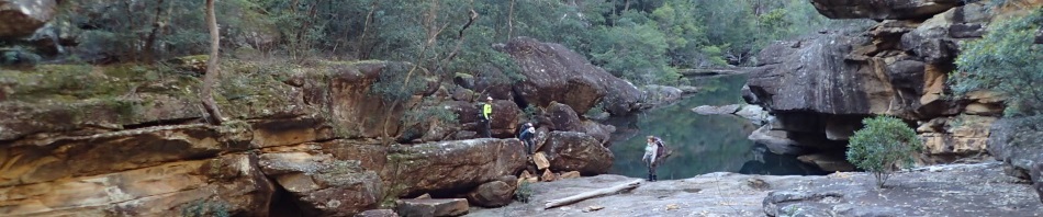
Peter and I were separated for a while from Jeff and Trish (we were on different sides of the creek), but we caught up at the start of the rock slabs.

The whole point of the trip were these amazing rock slabs in the creek that I wanted to show Trish and Peter (and see again for myself), and they were as spectacular as I remembered them! We found a spot to camp, not the spot that I had in my memory but by 5pm we were just happy to find somewhere flat! So much for getting into camp at lunch time and laying around drinking cups of tea!

Tents, hammocks and tarps erected, cleaned up, billies boiled and dinner out of the way, Trish brought out fresh strawberries and chocolate dipping sauce, and the strawberries weren’t even squashed after her pack had been tossed around!

I woke everyone at 6am next morning with the plan that we would take a walk downstream for an hour before breakfast, after all, the whole point of the trip was the 1k of creek and rock slabs down to the Colo.

Lots of climb downs and some rocks to scramble under/over

Looking upstream with three small cascades, boy the creek was a lot different from the last time (when it was, if not in flood, close to it!)

Lovely reflections, perfect weather

Breakfast out of the way and we’re on our way upstream (our campsite was about 50m downstream), we had about 2.5k to go to our planned exit route up a spur and yet another ridge.

We endeavoured to keep dry feet for the whole of the route which meant some scrambling in places. It wasn’t that we were precious about our shoes, but the rocks were very slippery.

Peter made it across this ledge with his pack on but decided to get down to the next level to take our packs because it was a little hairy (with a pack on).

Jeff where Peter crawled through with his pack on (I think he’s telling me he doesn’t like crawling along ledges like this … it wasn’t like he’d fall to almost certain death or anything).

A bit of sidling, the rocks below looked ok in the photo but they were all very slippery, we’d had a number of slips already.

Nice reflections

We accidentally passed the side creek where the camp cave is (where I camped last time) and couldn’t be bothered back-tracking to it. Interestingly, we were now encountering branches which had been sawn off, and evidence that our route was a worn foot-pad. One sawn branch even had green leaves (still fresh) attached to it which I’m assuming was from a cut someone made last weekend. We were now in Adderley Creek and decided to continue following this marked track (past the point where we had intended exiting), with the hope that it would lead us to a good, tried and tested exit route.
Eventually the “marked route” brought us to a side creek and a tree with an old pink tape around it. We couldn’t find any more cut branches (ahead or to the side) so figured this must be the exit point that the person had taken, why else would you mark it? However, on the way up, and on the ridge, I didn’t find any more sawn or snapped branches, so figure the route must have continued upstream. But, as we continued along the ridge we couldn’t see where the person could have accessed our ridge … it’s a mystery.

We had lunch at 1.30pm about 100m from the top (all up a 300m climb). We popped out where I had planned to access this ridge, we’d just approached it from a different angle. It was definitely a great route the way we came (my thanks to the person with the pink tape). Once we got up to the top, we took time out to check out the way forward, by now it was around 2.30pm.

Amazingly, this ridge was what we would expect of a ridge in this country, rocky slabs and not too much scrub to push through. The ridge on the horizon is the one that we’d walked out on the day before.

For close to 750m the ridge was only 10 – 20m wide with 20 – 30m drops (if not longer) either side, on the right hand side (which is where we would have approached from) it was almost vertical cliff with no way to access it. The scrub thickened up about a k from where we hoped to access the fire trail we’d walked in on, but again, no evidence of sawn branches and with such thick scrub, if the guy with the saw had gone this way, he would definitely have blazed a trail!

We’d had a dream run all day with no errors in navigation, despite many twists to the North, then to the North-east, then North again! Once on the fire trail though, I became disoriented and convinced everyone that we should turn right, we walked for 150m and then the fire trail disappeared … so we retraced our steps and eventually came to the spot where we’d originally left the trail. I still wasn’t convinced we were going the right way, my internal compass was way off!

The wattle was starting to put on a good display, here are two different varieties.

We didn’t get back to the ute until 5pm, cleaned up and then headed to Windsor to eat too much and reward ourselves with a drink.
… and here are the stats (thank you Jeff) …
Total moving time 9hrs (considering it was two 9hr days we must have sat around a lot!)
Average moving speed 3k/hr (about right, we were “smoking” on that fire trail)
Distance covered 27k (that doesn’t sound right, I thought it was more likely 19k)
Elevation, not much probably around 400m
It had been a bigger weekend than expected, but I’m really glad I did it, never have to go back again though. Thanks Trish, Peter and Jeff for coming with me.
So..almost an epic….
haha! but almost a dream walk too! Nah, was never in danger of being an epic, although if I’d taken them down the spur I first though about going down, yes that would have been an epic.
Nice walk M lots of scrub and some nice rock formations. Got lots of rock formations for you to check out when we get home
Love Greg
Looking forward to it, when do you get back?