 COLO WILDERNESS – ANGOWARA CREEK – JANUARY 2016
Drip Rock Fire Trail > Angowara Creek > Colo River > Clews Cave > Drip Rock Fire Trail
I had read about a trip years ago to the bottom section of Angowara Creek which had lovely large flat slabs of rock that made the creek walking easy, it had been on my bucket list for years and with 3 days at our disposal, seemed like the right time to do it. I had done a lot of networking for this trip with some contacts that knew the area well, so had been given some inside knowledge about where to find some points of interest. Heather R, Steve R, Steve R, Geoff R and Trish N thought the trip sounded good so signed up for it.
 There was a little rain forecast on Friday evening, but the rest of the weekend looked good. Jeff and I headed out at around 3pm from the Central Coast, hit the usual traffic, did some forward planning and said if it was raining at Windsor we’d stop at the pub, have dinner and then when the rain abated we’d continue on to Drip Rock Fire Trail, I had seen photos of where people parked their cars and it looked good enough to camp the night there. We hit Windsor and there was no rain so continued on for the Colo Bridge, about half way there, the rain started and it bucketed down, I mean it was like the 40 nights and 40 days of rain and then some! We forged ahead regardless, with the plan to find the fire trail, even though we could hardly see 10m in front of us.
  We had a grid reference which was needed as for the life of us we couldn’t find a fire trail that looked very well used. Eventually we backtracked a few times and there it was, it went down a small decline and was a raging torrent, no way were we going down there.
Plan B, we had a bit of a think about it, two other vehicles were on their way up to meet us and camp for the night. Luckily we had mob reception so called them and told them to meet us at the Bob Turner Track, we knew that at the end you could set up a few tents as a last resort. We then back tracked to Bob Turner’s Track and actually found a half-way decent spot that was flat and not on the road, needed a bit of gardening but we had the time to do that before the others arrived and by the time they got there we had a nice fire going.
 We were up bright and early next morning and backtracked to Drip Rock. The raging torrent was gone but the fire trail was a bit average. We took the Colorado down it, sussed it out to see if we could get any further then went back for the others. Eventually we found ourselves at the locked gate, saddled up and started off up-hill. We walked along the fire trail for a while and then set off cross country. The scrub was relatively friendly and the going was pretty easy. We skirted around the top of some minor side creeks and did a little rock scrambling (always fun).
 Even though the day was overcast the humidity was really high and we were sweating like pigs in no time at all, and we were drinking lots of water. The side creek we were heading for would definitely be welcome. I have to admit, given the amount of rain the night before I was a little apprehensive about the level of the water in the creeks and the river, so I was keen to see how it was. If the water level was too high, we may have to retrace our steps.
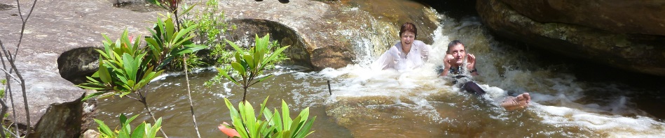
Eventually we found the gully we were looking for and made our way down coming out at a lovely little cascade, water was pumping but there was still no way to determine whether it would be too high downstream.  Heather and the two Steves decided that it was time for a swim and frolicked for a half hour or so recovering from our epic descent. I have to admit that the waterfall looked inviting, but I was keen to find the aboriginal art that we were looking for.
When you plan a walk, there are usually things that you want to achieve, this one had a few (1) find the side creek – done; (2) find the aboriginal art – I’d be disappointed if we couldn’t;  (3) find the overhang to spend the night – campsites may be scarce; (3) find the next set of aboriginal art; and (4) get to the Colo and see if we could continue downstream. So, here we were at the side creek, where was the art?
I virtually skirted around the waterfall and walked up into an overhang and there it was, Dingo’s Lair, charcoal drawings of dingos across the back wall of the overhang, spectacular!
We spent quite a bit of time photographing the art work and then headed downstream to find the cave for the night.
The going downstream wasn’t easy, we stayed high on the left hand bank and it took far longer than I had anticipated, it was getting late and I was starting to get nervous about  where we’d camp, the sides of the creek were very steep and there wasn’t anywhere to pitch a tent. After about 3 hours, we finally could see a junction and I hoped that that was where our cave would be, I didn’t have any idea of what side it was on or how far from the creek it was but as it turned out I need not have stressed, the overhang stood out like the proverbial dogs balls!
 I’ve never been so pleased to arrive at a campsite. We set up for the night and busied ourselves with dinner, after which we brought out the cards for our traditional game of May I? We’ve been playing this card game on a fairly regular basis since a trip to Morong Deep a few years ago when I “supposedly” spilled my wine all over the cards because I was losing (not true!).
  The kids played cards for a while, I went to sleep, I was stuffed!
Next morning we headed down to Angowara to see what the flow was like, it had had time to go down a little in the last 36 hours so hopefully all would be good and by the time we got to the Colo, we’d know whether we could forge ahead, or we’d have to find an exit route out.
 The first part of Angowara was a little scrubby and I was beginning to think that we’d never come to the big rock slabs and then, there they were, everything that I’d imagined they were … with a bit more water than I’d expected. The lower section of the creek definitely warrants another trip, in summer when you could take advantage of the lovely pools. There are towering cliffs all around and good campsites. We found where the hand stencils should have been in an overhang (just near a nice campsite), but if they were there years ago, they weren’t there now, which is a shame.
 There were lots of big slabs of rock that I expected but there were also sections where we had to scramble around or climb down through shutes, just the sort of stuff that we like to do.
It wasn’t long before we were at the junction of Angowara and the Colo, we stopped for lunch and weighed our options. The river was probably about a metre  higher than the last time we’d been on it (and it was low then), it was flowing fairly fast but definitely wasn’t in full flood, at least we could see the rocks poking out of the water, in full flood they’d not be there! We dithered around for a while, will we or wont we? If we went downstream we were committed at least until the next exit route that we know of. If we didn’t go downstream the options weren’t great, exit where we
  were (a difficult climb out) or retrace our steps).
We all talked it over and agreed that if we crossed the river there was no going back. Everyone seemed cool with that, so we walked down to the edge, and launched ourselves. It was good in the fast current, but not good when you got in an eddy, eventually we all got across and regrouped, and that was what it was like for the rest of the day. We walked around the rapids but on the downstream side, launched ourselves in the river and got a nice quick trip downstream, then the first person to the rapid would get out and make sure everyone else was out of the river safely before the rapid. In no time at  all, we were down at our next campsite, opposite Pass 28a (and a potential exit route). We set up camp and and got a big fire going to dry ourselves out. We had happy hour, then dinner and out came the cards again!
Next morning we agreed that we would head down to our exit point and reassess the position, camp for the night at  the bottom of Pass 28 or forge ahead and go to Clews Cave for the night. The trip downstream was relatively fast and we were t Pass 28 by lunch, it was good to know that we didn’t have to do any more river crossing, but I wasn’t looking forward to the climb up to The Island. We debated whether or not to camp on the river for the night and finally all agreed that we would set out. The route up to The Island was relatively straight forward but instead of going up and over the top of it, we skirted around to the east of The Island, in hindsight that wasn’t the best option, it took us forever to get to the spur that we needed to take to get to Clews Cave. None of us had been there before but it was a well known route so we figured “how hard could it be?”. Eventually we were at the spur and the way down was dead easy (thankfully), we hit the creek and found Clews without any problem. I had heard that water wasn’t reliable there but after all the rain we had no problem. We didn’t camp in the cave but found a nice flat area above it where we could all spread out. It had been a big day and we were all pleased to finally have a fire, dinner and go to bed.
 From here on it was straight forward, we picked the most direct way back to Drip Rock Trail and had no issues. The only interesting part of this was a track that had been made from one of the high points all the way to the fire trail, it looked as though chain saws had been used and there were heaps of tags all over the place. The cut trail went for perhaps a k, and Trish and I debated whether or not we should go back for a day walk to see if we could find what was at the end of the “track”.
We were back at the vehicles by late afternoon and Heather got out the cold beers from her fridge (in the car), the beers and packs of potato chips were just what we needed to end a perfect trip. Great company, an amazing adventure and we were all uninjured, life doesn’t get much better than that.
(NB: If you read through this post on the walk, you will notice that I haven’t quoted any place names or the actual route that I took. This is intentional, the notes for the aboriginal art work were kindly shared with me, but I don’t believe they’re published anywhere and even though images are posted on the net, the location isn’t, so, I will leave it that way but that doesn’t prevent you from exploring the area yourselves, you may be lucky).
Pingback: A Dream Walk … almost! | Adventures with M