 Baal Bone Gap > Baal Bone Point > Pantoneys Crown > Crown Creek > Point Cameron > The Pondage > Mt McLean – 1 – 3 October 2016
I’d been planning this walk for quite a few years, just waiting for a 3 day weekend to do it, and when I thought about it, it didn’t sound all that bad, a couple of ups and downs, how hard could it be? Well, I think I’ve just done my last Pantoneys Crown walk!
Jeff B, Trish N, Heather R, Ed and Jo S joined me – none of them had done Pantoneys Crown before and I had told them it was a classic walk (which it is!), plus I was avoiding the horrid fire trail walk back to the cars by going over to The Pondage, in hindsight, the fire trail walk may have been easier!
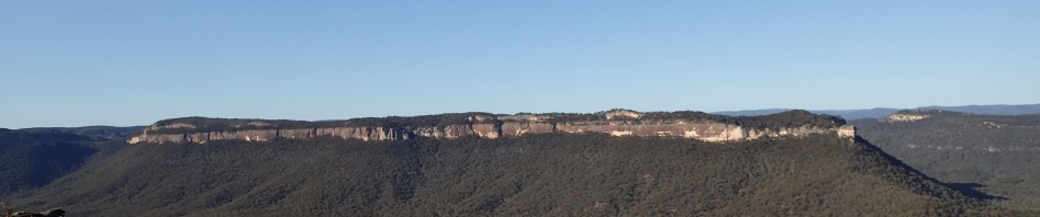
We met up at 8.00am and set off in gale force winds (well, maybe not gale force but it was extremely windy). We walked down the Bicentennial Trail (leaving the cars out near Mt McLean where we’d finish the walk). These days the Bicentennial Trail is very eroded from 4WD vehicles out having fun. After about an hour of walking we were at a high spot on the trail where we set off cross country to the start of the plateau that we would walk along to the end (see the banner shot of the plateau).

Nice easy open country to walk in (Heather and Trish)

Lots of pagodas to walk up and over

Our first glimpse of Pantoneys Crown, we would walk up the spur on the left end and then down the spur on the right end
Before long we got our first peak at Pantoneys, our destination for the night. Walking along the plateau is fairly straight forward, you just stick to the cliff-line, but this lulled me into a false sense of security and I missed a critical turn, going about 200m further than I needed to go. Fortunately, Jeff saw the error of my ways and pulled us back to the spot where I should have turned.

Finally we were at the end of the plateau, this is the narrow section of rock where the pass is, just behind the rock in the middle that looks like it’s just hanging there.

Getting to the chute involves stepping across a bit of a gap between the two rocks, best to sit on your butt to cross, then you have to walk around a very large rock on a 50cm Ledge of Death, with a big drop at the side, I don’t look so have no idea how high it is, but it’s seriously scary.

After the Ledge of Death, there is a chute to scramble down, it was slippery after the rain.

Then there is another slippery chute ending in a very old dodgy log, it’s a relief to get to the bottom.
We lunched out of the wind in a cave at the base of the cliff-line and then headed down on a footpad to the saddle, making sure not to veer off to either side into gullies (which I’ve done before).
The footpad ended at the saddle but it was basically follow your nose to get up the other side to the pass to get to the top of Pantoneys. Now, this is the fifth time that I’ve done this part of the walk, and I certainly don’t remember it being as steep as it was on this day, it just never seemed to end and by the top was almost vertical, Trish (who was walking with me) and I looked down and couldn’t believe what we’d just clambered up, both of us were feeling less than average by the time we got to the top. It was now about 3.30pm and I’d estimated that it would take us an hour to get up through the pass which involves a lot of scrambling.

Trish starting to make her way up the pass

Jo and Ed, still going up the pass, amazing coloured sandstone on the cliff-face

Trish and I both called for the tape here, it was just too pushy for our small legs to get to the first ledge, plus we were stuffed, despite there being lots of hand holds, the first section was daunting!

Almost at the top here, and another difficult scramble

Jo on the rock scramble up the pass, she was really enjoy herself!
We pack hauled most of the way and got the tape out a couple of times to make the climb up easier (mostly for the benefit of Trish and me), I remember the last time I did this pass I had to use a tape too, for a short person some of the climbs are just a bit too high. Finally, at 4.30pm we were at top, Trish and I were extremely thankful for the assistance we were given and for the pack hauling that everyone did.
We dropped packs at the campsite and set off to get some water before dark. I couldn’t quite remember which gully had the water in it and after two false starts we found it, was obvious once I saw the vegetation. With the recent rain I was pretty confident that there would be water in the mini canyon and thankfully the soak was flowing and there was more than enough for our purposes. Jo made the campfire while we were getting water and after dinner we were all in bed pretty early after such a big day.
And, just to prove I was there, two photos of me!

Me on the last 2m climb up, everyone else made it up without the tape, but I decided, enough was enough, I feel bad that I didn’t call for the tape for Trish, it’s a nasty climb! (photo: Trish Neil)

Retrieving the tape (photo: Trish Neil)

Jo and Ed around the campfire – this is the campsite that most people use.

Our campsite, sheltered from the wind amongst some pagodas, lots of firewood and plenty of flat spots for tents.
We were up at the crack of dawn on Sunday and the weather was perfect, a bit of wind to keep us cool, and glorious blue skies. For the next part of the adventure, we walked along the top of Pantoneys Crown to the pass at the end that I favour (there are a couple of passes there but this is the easiest for me to find).

Jo and Ed walking through the heath, thankfully there’s a well trodden footpad most of the way.

Lots of rock to walk across, pagodas either side, but very easy walking.

Walking along the cliff-line, this rock looked like a face with a nose and a mouth, the Capertee Valley in the distance

Heather down-climbing at the pass off the end of Pantoneys
The fixed rope (admittedly a bit dodgy) had been removed so the tape came in handy. I sent Jeff down first so that he could spot me (tell me where to put my feet as the foot holds aren’t obvious). Not everyone was comfortable with the down-climb but we soon following a footpad. I had forgotten about the next two awkward climb-downs that soon followed and out came the tape again. Finally we were at the base of the cliff and the white sand cave that I’d remembered from past trips. We had morning tea and then set off down on the footpad. After 15 minutes or so, I determined that we were on a spur that would take us way out of our intended path so we traversed along until we hit the next spur and started down this. It was relatively straight forward, but you needed to keep an eye on your bearings because it was very easy to stray off to one side or the other and find yourself going in the wrong direction. Fortunately we only had one small diversion and we picked this up after only 100m or so. It was very, very hot and we were all thankful to finally reach the creek for lunch and a rest in the shade.
None of us were keen for the 300+m climb up to Point Cameron. Whilst the terrain was steep for the start and at the end, in the middle there was a lovely section that was wide open and surprisingly flat. Trish and I dragged ourselves up the steep spur at the end, taking heaps of rests, but it was very hot and by the time we got to the top we were stuffed.

Jeff starting the climb up the Point Cameron pass, whilst it looks easy, there weren’t many places for your feet!
Whilst Jeff and I had done this pass before quite a few years ago, it didn’t look familiar but Jeff, Heather, Jo and Ed started up and managed to scope out the route and Trish and I followed after a bit of a rest. It took quite a while for us to all get to the top, probably because Jeff and Ed helped out by bringing up the packs for Trish and me (there has to be some benefit for leading trips). It was at this time that my trusty new Olympus camera’s battery died … that’s what you get for buying a camera on Friday morning, not charging the battery and taking it away for the weekend, I do love the photos though!
Up the top, the terrain got very messy and what I remembered as a straight forward route to the Pondage, was pretty much a nightmare, pagodas all over the place and impenetrable scrub. It took way longer than expected but we were in camp by 4.45 and hurried off to pick up water from the little canyon. This too was flowing (unlike the last time I’d been here when it was bone dry last October). Another great night around the campfire, most of us salivating over Jeff’s Steak Dinner!
The wind picked up during the night and there was a smattering of rain, so the originally planned 10am departure was brought forward to 8.30. This was a good idea as, by the time we got to Mt Davidson, the rain started with a vengeance. We set a cracking pace and completed what is usually a 4 hour walk back to the cars in 2 hours, mind you there was no scenery to enjoy, we were totally in cloud, rain, mist and we were all really cold.

Crossing the Moonscape Rock platform in the rain/mist, visibility was about 100m
So, I’ve finally done this walk that I’d planned so long ago, and thank goodness, because I sure as hell wouldn’t be able to do this in the future, just too big. But, it is a brilliant walk, just the right amount of challenge with the climbs up and down and fabulous scenery … the truly sad thing is I know of someone who is doing the exact same walk in 2 days … bastards, just too fit!
Wow what a great trip. I’m exhausted from just reading your report. Well done to you all.
You’re tired, imagine how I feel! yes a great trip.
Thanks Marilyn great trip and 2 hours to walk out from The Pondage has to be a record
Yes, has to be a record, but now we know it’s feasible, it opens up a range of other walks in the area eh?
Hi! We are up on pantoneys now, can you tell us where the mini canyon is
Sorry, I’m down in Tasmania caving and only just found your comment. Hope you found water!