 Exploratory walk – looking for an unpublished canyon – Newnes Plateau.
I’d had 10 days cooped up in the house and finally decided I needed to get out, Lindsay B and Trish N joined me to suss out where this unpublished canyon that I’d “heard about” might be. I knew the “general area” and pouring over the map I’d picked out a section of a creek that looked like it might be interesting even if a canyon wasn’t there. We all had plans for Sunday, so set off for Newnes State Forest at 5am on Saturday, we were back home by 7pm (what were we thinking, long way to go for a day walk!).
So, what did we find … the fire trail that I had seen from the other side of the valley (and was marked on the 2nd Edition of the map) was easy to spot, it was signposted off the Glow-worm Tunnel Road. We followed it almost to the end but I pulled the pin on going any further when it started to go seriously downhill with “steps” that the CX5 wouldn’t be able to handle. As it was I was on the edge of my seat driving down 2 very rocky sections of the fire trail, I’m not used to 4wd tracks, and I tried not to think of driving back up! Anyway, we parked the car and continued walking down the fire trail.

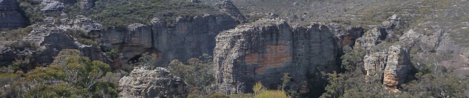
The first big pagoda as we walked down the fire trail, we scrub bashed over it to see what was ahead, and if there was a likely route down into our creek, avoiding what would be scrubby upstream.

Lindsay making me very nervous at the edge of the Big Pagoda – no route down there!
The scenery was stunning, pagodas everywhere and massive flat cliffs. We saw a likely route off to the right and went back to the fire trail and walked another 200m and then set off on a bit of a spur. We got to the end of that and looked down, no way we were getting down into the creek from here.

After a bit of scrub bashing and back tracking we made our way to the edge of our creek and could look down into it and hear the running water, this was the only part that had a negotiable route down, so we decided to give it a go.

Trish heading down into the creek, on a route that we could easily get back up.
We were in the creek and there was plenty of water although it kept going underground and then reappearing, there were a couple of deep pools which looked like they might be permanent.

Walking downstream, the water in the creek kept going underground, there appeared to be a route through the ferns, looked like someone had trampled through them in the past six months (no new spring regrowth) and it wasn’t an animal pad.

Eventually we came to a 2m drop, through a very narrow constriction. You can see the pool at the bottom. No evidence of rope marks, no slings and the moss hadn’t been disturbed by careless feet.
So, we’d found a canyon but we were going to have to go back with ropes and gear to go any further. We sussed out what trees we’d use as anchors, the one in the creek into the pool below isn’t really big enough (only as bit as my wrist), so we’ve decided on one up on the ledge, hopefully it’s roots will not be just on the surface! This isn’t a bad thing as the other drop was nice and mossy and it would be a pity to disturb the moss.

We hadn’t bought abseil gear so the drop stopped us in our tracks. We climbed up a bit of a ledge and walked along it looking for a route down (here’s Trish retreating after a fruitless search).

Retreating upstream to exit, you can see that the vegetation is largely undisturbed, so whoever went down there recently, either they didn’t continue on, or it wasn’t much of a canyon to warrant repeating.

Lindsay making his way up the exit ramp.
We retreated back to the fire trail and wandered down to the end to see what else we could see. It looks as though 4wders go down to the end and camp (there was a big fire scar), and there’s a well worn track out onto the two pagodas that are on the edge of the cliff. We took the time to walk out to the edge and take photos and found a plaque … Lurline Jacks 1924 – 2007.

At the end of the fire trail, looking across to our proposed exit route, up the gully beside the big cliff face, a known route.
We then went back to the car and drove around to the other side of the creek which will be how we’ll exit. It will involve a 1.5 hour car shuffle by the time we position a vehicle and then retrieve the one at the start, but in the scheme of things that’s not too bad.

On the other side of the creek above our proposed exit route, the area we’d explored in the distance.
We walked down to our proposed exit track and looked across the creek to see what the end of the canyon was like, a few big trees but doesn’t end in a bloody great cliff, so that’s a bonus.
I think we’ll have to go back for Stage #2 and go down our exit route to make sure there are no waterfalls/cliffs between our canyon and the exit route, that would really spoil the adventure if we couldn’t get out! Big thanks to Lindsay and Trish for joining me on this adventure, they were the perfect exploratory partners. Stay tuned for Stage #2!
Full of admiration M
Hope to join you one day BUT on a more leisurely adventure!!
SnP
Nothing admirable there Shirley, couldn’t do it without support from my bushwalking friends going on my hair-brained adventures! You going to NZ with DS & JV?
Marilyn and leisurely adventures never go together!!! 🙂
Ah, for Shirley (and you!) I’d make a point of doing leisurely! Besides Jen, am getting on in years, surely I should be leaning towards leisurely.