 WOOLPACK ROCKS #3 – MAY 2016
Unnamed pass > Newnes Plateau > Collett Gap > Red Rocks Creek > Woolpack Gap > Collett Gap
This was our 3rd or 4th trip to Woolpack Rocks (depending on what you counted) and our 3rd trip down to Collett Gap, we knew what terrain we were looking for and when we dropped down into a pass, we convinced ourselves that the cave we saw was the one we had seen three times before. Not!
Last October, when we did a walk from the Plateau over to Cape Horn via Woolpack Rocks (which is a whole other story), I determined that I needed to go back to Woolpack Rocks to see what was beyond our campsite.
This trip didn’t start out well for me, we drove up to the Donkey Mountain car park on Friday night and I stayed up too late around the campfire, then when I went to bed I was freezing and swear that I only got an hour’s sleep, I was shivering half the night, and no wonder, next morning the tent was iced over inside and outside! So, I was less than average starting the walk.
 We got off right on time at 9am, and Jeff B, Heather R, Trish N, Brad M, Cathy B and I started off up the unnamed spur which would give us access to Newnes Plateau. The climb up was long and tiring, we took plenty of stops but the spur never seems to end.
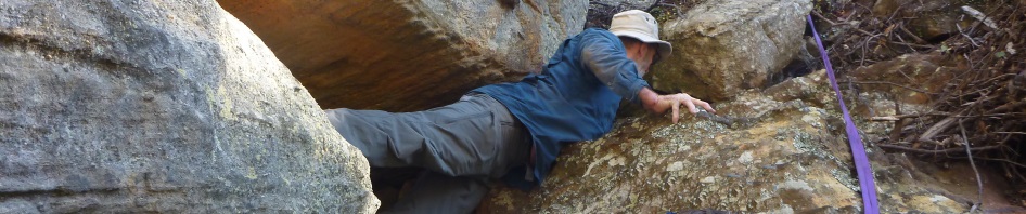
Eventually we were up at the cliff line and traversed around to the right to a slot which would take us to the first little climb-up. Brad scooted up and set up a hand-line which some of us used and we also used to pack haul.
 Then we skirted around to the left of the cliff-line to our next climb-up, which once again Brad led the way (go Brad!). We were soon up the top of this climb and then it was a small ramp up to the top, the pagodas and amazing views down into the valley and looking across at Donkey Mountain.
 It was then simply a matter of traversing over to the pass which would take us down to Collett Gap. We’d done this route 3 times before and each time we were too far to the left of the pass and had to walk around to find it. This time we weren’t going to be sucked in to going too far to the left, so we took a slightly different bearing. The vegetation didn’t look familiar, but we scouted around for about 15 minutes and then Jeff and I both came to a ramp that looked familiar … going down between 2 pagodas, casuarina trees in the ramp and it dropped down to a cave on our right (where we’d had lunch 3 times before). So, we called the rest of the group forward. It was 12pm and we thought we’d continue on to Collett Gap for lunch. When we arrived at the cave I took a look around and said this doesn’t look like the same cave. The ground below it didn’t seem to slope down as much as I expected,
  plus the cave looked a bit too small, it was level like the one I remembered but something just wasn’t right about it. Anyway, I discounted all my negative thoughts as “bad memory” and we decided to continue onwards, we didn’t drop too far down (as luck would have it), but skirted around, almost on the level of the cave. This wasn’t looking good, I felt we needed to be down below the cliff-line. But, we continued on, eventually coming to a finger of land that went out into the valley (looking down to where we should have been). We thought we’d just find a way down through the cliff-line and get to the base of the cliffs, where we should have been. Trish went forward scouting for a route down, after 15 minutes, she called out that she was unsuccessful and so we retreated back up the small spur to the top again.
We re-grouped to have some lunch and consider our options. It was close to 1pm and if we didn’t get to Collett Gap by 2pm, we’d have to turn around and head back to the cars (we knew from previous experience how long it would take to get to Woolpack Gap and anything after 2pm was cutting it too fine with the limited daylight hours).
Jeff consulted the map and gps and then took off to scout around. He was gone for about 15 minutes and when he came back announced that he could see the saddle we needed to be on, and it looked like an easy route down. I had concerns that we’d hit another cliff-line but we decided to give it a go, worse case was that we’d have to back track and return to the vehicles if we didn’t make the Gap by our 2pm deadline.
So, we headed over to this nice ramp down and as I’m descending I’m thinking gee this looks familiar, I called out to Jeff “Is there a cave there”, and when I got to the bottom there they were all standing in the cave. It was the “real” cave and this is the pass we should have gone down an hour ago. When Jeff had gone down to scout around he hadn’t seen the cave at that time! Believe it or not, it was almost identical to the cave earlier in the morning, just a little bit bigger! It was a really good thing after leaving the first cave that we hadn’t dropped down into the creek because it would all have gone hideously wrong, we would still be in that creek system looking for Collett Gap (no we wouldn’t, but we would have run out of time and had to go back to the cars!).
So, we’re back on track, it was a mere 100m or so (not as far as I had remembered it) around the base of the cliff-line on a well trodden track and we were at Collett Gap right on 2pm. We didn’t waste any time and headed up the small hill after the Gap and then traversed around, heading one creek on the right and another on the left. The only hick-up we had was when Jeff was out in front and I lost sight of him for a while and we ended up in bush bashing scrub but it only lasted 10 minutes or so, then we were out, regrouped and on our way to our next pass down into a side creek of Red Rocks Creek.
 We arrived at the head of the Creek and found a way down, not the way down we’d taken the last time and it involved a bit of a slide in a couple of places, but we were all down, I looked back and 100m to the right was the way we’d gone down back in October, at least I recognised that spot for our return journey as it was an easier way up.
We walked down the side creek and eventually came to a waterfall and found the pass around to the left which took us down into Red Rocks Creek (this has cairns so is a pass well used). We walked upstream for about 30 minutes and then some walked up Marilyn’s Creek (that’s another story) towards the water hole and the rest of us walked up a small spur and onto the ridge where we would be camping, arriving at camp by 4.30pm.
 Thankfully there was water in the water hole (although less than the last time), so we set up camp, we were all too tired to play cards so were early to bed (except Heather who’s our night owl).
Next morning we woke early and (with the exception of Cathy) headed out to see what was beyond our campsite, I suspected there were other ones on the small ridge and we did come to a good one with a couple of camp caves and a few pagodas (I’d probably use this one in the future, although you would have to cart water from the previous campsite as the water hole is right below it). We walked all the way up to Woolpack Gap and then skirted around to see if we could get to Woolpack Rocks (even if you could, we didn’t have enough time). So, we headed back to camp to pick up Cathy at 10am and start our walk out.
We walked downstream in Marilyn’s Creek until we got to a junction and then headed up on the right hand bank. There was a bit of a footpad which became more and more obvious the further we went. We then came to a point that Jeff had spotted yesterday and had thought it was a route up through the cliff-line. He, Heather and I scouted up this route and it definitely looked like a footpad, there were no cairns around, but that’s not always an indication of a route others take.
 We went back to the others and told them we’d like to try this route up through the cliff-line and let them know the possibility that we might have to come back and continue around to our known route. They were agreeable so up we headed. It was a really good route, no climb ups, ramps all the way, and probably cut about 1/2 hour off our return journey.
We were soon up the top and heading along to our inbound route which is relatively straight forward. Having left our campsite at 10.00 am we were back at Collett Gap for an early lunch at 12.30pm and started walking again at about 1pm.
 We’d used this route down Collett Gap twice before, the first time there was no track, the second time it was right on dusk so we wouldn’t have been able to see a track. This time there was a well worn track down (thanks to The Book which has published this route). It was quite degraded, and I expect that with the next heavy rain, a lot of the soil will be washed downstream in the small creek.
 When we reached the base of the cliff-line the track became indistinct so we were off on our own route now. It’s a tedious 2 hour walk back to the cars, up and down gullies, trying to skirt around properties and their fence lines, and more little hills than you want. The only thing of interest was a stand of dead sapplings with this amazing yellow lichen on the trunks!
We were back at the cars just before 3pm, the others headed off for Pie in the Sky where we were all to meet up for a coffee, Jeff and I sat on the back of the ute with beers and potato chips, doing a post mortem on the trip (what we did right and what we did wrong!).
 Well, another trip off the Wish List, I had said I wouldn’t go back to Woolpack Rocks and this was my trip to see what was above the campsite (to make sure I hadn’t missed out on something spectacular). On walking out though, I did say that I wouldn’t mind doing the full traverse, Newnes > Little Capertee Creek > Mt Dawson (camp) > Woolpack Rocks (camp) > Hughes Defile > McLean’s Pass (camp) > Cape Horn, it’s a solid 4 day walk, and based on past experience, only to be attempted with the assurance of water in the water holes!
Another memorable adventure I think we should go back I’d like to spend a night in that 1 person cave looks like a cosy spot.
Jeff
Well ….. I was thinking, if we do a trip Mt Dawson > Woolpack Rocks > McLean’s Pass > Cape Horn, we wouldn’t have to take tents/flies, there are camp caves the whole way! you just better decide to do it sooner rather than later AND after rain!