 DEUA NP – 26 January 2024
I had this vision of an archway in the creek made out of white marble and a track going through it, the reality was it was nothing like that! I’d visited The Big Hole and Wyanbene Caves in 2015 and 2014 but had never taken the time to do the walk down to Marble Arch. When I finally did it this weekend, it more than met my expectations, what a great walk, and there’s a cave there!
I’ve been hovering around this NP since 2014, always wanted to see more of it, but it’s full-on wilderness in most areas, except for the two tourist areas on the northern side, The Big Hole/Marble Arch (accessed from Berland Camp ground) and Wyanbene Caves (at least that’s how I envisage the NP, might be wrong though).
CSS had organised a trip to Wyanbene and when I said I thought I’d maximise my time down there (it is after all a 4.5 hour drive) and do the walk to the Arch, John B said he’d go with me (along with Liz McC and Alan S).
I left home at 5am and picked up Liz at 7am then met up with John B and Alan S at Berland Campground at 11.00am to start the walk.

It was actually a bit of an adventure getting to the campground for Liz and me, first of all my SatNav took us down a dirt road that didn’t look right to us, so we stopped a passing motorist and got the good-oil go back and stay on the tarred road for a few more K. Then we passed this turnoff, someone had taken the brown sign off the poles (this is a previous photo that someone had taken before the sign was removed). We suspected we’d gone too far, then engaged Liz’s mobile phone, figured out we had to turn around and retrace our steps and see if Berlang campground was at the end of the road, luckily it was!
It’s noted on the NP sign as a 12k round trip, but others seem to think it’s only 10k or 11k. Starting at 11am we had plenty of daylight hours to do the walk and have a poke around.

The start of the walk is from a campground, 50m on a track and then you have to wade across the Shoalhaven River (Liz putting her shoes back on after the wade – about knee deep).

The track, which initially goes to The Big Hole then continues on to the Arch, is very well defined … up hill all the way to The Big Hole. The track has had a substantial amount of work done on it and there were very nice steps on the up hill sections (made the downhill return walk much easier too).

Looking down into The Big Hole from the viewing platform. I still find it hard to believe that I abseiled this and then prussiked out.

Looking across at the spot where we rigged the ropes. We set up one of the ropes between these two trees in the middle, with a big roll of hessian to stop us dislodging loose rocks.

After the Big Hole, the track drops down about 50m in elevation and then it’s open bushland, easy walking but quite a few small gullies to cross (making it an undulating track – why couldn’t they keep on the same contour to make it flatter LOL).

At the top of the spur that would take us down into the Reedy Creek Valley, that white patch you can see is limestone. It was around about here that we saw our first leech, I’m afraid that I’ve traumatised Liz with our visit to the Wattagans and Leech Creek (aka Wallis Creek).

After dropping about 50 -100m of elevation, we’re in the creek, turned right and walked about 30m towards the cave – so far no further sightings of leeches..

Going into the cave to have a look around. I wasn’t expecting a cave. And there wasn’t really an arch-way, it was more like a tunnel. We donned our head torches for the cave (should have brought helmets too) and John showed us the features of the cave and where the side passages were, I’d say if you had a full day to explore, you could do the cave justice, as it was it was a quick in and out!

In the cave.

We’re heading down the creek now, towards the tunnel (aka the Arch). Looking back upstream.

Looking downstream from where we had our lunch (away from leeches), from here on is a section of canyon.

The guys were trying to keep their feet dry, no way I could bridge this section, so I just got my feet wet and walked through the streamway.

More of the canyon, the rock is limestone and in much of the rock you can see big white pieces of marble in the red rock (I’m sure there is a geological description of the rock but I don’t know it).

At the end of the canyon section, there is an eflux – that is water that’s coming out of the cave stream passage, it’s a full on waterfall and if it was a hot day you could sit under it.

coming back up the canyon section.

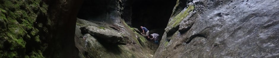
Alan and John getting down from a ledge that they walked on to get to the eflux. Gives you some perspective of how big the canyon is.

Alan bridging and keeping his shoes dry, I like this photo as it shows you how green the mossy wall is.
After we’d had our fill of the canyon/arch/cave, we headed back, up the steep hill and then 5k back to the vehicles. John took us on a different route which eliminated all the small ups and downs, we still had to do the big climb up to the Big Hole viewing platform, but the route he took us on was much easier.
Back at the cars somewhere between 5 and 6pm (not quite sure), and we then hopped in our cars headed off to our campsite for the night at Wyanbene Caves.

The campsite at Wyanbene, we met up with Dirk and Lily (other members of CSS), who had arrived earlier.
Was a great day walk, thanks John and Alan for joining us, if Liz and I had gone by ourselves, we probably wouldn’t have seen as much as there was to see, so a big Thank You!
Unfortunately photos do not do justice to Big Hole for the sheer depth.
Yes, photos never do it justice.