 DHARUG NP – 16-17 September 2023
This trip was one of those trips that were on my wish list, then off, then on again. Trish and I had often walked past this creek and thought of going downstream to see if there was a grassy meadow that would make a good campsite for a bludge walk. The next time I walked past it, it didn’t look that enticing so I took it off the wish list. Then, I had one of those serendipitous moments, and the creek was back on the list of “must do trips”.
I was on a bushwalk with Anthony D, and he mentioned some “mud maps” that he had of the Gunderman area (where we were walking). When Anthony D sent me the photographs of the maps, they were amazing, hand drawn with the creeks and old tracks shown and scattered across the terrain are points of interest, specifically aboriginal art sites that he’d come across. Anthony said that he got them from an acquaintance, and that they were “drawn by Ray Meisterhans” in the 1960s. 25 years ago I had walked with a Ray Meisterhans, surely there couldn’t be two bushwalkers with that name! (See The Story of Ray down below)

A snippet of one of Ray’s maps, see how detailed they are (contour lines, creeks etc, and art sites. Sadly, there weren’t any “legends” on the maps, so, we have no idea what two concentric circles or numbers like 178 and 174 mean.
Once I got the maps, I was hooked, and decided to check out one of the creeks – the one that Trish and I had wanted to explore. John G, Jim C, Steve C, Alan C, Helge, and Cheryl joined me.

Beautiful day and easy walking to the creek.

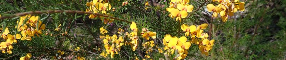
Lovely display of waratahs (photo: John G)

We took a detour from the fire trail to check out a note on the map “axe sharpening groves”, and sure enough, there they were, in fact John and I had been down this creek before, and hadn’t noticed these groves, but then again it was after rain and we would have missed them.

Further down the creek above the first of two waterfalls. We didn’t go any further, we’d already been down the creek before, so returned to our packs.

Another note on Ray’s map, a rock “bridge”, we’d walked past this before but hadn’t notice it. This rock “bridge” was the first of about 3 or 4 that we came across in the next creek (rock bridge is when the water flows under the rock).

We’re in our creek now and it’s not looking all that interesting. Sand banks and not many rocks around – although I should have looked above the banks to see if there were any “grassy meadows”, LOL.

About 500m further downstream, the terrain started to look more promising. We were approaching a point of interest on the map “Group 30” which would be followed by a “swimming hole”. It was bloody hot, we could all do with a swim!

We eventually reached the “swimming hole” can’t imagine actually swimming in it.

But, the rocks around the swimming hole were covered in sharpening grooves.

They were everywhere, I counted 162 of them, but there would have to be more as some were covered in sand.

Never, at any of the aboriginal sites that I’ve seen, have I come across so many. We figured that hard (harder than sandstone) rocks were brought to the site, sharpened for axe headsand then used for trading. It would appear that once the grooves reach a certain depth, they aren’t any use for sharpening anymore, so they would start at a new part of the rock.

We dropped our packs at the swimming hole and continued downstream to see if we could find anything else. Supposedly, Ray found 10 sites in a 2k section of the creek, would we find more than the sharpening grooves already found?

We came to another rock platform, but only one spot where there were 2 grooves.

Compared with the other site, this one wasn’t at all impressive.

There was a nice display though of a carnivorous plant, the stems have red sticky “fur” on them, which captures ants and flies which then decompose and provide the plants with nutrients.

We didn’t find anything more in the 2k area that we searched. Given that the maps were drawn over 60 years ago, anything that was there would have by now been covered by vegetation. So, back at our swimming hole for lunch.

By 2.30pm everyone was flat out, it was really hot and we all decided to have a nap, was too hot in the sun to even put our tents up.

Once the sun went down, John found this engraving of an eel, and a little further over another engraving, but too faint to make out. (Photo: John G)
We had a nice campfire away from the sharpening grooves, most of us had brought along things to share, popcorn (cooked over the open fire), chocolate muffins, baked apples, soy crisps – we were stuffed by the time we all went to bed.

Next morning, we set off after breakfast to explore a ridge which apparently has a site on it. Both John and I had looked up the Aboriginal Heritage website and searched for Aboriginal site in the area we’d be in, and there was a site shown up on this ridge. Nice walking in the cool of the morning, and the wildflower displays were spectacular.

Up on the ridge it was very easy walking.

We came to some good rock platforms, about a couple of football fields long, but sadly no art sites.

We found a cave at the base of the cliff line, we joked that if Garry S had been with us he would have wanted to tag it!

Then we found another cave. We think this might be the “Aboriginal site” that is listed on the heritage site. The floor could have been flattened to use as a shelter for a small family and up on a ledge inside the cave, we found a rock that definitely didn’t belong there, and I can’t imagine anyone who lived in the area putting it there so, it was probably one of the First Nations people.

We continued out along the ridge to admire the view, I have to say I was nervous about John and Jim on the ledge they were on, totally overhung.

Great view.

Time to return to camp, once again, the walking was very easy (no re-growth vegetation).

On the way back, we came to another point of interest, a cairn with rocks extending each side of it. We agreed that it was an old “property boundary” marker when the area had been surveyed many years ago.

Lovely display of waratahs, the bush had to be 5m high.
Close up of a waratah, thanks John, I wasn’t tall enough to take a photo of this as we passed by (Photo: John Gray).
We were back at the campsite by 9am, finished packing up and then headed cross country to our fire trail. Back at the cars early enough to rendezvous at The Hub for coffee and lemon/lime tarts.
Thanks everyone for coming on this walk with me, whilst we didn’t find all the art we were looking for, what we did find exceeded our expectations! There’ll definitely be more walks in this area!
The Story of Ray …
I met Ray Meisterhans in the mid-90s, I had joined CMW (Coast & Mountain Walkers) and needed to do my third “qualifying” overnight walk before my three months’ temporary membership ran out (they aren’t so strict these days). I saw Ray’s walk into the Jamison Valley on the CMW calendar and meet him on Katoomba Station at the prescribed time (he went everywhere by public transport; don’t think he had a car).
Anyway, it was raining at Katoomba, bucketing down in fact. I sat on the station waiting for the train. The only person that got off was this really old wizened looking man, with a backpack that looked like it had been patched up for the last 50 years. The only person getting off the train that looked like a bushwalker, must be him!
Upon finding that it would just be the two of us, I asked him what he would have done if I hadn’t turned up … “probably just done a day walk” says Ray. I said I needed to do a qualifying walk (hoping that he’d say “that will do as your qualifying walk”) but he said that we’d have to do the overnight walk – I couldn’t get qualified with only a day walk. So, we set off … in the rain.
At the time he must have been in his mid 70s, but he looked way older than that – but then, having just turned 50, everyone in their 60s and 70s looked REALLY old to me. We walked down to the Jamison Valley in the rain along the Ruined Castle track. At lunch time, we found a small overhang where we decided we’d shelter and spend the night (out of the rain).
He was a man of few words, I’m sure over the next 8 hours, I did most of the talking and he probably said less than 50 words. However, he did bring out a map that he’d drawn. It was only 30cm high but when he rolled it out it was about 1m wide, and it showed (in detail) the ruins of the aerial ropeway (aka Flying Fox) which was built in 1885 from the Ruined Castle to the terminus of what is now called the Scenic Railway. The flying fox was used to transport coal out of the mine, it collapsed after only six months of operation and the infrastructure (cables, buckets for the coal etc), was strewn across the valley. Ray had marked the locations of all the infrastructure on the map, it was an amazing feat, he must have walked every inch of that valley to find the buckets under the vegetation.
I didn’t go on any more walks with him. I rarely remember a trip as vividly as I remember this one, and I usually struggle to recall characters/people most of the time. But, this quiet, shy man obviously made a huge impression on me.
So, the background of Ray and how he came to draw those amazing maps … Ray was one of 10 children and spent his early life in the Dubbo Gully area (Mangrove Creek). He and his siblings picked wildflowers to take them to the Sydney Markets. Unsurprisingly, with his shyness, he never married. Apparently, his parents moved down to Ryde at some point and Ray and some of his brothers worked the property in Dubbo Gully (growing flowers that were sold in Sydney). From 1959 onwards, together with a friend, Ray the area looking for caves and Aboriginal carvings. Ray documented and made drawing of carvings they found in the sandstone rocks. In addition to the Dharug maps, Ray also produced many detailed ‘free hand’ maps of areas such as the Blue Mountains and Mangrove Mountain, which showed old convict works and settlements as well as aboriginal carvings. For a man who had limited education, these maps were masterful in their accuracy and detail. This valuable collection was gifted by Ray to the Wisemans Ferry Historical Society. In the 1960s, Ray moved with his parents to Ryde where he lived for the remainder of his life. He passed away peacefully on 26 June, 2021, aged 93 years.
A neighbour who knew Ray and his brother John in the 1960s and 70s noted that “they often went off exploring the rock surfaces at night, illuminating them with a carbide lamp to see if they bore any engravings … they were both taciturn types, who might take several minutes to consider a question, before venturing to answer.” That’s the Ray I encountered (lol).