 SOUTH COAST, NSW – 21 – 24 May 2023
None of us had bothered to look at the weather forecast beyond our Murramarang walk. Basically, we hit the bottle shop at Batemans Bay, with Cathy notably asking “do you think four bottles will be enough?” And then we drove non-stop further down the coast to Eden (roughly 400k), on our way to the Light to Light walk.
We were heading for the accommodation that Trish had arranged at the Telegraph Bunkhouse at the Green Cape Lightstation. The further south we went, the more the wind picked up! By the time we arrived at the Telegraph Bunkhouse, the winds were gusting at 70k/hour and it was a mad dash from the cars to get our gear inside.

The Telegraph Bunkhouse – 2 rooms, a bathroom and sleeping 4 people, it was tight! But the wind was roaring, after getting our gear inside we rugged up, it was freezing (so thankful I brought the North Face puffy jacket)! Luckily there was a good gas fireplace, plus a small kitchen.

Taking advantage of the remaining daylight hours, rugged up, we all went out to the end of the walking track.

Looking back at the historic lighthouse plus the new steel one next to it which is automated and powered by solar panels. The manned light station operated from 1883 to 1992.

On the hill on the far left you can see the lighthouse keepers cottage, there were apparently three full time lighthouse keepers (and their families) 24/7 to man the lighthouse, all night, every night in four hour shifts.
Behind the cottages, there is also a stable, horses were used for the heavy work of bringing supplies from Bittangabee Bay to the light house. Bittangabee Bay was a sheltered inlet where ships could anchor to off load supplies. Later in the walk we’d see the storehouse at the bay.

The seas had picked up by now and the sea spray was wafting over us.

Group picture, we didn’t hang around long, it was freezing cold.

Interesting architecture.
If there is one place you want to be with gale force winds it’s in one of these buildings, the walls were 20cm thick and very cozy inside. After dinner we sat around and planned the next 2 days. The intention was to do the full walk – all 30k of it over 2 days, but with Peter’s legs still giving him grief, we decided that we’d do some day walks on the track, walk out for x kilometres, see what there was on offer and then turn back. Once we’d made a plan, we each had our first hot shower for 2 days and then had a great night’s sleep on comfy beds.
Next morning, once the winds had died down, we took the opportunity to take a better look around. With three lighthouse keepers, the head lightkeeper had a separate cottage and the two assistant keepers had a duplex cottage each a short distance away (sharing bathrooms and a kitchen but each with their own bedrooms and living rooms). There were fences dividing each dwelling so that they had separate yards (I’m guessing in an effort to give each family some “distance” from each other).
We packed up and relocated our cars at the start of the formal walking track.

The first stop on the days’ walk was a mere 300m away at the Ly-ee-Moon Cemetry. On 30th May 1886, the Ly-ee-Moon sank on Green Cape with the loss of over 70 lives, all of whom were buried here in this Cemetry. Sadly only a few of them were identified, Many of those who lost their lives were children, and whilst there are white rocks indicating grave sites, there certainly aren’t 70 rocks. Thankfully, there is a wire fence surrounding the Cemetry so people don’t walk on the graves.

After reflecting at the Cemetery, we were on our way with the destination of Pulpit Rock – said to be a mere 3k away. Initially we were walking along the track through a lovely melaleuca forest.

Then we came to a firetrail intersecting the track, so we followed it down to the coast, and came to a fisherman’s track which lead down to the rocks. Very rugged coastline.

Trish rockhopping down to a nice platform that we could explore.

I was hoping that this inlet would lead to a sea cave, but it ‘dead-ended’.

However, there was a “blow-hole”, which is perhaps a sea cave, you wouldn’t be able to check out though until low-tide. Or, on a sunny warm day you could brave the sea spray and get closer to take a look.

Whilst I was checking out the blow hole, Trish and Peter were checking out “something” in the water.

Turns out these were seals in the water, they must have been laying on their backs with their flippers out of the water, and according to a NPWS Ranger, this is what they do when they are trying to regulate their temperatures.

After we’d had our fill of seal watching (and looking for whales), we were back on the track to Pulpit Rocks now walking through low heath. We’d been walking for quite some time, all of us were thinking that this was the longest 3k that we’d ever walked.

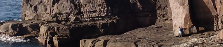
And finally (after what seemed like a 5k walk) we were at Pulpit Rock, the big rock in the centre of the image must be Pulpit Rock. I’m barely visible walking over the rocks.

From the Pulpit Rock lookout, when you looked north there was this amazing slab of red rock, I’m guessing that local adrenaline junkies jumped off the rocks in the bottom rh corner into a deep pool below, and then climbed out on the red rock.

Back on the track, returning to Green Cape and Trish activated her watch to log the distance back to exactly how far it was – and yes, it was the advertised 3.5k!

Good showing of Grevillea along the track.

And this unusual wildflower, not sure what it was, but very pretty, although not much of it around.
Back in the cars and on our way to Bittangabee Bay to check out that campsite, we wouldn’t be staying here, but we wanted to see what it was like for a future trip.

The lovely sheltered cove of Bittangabee Bay, you can just see the storage bunker.

We walked out to the headland had a leisurely lunch, constantly on the lookout for the elusive whales – we’d been spoiled on the first walk. The campsite at Bittangabee is currently under refurbishment, and it’s looking stunning with good walking tracks recently installed.

Trish and Peter took the track back and would follow the signs to the historic storage bunker, Cathy and I decided to have an off track adventure, following the rock platform around into the bay and then finding out way up through some scrub.

The Storage Bunker – from 1880 to 1927 supplies for Green Cape Lightstation were off loaded in Bittangabee Bay and stored here in this bunker until collected. A horse-drawn tramway was constructed to take supplies from here to the Lightstation, you can still see remnants of the infrastructure on the shoreline. The tramway was 7k long and cut through dense vegetation and up/down creeks.

Back to the cars and we’re heading for Saltwater Creek Campsite (where we’d spend the night). We had a quick tourist stop though to view Disaster Bay and further down the coast to Nadgee National Park. There is a CoastSnap Station here, where people can place their phones in a holder and take an image of the beach, then post it on social media with the hashtag “#CoastSnapDisasterBay”. I’d never heard of this before but it’s a global initiative to monitor the changes in coastlines.
We arrived at Saltwater Creek campsite around 3pm and set up camp. It’s not as up-market as Battangabee campsite but we had a nice grassy site where we could set up both tents, plus our own campfire pit (all we needed was wood).

We decided to have a “cuppa” before we did anything else and then Trish brought out a birthday cake for me … yes, it was my birthday, all of 73 years! Trish had brought the cake back in Bateman’s Bay when she found out that my birthday was coming up. Thanks so much Trish for your thoughfulness!

We had a few hours of daylight left, so we took a quick walk south on the track to see what we would have seen if we’d walked the whole way. Good coastal view, nice red rock platforms to see, plus, we could see how much the fires back in 2019 had decimated the coast.

I had a lot of fun disturbing these Hooded Plovers, they’d settle in a spot on the sand and then I’d run at them and they’d take flight, then they’d land again, not sure who was having more fun them or me.

On the way back we spotted this lovely black swamp wallaby grazing.

Camp set up and the fire ready for happy hour.
We enjoyed more wine and then a spirited discussion on what I believe is a game-changer in overnight walking … Macaroni and Cheese! Add spaghetti bolognaise sauce to it and it’s delicious.
We’d noticed that there were lots of little holes dug in the ground, we couldn’t figure out what they were until the Ranger told us they were evidence of Bandicoots who root around in the ground for a particular truffle-like fungus. For more information on Bandicoots go to this website, they’re fascinating – best interesting fact – 12 days gestation!

Turns out Bandicoots like a bit of Macaroni & Cheese – yes, I know they shouldn’t eat it but there was only a little in the billy and they were so cute.

Peter T’s better shot showing it’s cute little face.
We were up bright and early to a VERY COLD frosty morning. The tents were soaked both inside and out, so we left them and headed off on our next adventure – to check out the Mowbray Point campsite, about 5k north of Saltwater Creek.

Initially walking through a very pleasant melaleuca forest, we found this stunning grouping of fungus along the way.

Once out of the forest, it was mainly heath walking. We popped out onto the coastline onto a nice rock platform.

This looked like a good sea cave, you’d have to abseil into it at a full low tide, but it looked as though it was worth the effort.

An interesting inlet, I walked to the end looking for a sea cave but it was a dead-end.

Great rock platforms, I believe Mowairy Point was another k of walking beyond the first headland. I didn’t feel like walking any further so I sat on these rocks enjoying the sunshine. Apparently the Mowairy Point campsite was a lovely grassy meadow.

I watched this fishing boat for quite a while, wondering what the “banging” was that I was hearing. Anyway, turns out this was one of 3 abaloney fishing boats (with divers getting the abalone as it was such a calm sea to go diving off the shore-line. The banging was the person on board getting the abalone out of the shell.

The return walk … really sad to be finishing our exploration of this national park, very scenic.
We got back to camp, packed up and headed our separate ways, it was mid-afternoon and neither of us was sure where we’d stop on the way home, and after 6 days of organising us, I’m sure it was a relief for Trish just to negotiate with Peter where to go next (lol).
Cathy and I decided that we’d find our way back onto the Princes Highway and then figure it out. We drove onto Eden, just to see what the place was like and had a quick late lunch and decided that we’d head as far as Huskisson and stay the night there and then the next day do the 1/2 day walk out onto the Beecroft Peninsula to Gosangs Tunnel that I’d been to before and though Cathy might be interested. So off we went!
We “lucked” upon a great motel in Huskisson, arriving just on dusk and had our first really good shower in a week! We went out looking for dinner and found a good pizza place (thanks to the guy who let me sample his pizza), and then headed back to our room to open the last of the four bottles of wine that we’d bought in Batemans Bay … yes Cathy, four bottles were enough! Great night’s sleep on a wonderful comfy bed!

About an hour’s drive to the start of the walk – creek that you have to cross.

We were 10 minutes into the walk when we discovered that there’d been a lot of rain in the last few weeks, we spent most of our time dodging water across the track. Still it was an enjoyable walk.

Neither Cathy nor I had noticed a sign at the start of the walk indicating that the Tunnel was closed. But once there it was obvious, although this photo (from a NSW Crown Lands website), doesn’t show the barrier which, obviously is being ignored, the mesh was on the ground where people had walked over it. We decided not to go through the tunnel (child of the 50s and rule follower that I am), so instead explored around the front of the rockface.

Great view down into Mermaids Inlet (also closed off – due to “ongoing wet weather and a visual assessment relating to overhanging rocks and cracks in fault lines”. Nice view though.

The tunnel is around to the north – not where Cathy’s pointing – she’s concerned about yet another rock fisherman without a life jacket on!

We had morning tea and enjoyed the view (and looked for whales – “nothing to see there”) and then retraced our steps.
From here we went to the Minnamurra Falls walk (just outside of Nowra), neither of us had been there before and I wanted to know why so many abseilers broke the rule about abseiling the Falls. It was a good work out – 2.1k all up hill to the falls and then 2.1k downhill, took us about 2 hours. The falls were pretty good but the gorge below would be the main attraction. Though, for the life of me, I can’t imagine how those that have boasted about abseiling the falls in the past have managed to do it without being photographed by tourists, and walking past the rangers with a shit-load of ropes and gear!
We were back home by 4.30pm – always nice to get home.
So, would I go back and do the full Light to Light walk (Green Cape Lighthouse to Boyds Tower), it’s 29.9k? Probably, though I’d like to do it in 3 sections rather than the 2 we’d planned, it could be done in 3 easy sections, Green Cape to Bittangabee (8k), then on to Saltwater Creek (9.5k), then on to Boyds Tower (12.4k). This would allow plenty of time between each campsite to enjoy the scenery – which is truly stunning! Bugger – another walk on the wish list!
Big thanks to Trish for organising this add-on to the Murramarang Walk – definitely worth it. Thanks also to Peter and Cathy for their company on the walk and particularly to Cathy, such a good travelling companion. We managed 1,200k of driving, only getting “off track” once, and nothing phased Cathy, so agreeable and willing to go with the flow! Definitely hope to do something with you again Cathy!
Hey Marilyn!
Belated happy birthday wishes !!!! That chocolate cake was a nice touch!
Beautiful scenery and phot0s. Thanks for sharing!!!
Very nice touch. And thanks for the Birthday wishes.