 CARNARVON GORGE, QLD – 6 August 2022
A trip to Carnarvon Gorge wouldn’t ordinarily be blog-worthy, it’s a tourist destination that Jim and I decided to visit on the way home. However, the fact that I walked the whole gorge from beginning to 1k from the end AND back again is what is blog-worthy. All up a bounce trip of 23k including all the side trips, 46,800 steps! I usually “don’t get out of bed for a day walk” and certainly wouldn’t punish my body with a 20+k walk!
We drove from Mt Etna on Friday morning, taking a couple of stops along the way seeing some of the sights.

We trusted Karen again (Jim’s GPS) and managed to get on yet another dirt track. For a couple of hours there was nothing but bush, with a couple of signs pointing off into the distance, which I assumed were aboriginal settlements.

We were pretty happy when we finally got to a tarred road.
It was close to 5pm when we arrived at the campsite Jim had booked us into, it was pretty good and just outside the national park boundary. We spoke to one of our neighbours and he said he’d just finished the walk and it had taken him 8 hours and he’d done something like 25k. I didn’t like the sound of that, seemed a long way for me to walk in one day.
Clive had told us that it’s best to do all the side-trips on the way to the end, that way you saw all the good stuff because if you did the long part first you’d be too stuffed to do the side trips. Next morning, we decided not to take Clive’s advice and headed straight up the track to the end of the walk, as there was a nice canyon that was worthwhile seeing, it seems that somewhere during the evening and when we started the walk, 20k didn’t sound all that bad to me!

The track is really good, this is a section through a lot of palm trees, about halfway, I sat on a chair and waited while Jim went up and visited Ward’s Canyon, he came back and said it was worthwhile, so I decided if I felt up to it, I’d visit it on the way back.

Prior to this the cliff walls were quite a long distance away but by the time we hit Wards Canyon, the Gorge had closed in a little.

I really liked the vegetation, lots of palms and nice grassy areas, I could just see aboriginals camping here in days gone by.

There are quite a few side creeks, some of them looked difficult to explore, Clive told us that in the “old days” before it became popular with tourists the locals explored all over the place.

We’d passed all the turnoffs to the side-trips, and were now on the part of the track that most tourists don’t walk. When the track went across a pebbly part of the river/creek. We missed the marker which told us where to get back on the track and continued upstream in the middle of the creek, sure looked like a track to us. And, I convinced myself that it wasn’t well trodden because most tourists stopped at the Art Gallery side trip and turned around at that time. Well, it wasn’t, THE track and we were definitely in untracked country, and after about 500m of blundering about in the bush, we headed up the bank in an effort to find the “right track. It was nasty snaky bush and I wasn’t at all happy with going through it but I wasn’t going to turn back. After about 50m of this snaky vegetation we came out on THE track – so well-trodden still can’t believe that we missed the marker!

At one point the track went down close to the river.

We’re making really good time, apart from the minor off track adventure! We’re now at Cathedral Cave and this was incredible, virtually every part of the cliff face (up to about 3m) was covered in aboriginal art. We’re in Bidjara and Karingbal country and we’re so fortunate to be able to see this artwork. The images were created during gatherings of the Bidjara and Karingbal people when they met to carry out important ceremonies.

These net paintings indicate that some of the ancestors were laid to rest here. In their culture when a person passes away their spirit must be returned back to country. Complex rituals prepared a person for burial, in certain situations an elaborately made burial cylindar would be crafted from the back of a tree, important items would be placed inside and once the cylinder was secured it would be placed within caves and tunnels that occur in the sandstone walls.
According to interpretive signate, “Dr John Beaton carried out archaeological excavations in the floor deposits of Cathedral Cave in 1975. Carbon dating of excavated campfire charcoal tells us that people have been visiting this place for approximately 3,560 years. Excavations also revealed engravings similar to those still visible today. They extended 90cm below the present floor level”. That’s pretty amazing.

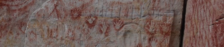
Warriors and hunters would often stencil weapons to draw power from the site so that during hunting trips or battles those weapons would hit with greater force and accuracy, in the middle of this image are two weapons.

Hand stencils (left of image) represent a person’s connection with the site. It’s said that the left hand means giving spirit back to the land whilst the right symbolizes gaining strength from it. I think the lines are boomerang stencils but I’m not sure how they could have held so many in place at the one time to stencil them.

This part of the cliff wall had a lot of grooving in it, not sure what it depicted, there also seemed to be a lot of sharpening grooves.
We only had a few hundred metres or so to go before we got to Boowinda Gorge. We’d been told that it was worth the visit, more like a canyon than a gorge – and anything that sounded like a canyon I just had to see.

We’d been told that it was really hard walking, but compared to other canyons we’ve done, this was a breeze, almost the whole canyon had a flat pebbly base, with very little elevation. Love the wave walls.

Some side creeks coming in, if we had more time they’d be worth while exploring.

This was our turn-around spot, the cliff walls had disappeared and apparently you could walk quite a way further and eventually get to a track which would take you to a break in another escarpment and then to Battleship Spru and beyond.

I loved the canyon sections and took more photos on the way back.

More lovely mossy walls.

Who wouldn’t love these canyon sections! Boowinda Gorge definitely delivered, one of the highlights of the walk.
Once out of the Gorge, I sat down and Jim went for another k upstream to Big Bend (a campsite). I was saving myself. Apparently, you can walk to Big Bend, camp and then go up Boowinda Gorge as part of the Carnarvon Great Walk, 6 – 7 days, an 87k round trip through the Sandstone Wilderness. This is definitely on my to-do list for the future! If the track on the rest of the walk is as good as it was for this 10k section, it would be dead easy.

Once Jim returned (Big Bend campsite ok but quite a few people there), we were on the home stretch, and it was time to do the side trips. Walking back I took note of all the palms, this one is like one I had at my old house but minus the deadly thorns on the branches.

A good shot giving you an indication of the sandstone walls (with palms below), the sandstone is a lot harder I think than the Blue Mountains sandstone that we’re used to, doesn’t weather as much (I think).

As you can see, the track is really good, it would have to be with the hundreds of tourists each day that do the walk. Because we’d opted to do the full walk, we didn’t see many people once we’d passed the halfway point.

Before long, we were at the Art Gallery turnoff. I have to say it was a good idea that we bypassed all the side trips on the way up, if we’d done them first, I’m not sure I would have bothered going all the way to the end. There were a lot of steps up to the Art Gallery, but it was well worth it.

Grooves in the sandstone. The signage said this was a woman’s site, but if so, what were the sharpening groves doing there?

Lots of boomerang and hand stencils.

The site was really extensive, probably 50 – 70m of gallery, very impressive. Someone that we spoke to said that he thought that some of the stencils were “new”. It did look like they were (they didn’t show much sign of weathering), and it stands to reason with the aboriginal communities so close to the gorge, that they are visiting the gorge still to either conduct ceremonies, or initiate younger members of the community, at least I like to think that they still have a connection to country and are continuing their traditions.

These groovings are what signified (according to signate) that this was a woman’s place, a place for birthing – there was water close by which is usual with a birthing place. These groovings are supposed to represent a woman’s vulva, there were hundreds of these groovings.
Retracing our steps we were back on the track and heading for Wards Canyon.

There were quite a few steps and by this time I was questioning my ability to continue with all these bloody side trips! But once at the top it was worth the effort.

A stone path had been formed in the canyon to stop people from going “off track”.

Lovely coloration in the pebbles in the canyon.

And what makes this canyon special. You can only walk to this spot, there’s a barrier so you can’t go beyond it. Under the canopy of the canyon is one of the largest ferns the King Fern. As Australia’s climate became drier and hotter, the rainforest along with the king ferns retreated to coastal fringes. Right now, were right in the middle of Queensland, in the dessert, the fern really has no business being here! And, here is the only place in Central Queensland where the fern survives. Fronds of the fern have no woody tissue, – water is the only means of support. Water fills the fronds, exerting pressure outwards and keeping them rigid, like the water in a fire hose. At up to 5 metres in length, the fronds of the fern are among the largest of any of the world’s ferns.
Back on the track and then we get to the turnoff for another side trip, roughly 1k round trip to the Amphitheatre. More steps and a climb to get there and then a ladders up into the cliff. We stopped to talk to some people and asked whether or not the Ampitheatre was “worth the visit”. They gave it a 10 out of 10, so we turned our sore feet towards the track.

I have to say I was excited to see the ladders – a bit of adventure – so far it had been a “soft” adventure! Maybe my feet weren’t as sore as I thought.

A cool tunnel to walk through.

Jim at the back of the viewing area. Wasn’t actually supposed to go up there but the signage was a bit obscure.

In the Amphitheatre, massive walls, the tunnel and the Amphitheatre itself were formed by erosion.

Looking back from the tunnel. There is a barrier to prevent you going further to explore, I imagine Clive and his friends would have been able to have a good look around, and see if it went further.

Going back through the tunnel to the ladders.

There was an art to getting down these steep ladders, walk backwards. One wonders how the early explorers found the Amphitheatre, wouldn’t have been easy climbing up without the ladders!
Back on the track and we’re approaching the final side trip, the Moss Garden, I’ve pretty much had enough now, and I’ve seen enough mossy rocks in my life, did I really need to go. Yep those same people we’d spoken to before we went to the Amphitheatre came along and gave it another 10 out of 10, so off we went.

Yes, it was a 10 out of 10, and the 1k track ended at a small waterfall, Clive said that in the old days you could go further up the creek but it’s now prohibited, apparently there’s aboriginal art further upstream, not sure how the aboriginals got up the waterfall.

And the moss was spectacular. The sandstone above the moss soaks up rainwater and over thousands of years this water seeps down through the stone, eventually the water meets a layer of rock known as shale and it’s impenetrable. With nowhere else to go, the water moves sideways, trickling out from the wall, and this constant supply of moisture sustains an oasis of mosses, ferns and liverworts. Still hard to imagine that we’re in the middle of the dessert here!

There was moss galore, I’ve seen a lot of moss in my day, but this was definitely better and was worth the trek to get to see it!
From the Moss Garden it was 6k back to the start of the walk. By now we’re well and truly tired, but I have to admit to a feeling of satisfaction when we got back to the car. I’d done it, 23k – mind you I just had a day pack, but still quite an achievement.
We packed up next morning and made a beeline for Moree, our stop for the night. We spent all of the next day and the day after travelling through flat country, with fields as far as the eye could see, ready for cotton, wheat and canola to be planted. We were travelling through the Murray/Darling basin, the start of these rivers. There were many, many dams and canals all full of water, one wonders what the rivers are like downstream, can’t be good for the ecology of the rivers! Why aren’t they planting hemp instead of cotton?

Great storm clouds on our way south.
And so ends our Queensland Road Trip, thanks so much Jim for chauffeuring Ms Daisy most of the way. It was a great trip, definitely more to see on the next trip!
This looks amazing!!! Thanks for sharing! I am totally impressed that you walked that
Much in a day!!! I am in the midst of binge-watching several of your trips!
Truly fantastic. Thank you!!!
Yes, it was amazing, love it when you binge-watch the blog!