 CENTRAL COAST – MT ETNA – 20 – 24 July 2022
I guess after my great road trip from Alice Springs to Kununurra it was too much to ask for a trip where everything went according to plan. Not that anything disastrous happened, just a lot of unexpected adventures. It didn’t help that we did almost the entire trip during yet another “rain event”.
Jim C and I were going to meet up with some MSS cavers at Mt Etna and when Jim said he’d be happy to have someone drive up with him I jumped at the opportunity, I haven’t been up to Queensland in quite a while.
Jim picked me up at 12.30pm and we were on the M1 north, nothing much to see for the first half of the day – not a lot of rain but it was overcast. Our destination for the night was Taylors Arm, I didn’t have a clue where it was. My son, David, knew though, apparently there is a pub there called The Pub with No Beer based on a poem written by a Queenslander back in the 1940s – and immortalized in a song by the legendary Slim Dusty (who grew up nearby just outside of Kempsey). More about the pub later!
On the way to Taylors Arm, we decided to call in to see Ellenborough Falls, with the rain we’d been having the view of the 200m Falls would be spectacular. We turned off the M1 where the car’s GPS (Karen) told us to go. Jim’s GPS is a bit out of date, so some of the directions Karen told us to go were a bit iffy, nevertheless, we were (probably) on the right road.

We were making our way up through lovely hilly country, then we got on a dirt road, this wasn’t unexpected. The scenery was spectacular.

Driving higher and higher onto the range, we then came to a Road Closed sign, not unexpected I guess, the rain had been torrential and I’m sure there were land slips all over the place.
Undeterred Jim set the GPS for Taylors Arm, and after backtracking for quite a ways, we headed off in a new direction. By now it was around 4pm, and we were looking forward to a beer at The Pub With No Beer.
Eventually Karen told us turn off the tarred road, onto a dirt fire trail, again not unexpected in this neck of the woods. We ambled along the dirt fire trail which was in pretty good condition. The road got narrower, and narrower, and there were hardly any houses to be seen, or lights for that matter, it was getting dark.
Then we came to a Y intersection – one way to a farm and the other way along a decidedly narrow, rutted dirt track, but Karen indicated that Taylors Arm Road was just 100m away. Around about now I’m starting to think we’re in Deliverance Country!
Gingerly we drove down the hill, trying to avoid the ruts. 30m from where Karen indicated Taylors Arm Road was, we stopped. Ahead was a very soggy, muddy, patch. Jim got out to take a look, with his flash light, by now it’s just on dark.
It was definitely a no-go and if Taylors Arm Road was there it was a muddy track, not an option in Jim’s Suzuki S-Cross. With no-where to turn around, Jim backed up the road, with me walking in front of him with a torch to highlight the best way. I found a spot where I though he could do a 16-point turn around and he started the manoeuvre.
That’s when everything turned to shit. He was stuck, the track was very narrow and one of his wheels was caught in a bit of a rut. The next 40 minutes saw us alternately reversing, trying to put sticks under the wheels, me pushing, Jim pushing, both of us pushing, all to no avail. By now I’m thinking I’m going to have to go back to the farm gate and see if there’s anyone at the end of the road who could help us (I wasn’t overly confident, there was no house light in sight and what about vicious farm dogs?). And, I fully expected there to be dueling banjos if there was anyone at home.
“OK, let’s give it another go” says Jim, I’m behind the wheel and with amazing strength, Jim managed to push the car up over the rut, and I’m off up the hill, only stopping where it was flat and relatively dry.

After regrouping, and deciding there was no way we were following Karen’s directions on that GPS, we retraced our route and made it back onto tarred road, and then fired up my phone’s mapping and put in Taylors Arm (not Taylors Arm Road!).
Off we went, eventually getting to tarred road – so long as were we on tarred road I was happy, and then there was a green and white sign for Taylors Arm – hooray! My jubilation was short lived though, next thing we knew we were on dirt road again, “not happy Jan”.
Deciding to trust Google Maps (on my phone), we continued on the dirt road, it was a great relief to eventually come across street lights – and they were lit – an area with electricity! Shortly thereafter, we were on tarred road again and then we were on Taylors Arm Road – I checked WhereIs when I got home and for the life of me I don’t know where we went – it’s still a mystery!
Taylors Arm is an interesting place, there’s an old boarding house which was built around 1890 (that’s where we stayed the night). Then there’s the pub, built in 1895. The Pub With No Beer got its name from the poem The Pub without Beer. Apparently author Dan Sheahan who lived in North Queensland went into the local pub during the war and the owner told him that the American Troops stationed nearby during the war had drunk the entire month’s allocation of beer (beer was being rationed during WW2). Sheahan rode home (sober) and wrote the poem, then in the 1950s a country music singer, Gordon Parsons is believed to have written the song based on the poem, and then Slim Dusty recorded it and made it famous.

Inside the pub, lots of memorabilia, I was just happy to sit down, eat some pizza and have a well earned a glass of wine!

The bar, plenty of beer on tap!
The guest house was pretty basic, I’m guessing that backpackers usually stay there. At $40pp for the night it was just right and the showers were nice and hot – amazingly I had hardly any mud on me from the bogged car.
Next morning we headed off to Kyogle and the Natural Bridge which is up on the Queensland border. Why Kyogle? When I was on the train going up to Mackay back in 1970, the train had passed through Kyogle and I loved the place, lovely rolling treed hills, cattle grazing on green grass, and lovely old buildings. I always thought I’d like to live there so thought a drive through would be good to see what it really looked like, 50 years later. So, off we headed.
When we eventually got to Kyogle, it wasn’t as I remembered it, so that’s good I can cross that off my “maybe I should” list. So, off now to the Natural Bridge.

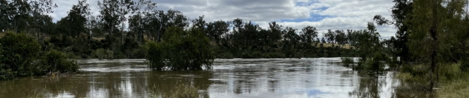
First we were driving along a river, and it was obvious that there’d been a lot of rain around (well we knew that, we’d been driving through it), and it was obvious that there was a lot of run off from the landslips as the river water was very muddy.
We were heading off into the hills and it was now raining cats and little dogs. Someone had suggested that we be careful of land slips – that was good advice. The road was also riddled with pot holes. I have to say that I haven’t seen this many land slips ever before, and not only land slips but parts of the road had slipped away down gullys. These landslips were from the flood event that Qld/NSW had had back in February/March, the landslips were all cleaned up but with all this rain I wasn’t at all confident that there wouldn’t be more destruction. We soon crossed the NSW/Qld border and miraculously, the road was great, no more pot holes on the Qld side.
Eventually we came to the Natural Bridge turnoff, I was concerned that we wouldn’t get in to see the Natural Bridge because there was a “road partially blocked alert” on Google Maps, but it was only a small sapling down on the road. We got to the parking lot and the rain was bucketing down. Jim said he was going down to see it anyway, I decided it was too wet, so I stayed in the car. Then I rumbled around in my suitcase and found a rain coat so thought I’d go down to see the Natural Bridge, after all we’d come all this way.
So, I headed down the track and then came to a sign, turn left to enter, exit on the right. What to do? I had the car keys so if I went down the entry track, Jim could be coming up the exit track and be locked out of the car. Bad planning on my part, so I went back to the car. Jim came along after about 15 minutes and by now the rain had eased off so the two of us went back to see the Natural Bridge – well worth the visit.

The bridge itself, apparently this was caused by a lava tube.

Underneath the bridge and into a massive cave (which has a cave tag I believe).

The water flowing to the waterfall and down into the cave.
By now it’s close to 4pm and about time we found somewhere to stay the night, so we headed down the road in search of an old country pub (non existent between The Natural Bridge and Surfers Paradise). We eventually arrived at Nerang and with phone reception called up a few hotels, no room at the Inn! Then we found the Commercial Hotel and they had a room with two beds but it was $160 a night – WOW twice what we’d paid at The Pub With No Beer. We ummed and ahhed and then decided it was too late in the day (and raining cats and dogs still) for us to be blundering around looking for a cheaper option so we booked in.
Turned out to be one of the better decisions that we’d made so far. Lovely motel, brand new, and they offered us a free drink at the bar and 10% discount on meals + they had senior’s meals on the menu, so in actual fact $80 each wasn’t all that bad. Best night’s sleep that I’ve had in a while!
We headed out next morning and hit a Hungry Jacks for breakfast – wont be doing that again! So, back on the freeway and we’re heading for Childers where we would stay two nights in a 1800s pub, I’d been hoping for a night in an old pub.

The freeway was not too busy after 9am, but the rain was horrific, I’m pleased Jim was driving. So much for escaping the Central Coast’s freezing, cold wet weather!
We pushed through and eventually decided that we’d pull off the freeway around 11.30am for a coffee. We really didn’t know where we were going but it looked like they’d had a lot of rain.

Eventually we arrived at Palmwoods which is a bustling tourist hot spot. We had lunch in a restaurant across the road from this old garage that’s been converted into a “diner” pretty cool.
We then decided that as we were so close to Maleny and we knew an ex-MSS member there, we’d drive up to and “drop in” on Scott.

Well, the first road we drove down was “closed”, with water all over the road, and everywhere, so we decided that wasn’t a good idea so turned back.

The next road was closed too, eventually we found an alternate route back to the Freeway. On checking out where Maleny is on Whereis, it was probably a good idea that we didn’t continue as it was way out of our way. And probably not the best of ideas we’d had with all the flood waters, we could have been stranded!

Back on the freeway, we made a bee-line for Childers – the scenery wasn’t much to write home about, but at least the roads weren’t closed!
Jim was keen to see where his uncle had lived and worked as a barber in the small town of Childers. We arrived around 4pm, I have to say of all the 1800s pubs in town, the one we stayed at was the least attractive, ah well, we had a bed for the night so what the hell.
We dragged our gear up to the room – very small, a big come down from the night before! Anyway, we didn’t care, it was only $40 a night (each), you get what you pay for. We had a lovely dinner at the pub, lots of Merlot and met some people from Airley Beach, who happened to have lived a lot in SE Asia so it was fun reminiscing from my years spent there in the 1970s.
We called it a night, I read a book and was asleep before long, not Jim! There was a lot of noise from the pub downstairs, and then at midnight when the pub closed, there was much activity in the room next door, lots of squeaking bed springs and sound effects from the couple. I slept through the whole thing, but Jim was awake for most of the night!
Saturday was to be a “see the sights” day. My first stop was the visitor information center to pick up a brochure for the area. The center is on the ground floor of the Palace Hotel built in 1903.
Upstairs in the Hotel is a memorial for 15 backpackers who died on 23 June 2000 when a previously evicted resident of the (then) backpackers hostel set a fire in the downstairs common area. Of the 88 people who were living in the hostel at the time, 73 escaped, some jumping onto roofs of buildings next door. The building, the majority of which survived the fire, was then converted to the visitor center (downstairs) and a memorial, art gallery upstairs. The memorial, a 7.7m glass wall has light boxes for each of the victims with representative images selected by each family. It’s incredibly moving, particularly as the space taken by the memorial is where the backpackers would have been sleeping on the night of the fire.
After the visitor center, Jim and I paid a short visit to the Old Pharmacy, run by Council, the pharmacy is loaded with old wares that have been in the pharmacy since the 1890s when it first opened. We could have spent more time there, but we were on a mission.
Our next stop was the Flying High Bird Sanctuary, just outside of Childers. This is the largest free-flight aviary in Australia and houses 3000 birds. Jim’s father was a bird collector and had his own aviary and Jim is a keen bird watcher, so the Bird Sanctuary was a must see.

Most of the birds were exotic, but there were quite a few native birds there.

Lots of peacocks, sadly none of them would display their tails. There were a lot of albino peacocks too.

I really liked these ones, they were all over the place.

Jim with a friend.

Native black swans with the male (I think) sitting on some eggs, he was constantly rearranging the sticks on the nest.

One of two ostriches, I didn’t get too close, he was obviously giving me the evil eye.
The property is currently up for sale, it’s looking a little dated (it was opened in 2002), they employ quite a few staff, but my guess is that the owners are getting on in years and its too much for them.
Next stop, the Banksia Track in a nearby National Park, which apparently has over 60 different types of butterflies.

Soon after turning onto the road to the NP, there was a road closure sign, but we figured it that it hadn’t rained for a few days and the sign just hadn’t been taken away yet.

Then we got to this sign with lights flashing. We decided to continue on, just in case the road was now open.

We got to the first causeway and it looked ok , although after crossing we both agreed that “it was deeper” than we both thought. We soldiered on thinking “how bad can it be”.

It was really bad! The reason for the road closure sign, over 150m of river which was so deep you couldn’t even see the depth markers. Seems that there’s a large causeway here. We thought of looking for an alternate route but figured that even if we got to the NP, it would be soggy and possibly even flooded so we’d have to see the 60 species of butterflies another time (or maybe google them and see them on line – lol).
Road closures were becoming a “thing” for us, we were used to them by now! When we got to our next stop, the Boolboonda Tunnel, it looked like you could drive through it but with our history of getting bogged in Jim’s car and closed roads, we decided to do a walk through.

Taking just 12 months to build, the Tunnel opened in 1884, and was built to service the copper mining town of Mt Perry. At 192m it’s the longest unsupported Tunnel in Qld and the trip from Bundaberg to Mt Perry, took 4.5 hours! It closed in 1960 and apart from tourists checking it out, it’s the home to a colony of Large Bent Wing bats.
Our next stop was Bundaberg and the Bundaberg Rum Factory for a tour – we were both keen to take the tour but got there too late so headed over to the Bundaberg Ginger Beer factory, and did the self guided tour, checking out how to make ginger beer – looks pretty easy, or as we’ve just been told, you can buy a powder from beer brewing shops and just add water!
Loaded up with cheap Ginger Beer for the next 12 days, we then drove over to the coast.

We stopped at The Hummock, it’s a low lying volcanic remnant and the lookout is just 96m above sea level. You get a good view of the surrounding sugar cane fields. The Hummock holds an important place in local indigenous history. The Taribelang Aboriginal people were the first to inhabit this area. Their ‘burning mountain’ is the ‘Sloping Hummock” of today.
Having recently read a book about tsunamis, I looked out at the terrain, it’s a good thing we don’t have tsunamis in Australia, this area would be a gonner if one hit the coast.
We headed back to the Pub for our last night, thankfully this time with no-one in the room next door! Although the music did go until midnight.

After a 4 1/2 hour trip and 356k from Childers, we are finally approaching Mount Etna which you can see in the distance.
We’d been on the road for 4 1/2 days and travelled about 1,600k or 1,700k (it’s probably only a 1,350k trip but we’d taken a lot of detours!). There wasn’t much to see for the first few hundred ks and then there wasn’t much to see during the rain event, but it was a pretty relaxing way to get to Mt Etna, thanks Jim for doing most of the driving (lol). Great trip, so now, on to the next adventure, stay tuned.
Yep, I will never forget that lo..ooong car wash we went through between NSW border and Childers in QLD
Yep, was the longest car wash I’ve ever been in!
Also forgot to mention what is it with No. 7? All the rooms for accommodation on the trips up and down to Mt Etna were room 7, with the exception of the camp-site. What are the mathematical chances of that happening?
Yes, that was freaky with the #7 for all our accommodation.
My SES head says “don’t drive over a flooded rd”. Why? The road may be gone!
This is why we didn’t do a lap, cos the east coast needs 6 months to dry up
Yes, even coming through Moree on the way home, lots of water lying around.
Technically Australia does get tsunamis . There are a bunch of rocks down Wollongong way that got placed there by a massive tsunami some time in geological history.
Yes, up near Darwin and our islands off shore, they’re pretty close to the Indonesian rift, you just never know (lol).