 BLUE MOUNTAINS – 24 October 2021
As we couldn’t do the planned canyons (due to not being able to travel out of our region), Rod had planned Juggler as a replacement, which we did, but didn’t have a plan for Sunday. So, we sat around John’s kitchen table and tossed around some ideas for an “easy yet interesting” day and came up with a trip down Victoria Brook. John wasn’t coming but had done it recently so gave us an idea of what to look out for.
So, Rod, Jim, Omar and I set off with Kavita leading us for the day – sort of a training day for her. Our first “point of interest” was a dis-used coal mine tunnel.

The first blogworthy item was this grouping of sun-dews (carnivorous plants), haven’t seen such a lovely display for ages.

We were following a well worn track to our first point of interest.

Rod inspecting some cement bases for some old mining equipment long since hauled away.

The entry to the mine was actually signposted, you couldn’t miss it. So, we went down the tunnel with head torches. It was easy walking, I didn’t have to bend over, if you’d been tall you might have. There was evidence of what might have been rails to get the coal out. This tunnel went for about 200m (a further 100m is flooded) and dropped about 20m in elevation. The tunnel ended at the sump of water. The mine operated from 1920 to 1923. Interesting side trip.

Back on the track (sort of a track) and we’re looking for a way down into the side creek of Victoria Brook. We passed a small waterfall but it was very scrubby.

We had to walk about 50m downstream before we came to a safe way down, we had our abseil gear, we probably could have abseiled it but it was a bit scrubby!

In the side creek now, half a canyon.

The pool at the bottom of the small waterfall we skirted around. From the bottom we could see a good route out of the scrub that we could have abseiled down.

Back-tracked back to where we came down and we’re back on our route to the junction of our side creek and Victoria Brook. We came across a lot of waratahs in flower.

Another waterfall to walk around and we found a nice ramp down.

We dropped packs and walked back upstream to see what the waterfall was like.

It was a short walk through a pool and then two rocks you had to get through to see the waterfall. Kavita and Omar where you could get a good view, deep water beyond the rocks.

We’re now at the junction of our side creek and Victoria Brook and there was a big swim ahead of us so we scrambled up this rocky outcrop to avoid the swim – are we getting “soft”.

Getting back down into the creek was interesting, a bit of a slippery slope.

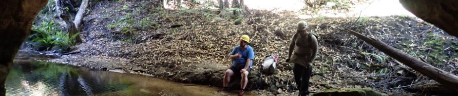
The creek was rather open for quite some time, with easy walking, then we came to this huge wave cave. We came upon footprints in the sand, John’s footprints from the week before.

The next point of interest – an “Arch” didn’t look like one as we walked in but the arch was then revealed.

Kavita walking out of the arch. The banner at the top of the post shows it off much better.
We had a rest and then assessed our exit options, we’d seen a lot of exit routes on our way to the arch, but picked a nice “rainforest gully” and set off.

Bit of a climb to get up to start.

Followed by a lovely rainforest gully. Easy-as walk out.
It was then a simple walk along the ridge until we came to the road down to Victoria Falls. A great day out, thanks Kavita for navigating for us (particularly the exit), and thanks to Rod for deciding on this little creek.