 BLUE MOUNTAINS NP – 27 December 2020 – 3 January 2021
It was supposed to be an epic 8 day trip! But, over the course of 5 days, there were endless reassessments and we went all the way from Plan A, to Plan I – reducing the trip to 5 days walking. Given the 7 day weather forecast when we started, this shouldn’t be a surprise to anyone!
On a couple of occasions (when I was re-assessing the risks), I did think that maybe I was being over cautious, but then on my return to civilization, I heard that there’d been an accident on the Saturday in the Wollangambe River (roughly in the area where we were walking) and two canyoners had died … “there but for the grace of God” I thought and determined that an abundance of caution was not a bad thing.
In hindsight, it was just dumb luck that I made the decisions that I made. If we’d all had packs weighing 10-15k, and if Louise hadn’t been checking the weather on a high point nearby, we would have proceeded as planned and would have been crossing the Wollangambe on the 3rd January, in (potentially) dangerous conditions – admittedly many ks downstream of where the accident happened, but still the possibility of a turgid swollen river!
So, back to the trip, we started in glorious weather, blue skies and 25+ temperatures. Louise was navigating for the whole trip and did an awesome job – I am always thankful when I can delegate the navigation! The objective for Anna and me (and Plan A) was to do South Yarramun and Interesting Creek, neither of which we’d done, Tim and Louise were going to do some other canyons along the way … and we were also going to check out 6k of Yarramun creek that none of us had done – which supposedly had good canyon sections.

We drove over to Wollangambe Fire Trail and started walking around 8.45am. Tim and Louise, each carrying a 40m rope (we would need that for when we did Up Ya Crack canyon – which didn’t happen – so Tim and Louise had weighed themselves down for nothing!)

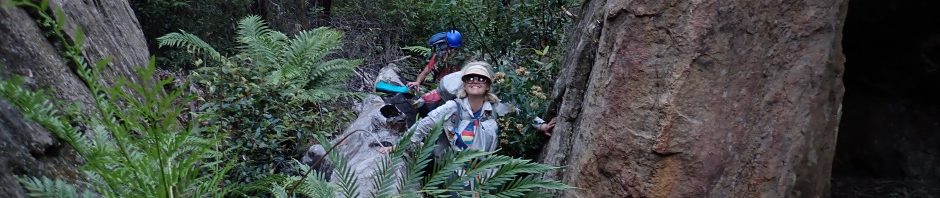
Anna coming up the first hill, her car is parked on the ridge on the horizon.

Almost to the top of our first hill, really easy walking after the fires – unless you’re Tim and carrying 80m of rope.

Walking down into South Yarramun … the only day that my hair looked half-way decent. (photo: Tim)

We’re now in South Yarramun Creek, a small canyon that none of us had done before. So far so good and it was nice to cool off in the water.

A small swim that we couldn’t avoid.

And then we came to a small waterfall, ending in a deep pool. There wasn’t a convenient anchor around, but Anna spotted a tree over on the right that we could use, and we’d avoid the swim at the bottom!

John G had said there was a 7m abseil in the creek. This might be a “bonus” abseil. Anna on the rope.

The small waterfall, you could probably downclimb this if there wasn’t this much water, but from above you couldn’t see where to put your feet. And it looked way higher when I was standing at the top.

Louise on the abseil.

The creek then became very, very scrubby with lots of downed trees to step/climb over, was really hard going with heavy packs.

So we made the decision to exit the creek (to avoid 2.5k of creek walking with a lot of swims at the end), and went cross country to the Sidewinder camp cave. By now it’s really, really hot and we were all suffering so we took many rest stops.

Finally arrived at the junction of Sidewinder and Yarramun, all that we needed to do now was scrub-bash to the camp cave (I’d said it was 50-70m but more like 100m).

Tim taking a well earned rest.

Once we’d unpacked our gear, Louise brought out frozen margaritas (which had melted in the heat) and we set up a massage train. Anna was very good at the massage thing! Had Louise squealing like a girl.

Anna even got her knee into the massage on Tim’s back – I was a bit afraid to let her massage me!
Louise made dinner for me on the first night, pasta carbonara – complete with bacon and fresh cream (delicious) no wonder her pack was so heavy.

Next morning Anna and I walked upstream to the North Yarramun junction. Our camp cave is in the distance.

We had a great time, weather was perfect, water a little cold for Anna but was fine for me.

At the camp cave end of the creek there are about 3 deep swims, none of which can be avoided.

This was a bit tricky for me to climb up, Anna nailed it and then put a log in place for me to pull myself up with.

Looking back down from the top of the climb. Really nice canyon formation.

This was an interesting climb up. Anna sat on a ledge and I was able to use her ankle to pull myself up, this small climb up was followed by a small waterfall. The funny thing was, Louise walked up the canyon about 1/2 an hour behind us and stopped here and turned around as she figured that this ledge climb and the waterfall were challenges that I wouldn’t do. I knew I could though as I’d walked up this part of the creek a few years ago.

This is the same waterfall taken from a screen shot of a video Tim took the next afternoon, after rain overnight. Tim and Louise had to turn back at this point, no way to get up the waterfall.

Anna starting the climb up to the waterfall on the day we did it.

Lovely canyon section.

Anna and I actually stopped just before this swim. I took one look at the raft of flood debris (the arrow points to it) and said I wasn’t swimming through it. Anna said we should give it a go, so she went first. I’m here to tell you that swimming through that was HORRIBLE, and once through, I knew I’d have to go back through it to get back to camp!

Once past the flood debris, we continued on to North Yarramun, and walked through the “tunnel” – very dark we should have taken a head torch. We walked about 50m further upstream, but it looked scrubby so decided to turn back, we’d leave that for another day – or maybe not.

Anna going back through the flood debris, at least this time I didn’t put my mouth underwater – the first time I thought I was going to have flood debris in my mouth.
We got back to the camp cave in time to enjoy the nice fire that Louise and Tim had set whilst we were away. By this time Tim has decided that the 2L of red wine, 1.25L of vodka and 350ml of Amertto that he’d carried in weren’t going to go much further, so we all enjoyed the wine and vodka with dinner.

When mist started rolling in, Anna and I decided that we’d potentially get wet where we were and we knew it was forecast to rain, so we picked out a spot to share – much more sheltered, Tim levelled it out for us – thank you Tim (photo: Lou)

Finished off the night with a game of May I? which, let me remind you Anna, you won!
We were all in bed by 9.30pm and a short while later the thunder and lightening started. It probably rained most of the night, and by morning the height of the creek had risen by around 25cm.
So, we decided to do Sidewinder Canyon (very small catchment and easy to get out of if we didn’t like what we saw when we got there – water wise). I had a track log of where we entered last time we did the canyon and so we set off for the entry point. Lou had found a better pass in/out of the cave the day before, so we used that – much better – good job Louise.

I have to say that this entry into Sidewinder didn’t look familiar to the last time I did the canyon, here we abseiled in to avoid a 2m drop at the bottom. There’s a bit of drizzle around, but nothing to worry about.

Tim and Louise headed upstream to see if there was any canyon above us, Anna and I went downstream through this big jumble of logs (flood debris).

And just below the log jam there was a small water race and logs in the creek. Anna and I couldn’t even remember this from the last trip but figured we’d just down climbed it in low water. We didn’t want to do that with the water flow this time, and neither of us wanted to swim in the deep pool beyond, so we decided that we’d had enough of Sidewinder for the day and just go back to the camp cave – after all, we’d done it before, no pressing need to do it again!
And then the thunder started, Tim and Louise came back to us and said that they really didn’t want to do the canyon in the rain either, so we all headed out.

Tim climbed up the 2m drop and sent down a tape for us to get out without sliding back down into the creek – very scrubby climb out.

Rain isn’t too heavy, more like hard drizzle – Anna led the way back to our pass.

Anna descending the pass that Louise found.

Louise almost at the bottom with Anna descending. There were a lot of lose rocks, so Louise was out of the “fall zone”.

Back at camp and the small waterfall opposite the camp cave, this was just a trickle when we arrived, but was pumping for about 48 hours after the rain.

By now we were pretty much sick of wet clothes so we set up a rotary clothes line.

A better shot of the clothes line.

This was my gauge to measure how high the water in the creek got. This was the highest, about 25 – 30cm. The water level was back to “normal” after 24 hours.

Anna and I were happy to stay in camp but we encouraged Louise and Tim to head upstream to the North Yarramun Tunnel. Water wasn’t as cold as previously, but apparently was moving quite swiftly and the pools that Anna and I could swim, were much more challenging for Lou and Tim. They got to the first real challenge (the ledge and waterfall) and couldn’t go any further as the waterfall was full-on, before we knew it they were back, 1.5 hours to go upstream, 30 minutes coming back!
So, I’m up to Plan G now. Plans D, E and F changed due to uncertainty of the creek between Sidewinder and Interesting Creek, but not only that, if we’d gone to either Captains or Interesting, we were committed to walking out to the Wollangambe and crossing the River, and by now I was (silently) questioning the wisdom of crossing the Wollangambe so far downstream (Boronia Trail exit), I was unsure what the water level would be like – much bigger catchment than Yarramun. So I decided that we would stay at Sidewinder camp cave which meant that we could easily walk back out to Anna’s car and not cross the Wollangambe. So, plan G, stay put, drink all of Tim’s alcohol and help out Louise with all the heavy food she’d walked in, then send Tim and Louise to “properly” do Sidewinder and then to Puzzle the next day.
So, game on – we finished up the night playing May I?

We set up a table for the May I? game (photo: Lou).

Next day, after going up to do Sidewinder and going in at the same place we previously went in, they judged Sidewinder as “shit”, they obviously didn’t go in high enough, my fault, or let’s say Jeff’s track log’s fault. However, they still had a good time and checked out the camp cave across the creek from us.

The panorama shot of our camp that Tim took when he was over the other side of the creek. I can imagine how excited the first person exploring this creek was when they found this massive cave.
Louise checked out the weather on the way to Sidewinder, climbing a high point to get reception, and discovered that the only “good” day on the horizon was the 31st (the next day), so, we moved on to plan H – walk out, via South Yarramun and North Yarramun. We decided to celebrate NYE a day early and finish off all the alcohol.

Louise surprised us all with New Year tiaras, and she wore her dress, although to Anna and me it looked like a long t-shirt, but what would we know, we’re old!

We played another came of May I? and truly, I didn’t mean to win again! Lou brought out sparklers (thank you Lou), then we all went to bed at 9.30, for the life of us we couldn’t stay up but not before Tim polished off the Amaretto.

The Amaretto had to go, we just couldn’t do it justice and Tim wasn’t carrying it out, I was a bit worried that our washing would go up up in smoke. (photo: Lou)

I slept on Plan H, and then sometime during the night decided on Plan I … skip walking up North Yarramun with heavy packs (potential of too many fallen trees to climb over), we’d dump our packs at the tunnel, explore up the creek and then exit via the Tunnel Pass, eliminating the problem of an uncertain pass out of the creek, and dragging our packs up what could be a scrubby creek … turned out to be the best plan yet, wait till you see the climbs that we were doing, would have been sheer hell with heavy packs! (photo: Lou checking her navigation into a side creek of South Yarramun).

Walking down the side creek – very easy going.

A few logs to climb over, but given what we’d found further upstream on day 1, this was a piece of cake.

Well, was a bit scrubby, but we knew it wasn’t for long.

The final drop down into South Yarramun, two small 1m drops, piece of cake. Note, we were all still wearing our NY tiaras.

Tim on the 1st small 1m drop.

Me getting down the 2nd drop … for all those who are sure footed and not OLD, you’d be wondering what’s the big deal, well, a small slip and I’d be lucky to get away with just scratches! (Photo: Lou)

So, now we’re in South Yarramun and looking forward to the 7m abseil that John G said we should expect. Was pretty easy walking despite the tree fall.

Bit of quick sand before we got into the canyon section.

Not sure what part of the canyon this was, but Lou is obviously having a good time (photo: Tim)

A few rocks to get around and some small wades.

We used Tim as a meat anchor for this small drop, you could probably have slid down but you would have been out of control (unless you were 6 foot tall), so was good to have a hand-line.

From the slide, down, you went through a gap into another pool.

And then there was a 20 – 30m swim. and surprise, surprise, we were at the junction of North and South branches, and no 7m abseil – turns out that we’d exited the canyon on Day 1, 100m short of the abseil, but we did one anyway, so I’m claiming that this canyon is “done”, no unfinisihed business lol).

Louise, turning the corner from South Yarramun into North Yarramun Note the flood debris raft 10m downstream thank goodness I didn’t have to swim through it again! (photo: Tm)

Beautiful canyon formation walking up North Yarramun, not that it’s the first time I’ve seen this, I’ve been up this section 3 or 4 times now!

More lovely canyon formation.

Probably the money shot in North Yarramun, taken by Tim. Note, we are still all wearing our New Year tiaras!

I remembered this log jam and flood debris from when Anna and I walked up here, that’s all false floor, you could easily drop through and break a leg – or at the very least cut yourself!
We got to the tunnel, dropped our packs (put some emergency gear in Tim’s canyon pack) and headed into the unknown. John G’s map showed 300m of canyon formation, all unknown country.

Anna and I walking through the tunnel (photo: Tim)

A mere 100m after walking through the tunnel we’re into seriously high quality canyon (Photo: Tim)

and it keeps on going and going (photo: Tim)

And more (photo: Tim)

This was a great challenge, a deep pool, I figured we could get around it without getting wet if we used these logs to get down onto a ledge, Lou was our crash test dummy!

Made it down to the ledge, but she didn’t make it look easy!

Lou made it around the edge on small ledges, with only wet feet. Anna didn’t fare so well, she fell in, I think I made it, can’t remember.

Anna on another submerged ledge.

A swim coming up.

A difficult climb, nowhere to put your feet, I don’t know how Anna did it, I was able to use her foot to pull myself up.

I did say this was a difficult climb, look at poor Anna – everyone take note, both Anna and I are under 5′ (or 150cm so everything is harder for us to climb! (photo: Tim)

Another climb.

And another swim.

We’d made it all the way to where the canyon section finished and then headed back. The log we all walked, by now we’re in good spirits, we’d enjoyed all 300m of the canyon and it was truly stunning, well worth the side trip.

Lou on the way back, they’d all walked around the pool (you can see it in the bottom RH corner through the hole in the rock, I swam through that pool, couldn’t be bothered trying to stay dry.
We were back at the Tunnel Exit before long and changed into dry clothes ready for the walk out. There were 4 small hills to climb, and we felt every one of them. By 5pm thick cloud had engulfed us, surreal! Lou led us unerringly back to where we had started 5 days ago and we did the short slog up hill back to Wollangambe Fire trail – it had been a long day. We’d started at 8.30am and arrived at Anna’s car at 6.15pm.
Whilst we’d all had visions of NYE at Mt Wilson, by the time we got there at 7.15pm, we were all just champing at the bit to get dry clothes on and head off home (with a quick Maccas drive through for me and another possible speeding ticket from that bloody speed camera on Bells Line of Road, I was just in a daze, not wanting to put cruise control on in the rain – someone had told me that it was dangerous – really, I’d rather drive dangerously with cruise control than get another ticket!).
Whilst it didn’t go quite to plan, it was a great five days, and that trip through South and North Yarramun, was definitely worth it, I seriously doubt many people would do that long walk to do North Yarramun, so, we got to see something that other people don’t usually bother with (too bad!). I had a great time, thank you so much for coming on this trip with me Tim, Lou and Anna – and most importantly, I had no problem carrying my pack with 8 days food and all my gear in it am pretty sure I’m good to go and do Interesting Creek as a 3 day trip!
Thumbnail: Corsage fungus Tremelia follacea – photo: Tim our fungus expert
Excellent, I’m glad that you all had a good time (and survived!!)
Yes, we did survive, great canyon country out that way.
Well, I’m tired just reading about this 5 day trip.
I may need to take a nap.
thanks for the entertainment.
Happy New Year.
So glad you enjoyed it MK! And great to hear from you.
looks like a good trip glad to see you all had fun!
Yep was a lot of fun!
Did you end up with a speeding ticcket?
looks like a beautiful, fun filled trip!
haha, no I didn’t, but let me tell you was watching the mailbox for a couple of weeks after! Yep, beautiful scenery.