 KINGS TABLELAND – 1 December 2020
No, not the infamous Spring Creek (that you’re not supposed to do), but one in the Blue Mountains and I’m now well and truly finished with this creek, never have to return – at least I’m pretty sure I don’t have to go back. The aim of today’s walk was to check out two waterfalls shown on the topo map, both of which are in different branches (or side creeks) of Spring Creek.
My first two forays to Spring Creek were with Trish and Steve, 3 1/2 years ago when we’d sussed out the 100m section of the creek before the BIG abseil, and then looked at the exit track we’d use if we did the BIG abseil. Then, 12 months ago (to the day, yes the 1st December 2019), John G, Anna O-B, Jeff B and I did the BIG abseil, accessing the creek via the route that Trish, Steve and I found.
But it niggled at me that we hadn’t looked at the rest of the creek (unfinished business), and there was that waterfall luring me back, so John G, Trish M, Penny S and I did a midweek day walk to check out both waterfalls. The plan was to head into the waterfall closest to the road, walk down the creek to the pool with a pagoda on its bank which had stopped Steve, Trish and me 3 1/2 years ago – I was certain that I’d be able to pick it – and then head out on the known exit back to the tourist track. If time was on our side, we’d check out the 2nd waterfall, which was easier to get to.

We started walking around 9.30am. The spur that we selected was fire affected, it was a surprise that the Green Wattle Fire 12 months ago had actually jumped the Kedumba Valley and burned this side.

Some nice rock formations on the spur.

And then we’re into the scrub, but as Trish said, not as bad as the scrub 3 1/2 years ago, it was relatively easy going.

John could see some easy walking up ahead (a hanging swamp), so we headed over there and found that the Yellow-eyes were in flower, none of us had seen these before (Trish called them Corona Virus flowers).

John walking first through the hanging swamp (very snaky area).

Yellow-eyes as far as the eye could see.

We’re now at the creek, quite substantial considering we hadn’t walked too far from the road, you can see the rock base that the creek’s flowing over, there was quite a lot of this flat slabby rock in the creek – very easy walking.

And then we came to the waterfall, very impressive! We considered abseiling it, but then decided that it would be quicker to walk around it, plus it looked like there was a deep pool at the bottom.

Looking upstream at the waterfall, very pretty.

We continued downstream and soon came to another little drop which we could walk around.

Looking at the drop from the bottom, lovely swimming hole, and there was a flat camping area beside the creek, nice spot for a summer camp – very easy walk in from the road.

Further on, another small waterfall, we sent John (with his long legs), down first to see if we could down-climb it rather than abseil it.

Trish and Penny on the slab section above the waterfall, discussing the merits of putting in a hand line – the rock slab was very slippery.

Trish down-climbing – with the aid of a convenient branch.

And then another small drop.

Looking at it from below, only a metre or so.

More nice slab sections.

More cascades.

And then we came upon a camp cave!

Camp caves don’t get much better than this. It’s a pity that it’s such a short walk, we were here by around 11.30am, really too short to warrant carrying in a load of overnight gear.
By now we’re all pretty happy with this walk, the creek was really lovely with plenty of swimming holes and easy walking, and then …

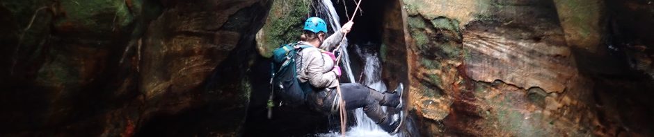
We came to a drop that you couldn’t down-climb, and didn’t look like you could walk around it, so, we decided to set up the rope and abseil it. This was a surprise, and definitely upgraded the creek from “nice” to a fun day out!

The rope wasn’t in a spot where it was easy to grab hold of if you were anyone other than John, so we attached prusik loops to it, Penny on the abseil, she made it look easy. When I did it, turned out to be a bit of a “tricky” start.

Trish on the abseil. I actually missed the rock that you could land on and ended up totally submerged.

I said “Penny, can you see how you can get over that rock, and what’s on the other side?” I thought she’d try climbing up and walking around on the left, but no, she bridged it – easy as! Trish and I climbed up on the right, our legs aren’t as long as Penny’s.

A compulsory swim after the rock.

John tried, and tried, to avoid falling in (or jumping).

To no avail!
There were a few more compulsory swims/wades, and we started seeing pagodas, but none of them looked familiar to me (which was what I was thinking I’d recognise and would indicate that we were close to our exit). We continued downstream and finally came to another pool and what looked like an abseil. John and I agreed that this is probably where we would exit, but nothing looked familiar, having been burned last year really changed how it looked. John thought he recognised the ramp we’d used, so headed up and sure enough we were at the exit point. We had lunch at 2pm on a rock shelf with a view.

Penny on the small down-climb that we had to do to access the next gully over and then we headed up to the tourist tack (to Lions Head).

I’d had a major blow-out with my Volley’s and doing the downclimb proved difficult with my foot virtually escaping from the side of the shoe. Sad, these were my last pair of Volleys, I will miss them – wasn’t easy completing the rest of the walk like this.
The tourist track initially wasn’t as easy to follow as it had been in the past, after the fire and the heavy rains of February, a lot of the track had washed away. When we got close to where I’d decided to go in to look at the second side creek and waterfall, we debated whether or not to do it, after all, the vegetation didn’t look that friendly. Trish decided to give it a miss, she’d go on ahead and drive my car to the exit track (avoiding a 15 min walk at the end for us).

John, Penny and I headed into the bush – make that the burned hakea and banksia – it was horrific. As Kathy (John’s wife says), it’s not a real bushwalk unless you have some horrific scrub. We persevered for what seemed like ages, Trish’s decision was obviously the right one!

And then John could see a hanging swamp up ahead, so we headed over to that. From there it wasn’t as scrubby to get to the head of the waterfall.

The waterfall was singularly uninspiring, much higher than the first one but not half as nice. There are big cliffs around it, forming an amphitheater. It looked like it would be hard to get down to the bottom with all those cliffs. The creek itself was pretty dry, but didn’t look scrubby, so maybe approaching it from below is the best bet, not that I’ll be doing that – have seen enough.
John found a much better route back to where we’d left our packs – avoiding all that burned hakea and banksia entirely – pity we didn’t find that route on the way in!

Great display of flannel flowers on the tourist track.
So, back on the tourist track and we high-tailed it to the exit, noting along the way marks that Trish had made to indicate that she’d “passed this point” – thank you Trish! Trish could instantly see that she’d dodged a bullet, we were all black-as from the soot.
As a day-walk, the first part of this trip was definitely worth doing – easy walking with lots of plunge pools and an abseil (or two if you include the first waterfall). From start to the lunch spot was 4 1/2 hours, then it’s roughly a 1 hour walk back on the tourist track to the fire trail. The tourist track in itself is worth the effort, lots of lookouts along the way. I wouldn’t consider doing the top part of the creek + the next two abseils (the BIG one), for me it would be way too long, the walk from the base of the big waterfall (45m) to the Lions Head pass takes about an hour – all up it would probably be a 9 – 9.5 hour day and not much bang for your buck.
Thank you so much Penny, John and Trish for coming with me on this exploration – was a great day out – except for that second part!