
WOLLEMI NATIONAL PARK – 26 – 30 October 2019
This was to be my epic Rambo Creek Expedition … if nothing else, this trip proved the value in continually reassessing the situation, being flexible and on-the-spot quick thinking. But sometimes the best laid plans fall in a heap.
Plan A involved a car shuffle positioning two vehicles at the locked gate on Grassy Hill Fire Trail and then Jeff would drive me, Murray N and Emma P around to the Zig Zag railway where we’d meet up with the rest of the group and then drive out to the Mount Cameron Fire Trail locked gate. We had to pack for 8 days walking in a creek, plus abseil gear. We also needed to take into account that we may not find water at the first campsite. My pack was weighing in at 18k (with 5l of water), I wasn’t looking forward to the prospect of a 14k walk to our first campsite, particularly as the temperatures were forecast to be in the high 20s. With little or no rain over the last six weeks, I was 75% sure that we wouldn’t find water, and therefore have to walk back to the Mt Cameron Fire Trail but that suspicion wasn’t enough for me to can the trip.
If we didn’t find water, Plan B was to do some canyoning around Annie Rowan Creek and would involve walking in with said 18k pack and have high camps each night, picking up water for the night in the canyons we did.
All was going according to Plan A until Jeff and I arrived at the Putty Road, about 20k outside of Windsor. I could smell the unmistakable smell of burning bush, and sure enough we crested a hill and there was a police road block due to a grass fire just down the road. Murray and Emma had driven through about 1/2 an hour earlier, so they were at the rendezvous. Whilst we could have taken another route and meet up with Murray, with the high winds that we were experiencing, I wasn’t keen to put the car shuffle in place, only to find out in eight day’s time that we were cut off by an out of control bushfire, so I canned Plan A.
Plan B wasn’t looking that great either, the thought of eight days of a dry camp wasn’t that appealing and the 18k pack was a worry! So, Plan C … we’d go to Glen Davis and do eight days of canyoning. Everyone seemed to think that was a much better idea than carrying their heavy (up to 25k) packs in the heat!
So, there was a bit of running around getting better food, alcohol, and some additional canyoning gear from Anna O-B, then we all met up at Glen Davis for a car camp … there were six of us, Anna O-B, John G, Jim C, Murray N, Emma P and me.
Sitting around after we’d all arrived, we decided that as we had overnight gear, we’d head up past Running Stream Creek to camp in the headwaters of Coorongooba Creek and check out some passes, particularly those in Trapped Canyon … Plan D.

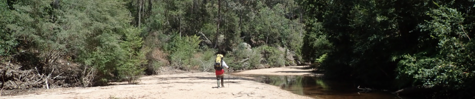
Just across the Capertee River and going upstream on Coorongooba Creek, there’s an old road that goes all the way to an abandoned mine, easy walking.

Was much easier walking in the creek than on the banks.
As we were walking upstream on Coorongooba, we heard helicopters, and eventually we were close enough to watch one picking up water in a “bucket”. Given that there was no smoke and taking into account the time it took the helicopter to make the round trip, we surmised that there was a bushfire over on Gosper’s Mountain, probably as a result of a lightning strike on Friday night. We weren’t too concerned, Gosper’s Mountain is about 12k away, plus, we couldn’t see or smell smoke.

Helicopter after picking up water in the bucket.
So, we continued on, found a good campsite and then headed up to Trapped Canyon (hard work to get to, a nice creek but that’s about it, we only went as far as the first climb, if there is anything beyond it, it would have to be bloody good to warrant a return trip!).

Walking upstream, still trying to keep our feet dry.

Eventually though it was just easier walking in the creek.

We’re past Running Stream Creek now, still hard going but did get the occasional rock slabs.

Heading down Trapped Canyon (unnamed creek), it was hard going up stream but we found a good route heading back, note to self, stay high on the right hand bank going downstream.
I spent the night under Jim’s fly worried about a Tiger Snake (that Murray had seen downstream) coming to visit us during the night.

The fly set up that Jim and I had wasn’t the prettiest, and in actual fact the weather was so mild with new dew, we could have done without it.
We got up the next morning and the valley was filled with smoke, not thick but definitely there and making everything look hazy. We decided that we’d best go to Plan E … walk back downstream to the campsite, if the Ranger had turned up and closed the campsite, he wouldn’t know where we were and that would mean him unnecessarily hanging around till we arrived (and therefore not being able to do fire-related stuff), or, we’d be locked in (highly unlikely). The helicopters weren’t working in the morning but by the time we were 1/2 way back to the campground, they were again picking up water.

Heading back downstream, in Coorongooba, we stayed on the left hand bank and got a much easier route than the previous day.

Back in Coorongooba Creek, heading towards Marathon Creek.
The campground was still open, and no sight of rangers, so we went to Plan F … stay at the campground. It was early so the others would go do Coin Slot in the afternoon and then do Bull Ant canyon on Tuesday and then Marathon on Wednesday. Then, when Louise arrived on Wednesday night, (subject to the fire) we’d head up to Freshwater Canyon, and then after that Mystery Creek, both overnight trips.
All went to plan (Bull Ant was great) but then on the walk out I sustained a nasty skin tear. So, we all went into Rylstone for dinner and I went to the hospital to have my wound dressed properly and get some antibiotics. Whilst at the pub, we looked at Fires Near Me and discovered that the bushfire had spread to 2,000 hectares, but still not close to us.
Wednesday morning at 7am they all headed off to do the full Marathon Canyon trip, it was exploratory so who knows how long they’d be gone. I didn’t want to get my dressing wet, so stayed in camp.
At 11am, the Ranger turned up to advise that as a precaution they were closing the campground, everyone had to pack up and go somewhere else. It was actually surprising that they’d waited so long to close it, the smoke haze hadn’t lifted at all. It was also fortuitous that I wasn’t off with the rest of the group doing Marathon as I was able to explain that I had no idea when they’d be back. He confirmed that the fire wasn’t so near it was a threat to me, and agreed that I could wait for the others to return, then basically “turn the lights off and lock the park” and call him on his mobile phone once I got reception to confirm we were all out safely. Apparently, fire breaks were being built and back burning was underway. They were also building helipads up on the ridges in preparation for firefighters to be dropped in by helicopter. Again, it was fortunate that they closed the park on this day, otherwise we could quite easily have been up in Freshwater Creek for two days and they wouldn’t have a clue where we were!
By 6pm, when the others still hadn’t returned I was looking at my options and decided that at 7pm I would drive out till I got reception and then call the Ranger and explain the situation and tell him that I’d have to wait for the others, and that it might be well after dark when they made it out. Half an hour later the group of explorers turned up, we struck camp and headed for the gate and Plan G – meet up at Wallerawang Pub for dinner to discuss our options. We arrived there just on 8pm and I was worried that we’d have to go with Plan H if the kitchen was closed, thankfully it wasn’t.
So, we considered all the options, I had decided that without the ability to do wet canyons (cause of my bandaged arm), it was too hot for anything else and I’d go home. That pretty much did it for everyone else, they mostly decided to head home – after all, they’d done 3 good canyons, can’t top that!

A map showing where we were on Monday night and where we were car camping.

Map as of 2 November showing the extent of the fire. When I looked on Monday night, just 900 hectares had been burned. As of Saturday 2 November, 8,000 hectares have been burned. Each day when I’ve looked, another 1,000 hectares have been burned, with no end in sight.
Edit: 3/11/19 – 9am 9,830ha burned.
Edit: 4/11/19 – 7pm 10,279ha burned, maybe slowing down.
Edit: 7/11/19 – 4pm 15,753ha strong westerly winds today.
Edit: 8/11/19 – 1pm 18,847ha
Edit: 10/11/19 – 3pm 25,770ha
Edit: 11/11/19 – 4pm 30,417ha
Edit: 12/11/19 – 7pm 45,401ha
Edit: 13/11/19 – 7pm 61,882ha
Edit: 14/11/19 – 5pm 71,883ha
Edit: 17/11/19 – 7pm 122,840ha
Edit: 22/11/19 – 5pm 185,980 ha
Thanks so much Jeff for helping to set up the car shuffle, thanks to Anna for dragging out all her canyoning gear and sharing it with us and thanks to Murray, Emma, John and Jim for taking everything in their stride. But for the absence of rain and extraordinarily hot weather, Plan A was a good one!
Sounds pretty scary to me! You be careful this summer M!!
Wasn’t scary then, but would be now that the fire is getting closer to the campground!
Guess its back to plan A next year let me know if you need a hand with the car shuffle.
We’ll see, might have to leave that adventure for the young’uns
WOW! That is quite a story! I was aware of the fires there because one was near Tuncurry where Gillian lives. Do not know if that was the same fire you talked about.
I always have to convert Metric to understand how many pounds and miles you are talking about! As you know 20 degrees there is quite different than 20 here!
Woke to snow on the ground this morning. And so it begins for the next 5 months.
Expecting colder than normal. Back to your story—— I always love the names of the places you visit. The aboriginal especially. But sometimes I question the wisdom of going into something called Trapped Canyon when there are fires present!!🤪
Not sure what a Tiger snake is , but do not want to encounter one!!! Despite that your adventures sound like so much fun!!! I started working out at the Y this week. I figure that in about 2 years I might be able to keep up with you!!! Thanks for sharing this adventure.
Hope your arm heals nicely!!!
Well, the fire was a long way away at that point, would be inadvisable now, in fact looking at the map today of where the fire is, it’s on the ridges surrounding Trapped Canyon, but not in the creek, would be scary now though!
hi M is trip still on bucket list ? or moved on to next adventure on list?
how is your arm
Arm is ok, not sure about the trip, we’re talking about a couple of recces, it’s all up in the air due to lack of water, I’d try to do it again but only if there was guaranteed water, and someone along to carry a bit of my food (lol).