 NEWNES PLATEAU – 15 September 2019
Our second day’s canyoning was a canyon I’d wanted to do for over four years but just never had the opportunity. It’s an unpublished canyon, but for this post we’ll call it Portal Canyon. Mind you, it’s been done to death lately, so everyone seems to know about it, but still probably a good idea for it to be “relatively” unknown.Heather, Bill and Alan had fed me a gourmet meal the night before and then to top it off, Alan served me bacon and eggs on Sunday morning – only problem is the bacon made me really, really thirsty and I must have drunk half my water on the walk in (note to self, don’t eat bacon before you go out into the bush on a hot day!).
Four of us set off from the track head and Anna met us half way along, she’d walked in from a different direction. We managed to all rendezvous in the bush, no mean feat! and then set off on a very faint footpad.

Anna and Heather had both done this canyon (quite a few times), so Anna led the way (holiday for me after yesterday). At this point we decided that we should head down into the creek.

Pretty easy going, a small amount of scrub but nothing like the previous day.

Anna was absolutely thrilled that she took us straight to the first anchor – no hunting around!

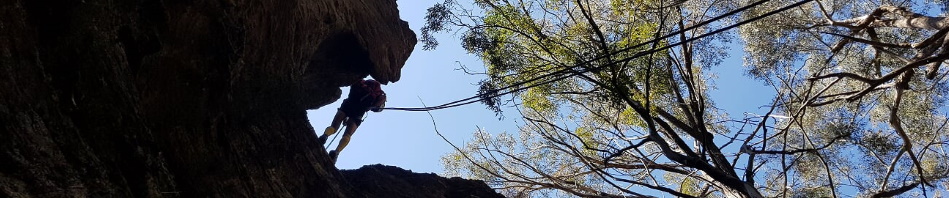
Bill rigged the rope, it was the rope’s first adventure and was very stiff and tangled easily. (Photo: Alan G)

And then we all abseiled down, was a bit of a chute, Alan didn’t seem to think it was all that narrow.

Me at the top of the abseil, the first part looked really narrow to me, but then I got down to this bit and wondered how the hell I’d fit through the hole WITH my backpack. Bill did a great job of deploying the rope through the hole! (Photo: Alan)

Getting through the hole wasn’t as bad as I thought it would be (Photo: Alan)

Bill on the abseil.

After the abseil, we walked down a short way and there was a very, very large cave, formed by water flowing through the creek, it would have been about 30m long and about 10 – 15m deep, quite impressive, you definitely needed a torch to get through without tripping up.

The creek was a little scrubby, and at some times it was difficult to see what route you should take, but Anna remembered this slide down the rock.

More scrubby bits and then the creek closed in a bit more.

Then we came to our second abseil, very short, over a chock stone, almost landed on a water dragon.

Me at the top of the chock stone abseil. (Photo: Alan)

Bill on the chock stone abseil …

… which is closely followed by the next abseil – me about to go down (Photo: Alan)

Alan at the bottom of the abseil, trying to understand the directions we’re giving him!

Heather on the abseil (I changed the exposure settings)!

At the bottom of the abseil there is a pool, which “usually” is full of water and cayoners sometimes play the “Water is Lava” Game. They either slide through the slot/ledge (if the water is really high), or bridge from one side to the other, until they get to where I’m sitting. On this occasion, with the exceptional dry weather we’ve had, the pool was absolutely bone dry, so I was able to abseil all the way to the bottom and then climb out. (Photo: Alan)

We had a quick lunch and then tackled what we thought was the last abseil. This one is about 27/28m. Iwas pleasantly surprised when we found yet another anchor.

Most of us (probably everyone except Anna) were complaining about the speed of the new MSS rope, it was way fast. Despite gloves, we still had very hot hands, (probably should have taken more time on the abseil). Bill didn’t have any gloves with him (left them at home), so Heather pulled out her second pair, the pink does look good on Bill, and now he’s wearing all the primary colours!

Alan on the last abseil, and what a view!

And what a great abseil, had everything going for it, nice walk down the slab and then a couple of small overhangs.

Bill with the pink gloves finishing the abseil.

From the base of the cliff-line it was straight down. Sometimes with an abundance of leaf litter it was just easier to sit on your butt and slide down!

We left Anna down the bottom near the River and the rest of us walked along a track to get back to our cars. There is an alternate route that you can take, but I was ready for a couple of hours without thinking about where we should be going. Plus, as Heather said, using this track means that you can look around and check out the scenery more (and in my case look at the map to try to see where we’d come through the cliff-line – hard to pick!). (Photo: Alan)
Car to car it was around 7 hours, probably could have shaved some time off that, but we weren’t in a hurry and stopped a lot to admire the scenery, plus it was a hot day and the last up-hill climb was punishing, I got slower and slower. Fortunately, we found a spring that was running clear water, so we were able to fill up our water bottles, and drench our heads with water to cool off.
Thank you Bill, Alan, Heather & Anna (who’ll both go anywhere with me) for joining me this weekend, it wasn’t quite the adventure that we’d planned, and the exploratory part was horrible, but we still had a great time.
And David S, you would really have enjoyed this day, but definitely not the Saturday!
Looks rather like the western side of the Newnes Plateau (Wolgan side). Almost time for some wetter canyons. Some interesting photos!
It just might be Lindsay. Yes, getting ready for some wet canyons, you up for any this year?