 WOLLEMI WILDERNESS – 29 & 30 June 2019
Putty Road > Kooroo Creek > Tinda Creek > Culoul Creek > Culoul Range Fire Trail
I’ve always admired those early bushwalkers who explored the Colo/Wollemi Wilderness without a GPS to back them up – just using a map and compass. It only takes one small thing all expectations of where you are on the trip can be wrong, why we don’t hear stories of huge errors on their trips is surprising. This was one of those trips, not that it involved us getting lost, but my expectation of where we were did add a further 4 hours onto our trip on Sunday. But, more about that later …
This was a trip that I’d planned last August, we ended up only doing a part of the walk as, only 2 hours from the car, I was knocked over by a falling rock and we decided to call it a day and go home. I’d always intended going back and doing the full trip, Jeff agreed to navigate it for me and Trish M (who’d been with me when I’d taken the fall), Heather (who’ll go anywhere with me), Brad and Bill (Mule), joined me. At 9am, we started from Putty road after setting in place a vehicle at the end (thanks Peter T for giving us the Prado).

Glorious weather! The start of the walk was dead easy, nice open country, I suspect that at some time in days gone by, this whole area had been logged, not many big trees around, and they probably ran cattle on the land, although that might not be the case as there weren’t many weeds.

Before long we were ready to drop down into Kooroo Creek (this would eliminate some circuitous route changes). The way down looked pretty easy, nice widely spaced contour lines.

We came to a small drop through a minor cliff-line, but nothing that the trusty tape couldn’t handle.

The route took us down to a ledge, you could either walk along the base of the cliff, or drop down another small drop.

Heather chose to drop down (with the aid of the handline), I walked along the base.

The drop was followed by more gentle slope and then we crossed the very small, dry, creek.

We had picked out a route that was also fairly easy going up to a saddle, another small climb up the top, didn’t need a handline for this, but on all the climbs we’d found so far, the rocks were very loose, so each of us had to wait (outside the fall zone) for the person in front to get to the top before we could proceed.

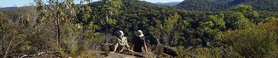
We were at Gibba Trig by lunchtime, took the obligatory photo and then sat on a ledge overlooking Mellong Creek. I was actually surprised that the trig was still standing and in such good shape, there’d been fires through the area a few years ago, but must have missed this part of the NP.

After lunch, again, the vegetation was very friendly and the going pretty easy. We did have to pull Jeff and Bill up for walking too fast, we weren’t looking at any of the scenery, too busy trying to keep up. They “sort of” agreed, but it was still a fast pace for the rest of us.

Although we were walking along a ridge there were a few ups and downs, a lot of them involving small drops with now option but to down-climb.

Nice viewing platform down into Mellong Creek, at this point we are at about 460m above sea level, and about 300m above the creek.

We then came to a lovely section of rocks, with easy access down to the next level.

Jeff on the easy ramp down.

This took us to a saddle.
At the saddle, we were about 1.5k from our destination, but I looked at the map and the thought of climbing up another bloody 100m up a hill, just to go down the other side to our campsite wasn’t appealing, so I looked at the map and suggested to Jeff that we contour around from the saddle we were in and avoid the 100m climb, this contour (about a k) would take us to a spur and then down to the junction of Tinda and Wollemi Creeks.
Neither Jeff nor I like to use the GPS on trips, we take one, but prefer old school map and compass work, so that we wont lose those skills. I did however, get Jeff to check where we were on the GPS, it was getting late in the day and I didn’t want us to waste any time.
Whilst the idea to contour around the hill was a good one, it didn’t quite turn out that way. Anyway, we started contouring, but also started dropping quicker than we realised, I wasn’t paying attention to how far we had gone, or how quickly we had dropped to a cliff-line, if I had been paying attention, I would have realised that we weren’t far enough along. Anyway, we found a cliff-line, then we found a way down through the cliff-line and dropped into the creek

Brad after some dodgy traverses and down-climbs, just going down the last few metres.

Brad on the very slippery rock slabs in Tinda Creek.

Bill on the slabby creek banks, I was hoping the whole creek would be like this.

But then it turned boulder, not so nice.
We walked about 300m downstream and came to a creek junction (what I expected to be the junction of Tinda & Wollemi Creeks). This looked like a good campsite, and from the map I knew there was a pool of water (as the campsite was dry), upstream in Wollemi creek, about 100m. We walked upstream and there was a pool of water, not as deep as I was expecting, but a big pool where we picked up water for the night and the next day.
All of this was what I had expected, I didn’t even consider that we might not be where I thought we were.
We were all pretty tired, but managed to collect a good supply of (wet) firewood, and then settled around for dinner. Once the wine/brandy/butterscotch schnapps & vodka and lemon juice was exhausted, most of us went to bed to get a good night’s sleep.

Brad’s tent – as a weight saving measure he’d intentionally left the poles at home and used sticks, pretty good engineering – but I think he forfeited the fly too, and got a bit wet during the 3am shower that we’d had.

Our campsite next morning.
With our assumption of where we were, we looked at our alternatives for getting up onto the ridge we wanted, initially we’d thought about going downstream for a k (in the “Wollemi”), but then Jeff had found what looked like a good ramp up the spur behind our campsite.
It was at this point that Trish looked at her GPS watch and said, the car’s that way South West (pointing to the spur to the right of our campsite), no, no says I, we’re going South West (pointing to the spur to the left of our campsite). I was so sure of our position that we didn’t take the time to double check.

So, we headed up the spur, which was really easy going to start.

Then there was the occasional up-climb.

Followed by another ramp.

And more climbing, but nothing like we’d expected.

And more climbs.

Nice ramps.

Getting close to the mid-way point in the spur.

We stopped at about the 350m contour of our hill for morning tea and to admire the views.
It was at this point that I asked Jeff to check the elevation and I asked for a GR of where we were. Jeff’s GR didn’t put us where I thought we were so I asked Trish to check hers too, as from my map, it looked like we were 1k to the East of where I expected we should be.
It turns out that we had camped on the intersection of Tinda Creek & Culoul Creek. Everything was as it should have been and as I’d expected it to be, except we were 1k upstream of where we were supposed to be on the intersection of Wollemi Creek. We’d dropped down too quickly and had not travelled far enough along the contour on the previous afternoon – would I have picked this up if I’d been paying attention? Would old timer bushwalkers have picked this up? Probably. As it turned out, this was a fortuitous error, as if we’d followed the original route, we would have been going down the spur to the Wollemi/Tinda junction in the dark!
And my “bad” for not looking at the map and getting a GR off Trish when she’d said we should be going South West while we were still in camp.
So, if we kept along this ridge, eventually there’d be a creek crossing and we’d end up about 2k from our vehicles on the fire trail. We decided to do the creek crossing earlier and get back onto our original route. All we had to do was to get above a cliff-line and we’d be home and hosed as they say.
We climbed up another 150m and came to a cliff-line, Jeff took a quick look to the left and I went looking along to the right for a way up. I said there was an ok way and everyone came towards me, in hindsight, we should have gone the way Jeff wanted to go.

Jeff and Bill didn’t like my way up, so we kept on walking along the base of the cliff. It was pretty obvious we wouldn’t find a way up, so we elected instead to find a way down, we were on the mid-level of the cliff face, so it wasn’t going to be easy.

Eventually we came to a ramp and Jeff said that we could get down from that with use of the tape. The vegetation and rocks were very loose, so we had to be careful at every step to make sure rocks didn’t rain down on those below.

Jeff setting up the tape. When he got down the first level he found that the tape wasn’t long enough to get us down to the next level, so we used one strand of the tape only, tying it off on a tree. The last person, Brad, would have to untie the knot and put it on a tree further down.

Nice shot of everyone on the ramp, spaced out so we wouldn’t loosen rocks, Bill, Brad, Heather and Trish that you can’t see right at the top.

Bill going down to the first level.

The second level, you had to sit on the bole of this big gum and drop down.

Heather, Bill and Jeff are having a great time with all the climb-downs.

Brad dropping down after he’d retrieved the tape for me.

The route down was quite steep, this was what looked like a waterfall, we couldn’t climb down it so skirted around it.
Eventually we were in Culoul Creek and ready to head up the other side to our target ridge. We were lucky to find a relatively easy route up.

The tube tape only had to come out once for this small chute and climb at the end.

After the climb there was still a fair amount of up to go to the ridge, and then two or three small knolls that Jeff chose to contour around as we were all pretty tired by now and not relishing any more up-hill.

Bit of wood I found in the bush covered in purple lichen – haven’t ever seen purple before.

About 2k from Culoul Range Fire Trail, we happened upon an old fire trail, well, not that old, I suspect it was less than 5 years old, and put in to fight a fire in the Wollemi/Putty Road area. None of the sapplings were big. The trail was heading the right way so we took advantage of it. It’s not been used recently, and when we got to the end (near where we’d parked Trish’s Prado) we could actually see it, but you really wouldn’t know it was there unless you were looking for it. Bonus for us though.
So, we arrived at the car at 4pm, I figure our 2.5k detour up the wrong spur and then over to the right one, cost us about 4 hours but then again, who knows what obstacles we would have encountered if we’d taken the spur to the South West rather than the one to the South East. At least now we know that that’s a viable route, not that I ever intend going back to that campsite again (lol).
Lessons and things I learned on the trip … I’m not an old-timer bushwalker, check the GPS when you make camp (lol) and don’t make assumptions. Culoul and Tinda creeks are both dry and sandy, so it’s highly unlikely that you could rely on water in either of these creeks, except for the pool that we found 100m+ downsteam on Tinda from the Culoul/Tinda junction. Tinda Creek is very rocky and because it doesn’t get much sun, the rocks are incredibly slippery. During June/July (shortest daylight hours) 10k off track is too much, I should only expect to be able to travel 7k at the most, and even during longer daylight hours, 10k is the most I’d want to do now, I was stuffed when we got into camp.
Will I go back to the area? The jury’s out on that, I do like the area, I love negotiating through cliff-lines, and the ridges were nice and open. Would I be able to convince anyone else to go back, well, maybe Heather and Bill but I seriously doubt the others would be up for another trip!
Thanks everyone for coming with me, ticked another trip off the wish list!
Hmm:
For piece of cake, read “Rocky Road”
Exactly, we need to sit down over maps to determine where you went on past trips!
great photos and story Marilyn
Thanks Michael, have a love/hate relationship with the Colo/Wollemi wilderness. Plenty left to explore though.