 MOGO CREEK AREA – July 8, 2018
When planning a walk, half the fun is talking over the route, discussing the options and debating the assumptions that you make. My usual walking partner, and who I rely on to call me out on sketchy assumptions, is taking a break so I was left to my own devices – turned out that pretty much every assumption I made was wrong!
I asked my daughter-in-law Tanya if she’d like to do a walk with me to look for some aboriginal art, and when she agreed, David and Bailey said they’d like to go too. As my grandson Bailey was the only one with any off track experience, I wanted a few more experienced people on the trip so I put the word out and Helge L, Grant and Paula B joined me. Whilst Tanya and David had done a very small off track walk with me, this would be their first full day of off-track adventuring.
We started off from Mogo Creek Road to an area I’d not been to before, armed with the maps and four grid references to find some special places. It was bitterly cold and a gusty wind was blowing, my fingers were crossed that our first creek crossing (as soon as we left the cars), wouldn’t be too deep. Luckily it was just ankle deep, and we took our shoes off because the rest of the trip would be dry. However, the water was FREEZING!
John K had kindly given me four grid references, a site with axe groves, an “interesting slot”, a habitation cave and a cave with aboriginal art in it. I didn’t know whether the grid references were AGD66 (mapping in the 1960s) or GDA94 (using data from the 1990s). The difference is 100m in the “eastings” and 200m in the “northings”, doesn’t sound like much but out in the bush it is considerable. Assumption #1: As my map uses GDA94, I guessed (and hoped) that the grid references were GDA94. When I plotted them on a map, they all looked in logical places.

Our first objective was the aboriginal axe grinding groves. Assumption #2: Axe grinding groves would be in the creek, where there was water (which is used in the sharpening process), so we headed upstream on a small side creek in the direction of the grid reference.

The going was a little slow with lots of boulders to negotiate through.

No water in the creek and the boulders were getting bigger.

Bailey checking out a cave to see how far it went in under the boulder.

By now the creek is opening out and is actually nice country but the spots where there would be rocks and water nearby were getting scarce the further upstream we got.

Nice campsites though (pity about the lack of water).
It was at this point that I killed Assumption #2 that the groves were in the creek. Assumption #1 also went out the window, so I sat down and changed the datum on my GPS to reflect the AGD66 and voila! the grid reference moved away from the creek, 200m up onto the ridge. I’d had enough of the GPS by this time (I’ve had to change the screen twice due to breaking it, and for some reason the grid display isn’t working, fortunately though, the map and waypoints were visible). So, I handed the GPS over to Bailey so that he could track us to the waypoint (David wondering at the wisdom of handing the GPS over to the youngest member of the group – but it is technology and Bailey’s a wiz at that).
So, he led us away from the creek and up hill, unerringly taking us to a lovely big flat rock. When I arrived there (taking longer to walk up the hill), he was wandering around on the rock, not really knowing what to look for.

David & Tanya on a “leap of faith” getting from one boulder onto the slab (I think I heard the words “Tanya, stop pushing me”).

I don’t know why I assumed that the groves would be in a creek, I’ve seen them on slabs before. They weren’t very deep so perhaps this spot wasn’t used that much, but nevertheless, there was the water and the groves.
With Bailey and the GPS in hand, I’m on a sure thing, so give him free reign to take us to our next objective “an interesting slot”. Grant, Paula and Helge stayed on top of the ridge, the GPS took us down into the scrub – in hindsight we should have stayed on the ridge, but we all arrived at the top of the ridge eventually.

After battling the scrub, we’re now on the ridge with great views down into the creek we’d be walking up (it’s a long way down though!). David and Bailey near the edge making Tanya and me very nervous.

The view down into the creek. Another 30m and we were at the interesting slot.

You couldn’t tell whether or not there was a drop at the end so we sent Helge down to make sure it “went”.

Tanya took one look at this slot and was not keen, so I whipped out the tape to set up a handline to make her feel more secure. We had to leave a lot of space between people as there were lots of lose rocks.

Tanya looking a lot less nervous.

Set up a second anchor for this bit as there were loads of step downs with not much to hold onto.

I was hoping there’d be a nice section of cliff that we could walk along the base of until we reached a more gradual spur down to the creek, but we weren’t that lucky.

It was very steep and we were in and out of a gully, a lot of our time was spent bum-sliding!

Finally we’re down off the treacherous slope and on flat ground heading upstream.

We then dropped down into the creek – how nice was this, wide, flat and no rocks!
We stopped briefly for lunch (and boiled the billy) and decided that we’d head upstream for an hour and if we didn’t find the cave, then turn around at 2.30pm (as the route out would take us over 2 hours and it was getting late).

Occasionally when we got to a boulder section we got out of the creek, but still easy going.

Despite getting into some fern covered ground, the going was still easy.

Lots of nice camp sites.
We reached the spot in the creek where the GPS (still in Bailey’s capable hands) showed that we were not far off the waypoint. My notes (from a report to the Anthropological Institute in Great Britain & Ireland dated 1895, stated that the cave we were looking for was 80 yards on the right hand bank of the creek. Assumption #3, I assumed the right hand bank was looking upstream on the creek. The GPS indicated that it would have to be on the right when looking downstream.
With time getting away from us, we took a punt and decided to go follow the GPS and go up hill for 80 yards and see if we could see anything. David and Tanya stayed with the packs (I gave them a walkie talkie so we could communicate), and the rest of us set off.

In no time at all Paula calls out that she’s found an overhang so we headed over to her and sent word down to David and Tanya to make their way up.

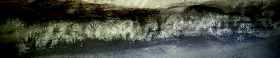
The Anthropological Institute Report indicated that the cave was 33 feet long, 10 feet deep and 6 feet high at the entrance and this cave fitted those measurements. However it made note of a red-ochre figure of a man on the back wall. We didn’t find this figure, just lots of hand stencils. Mind you, the report is dated 1895, 120 years ago, maybe art was layered over the top of it, who knows.

Lots of hand stencils, close to the ground and up across the ceiling.

A curious red ochre figure maybe, with a head-dress (maybe).

Another curious drawing.

An adjacent wind eroded cave with lots of white powdery sand (maybe used in the stencilling).
Running out of daylight hours we headed back to our packs for the walk out. My plan was to walk up to the ridge and then make our way back to where we’d crossed the creek. Helge came up with a better plan though, why not just walk down the creek, which so far hadn’t been too scrubby. Looking at the map, this sounded like a better idea than climbing up 150m to the ridge (which would be slow going). The new route would mean we’d have a 1k road bash but if it was twilight this would be better than bashing down a spur in the dark.

We retraced our steps back to the lunch spot and continued down stream, until I made the mistake of saying that “this is great, no boulders”, then we came to a few boulder strewn sections, but it was still pretty easy.

Bush walking is a full body work-out what with going over and under logs, some are just too high to step over.

On one section where Tanya and I were out of the creek on flat ground, we found a Satin Bower bird’s bower with the trademark blue souvenirs. Who would have thought there’d be that many blue things in the bush, the Bower bird must have flown a long way with these blue souvenirs in his beak, at least a couple of k.
As soon as David asked how much further and I answered another few hundred metres, we came across a dirt road, and so the going was much easier.

And shortly after that we arrived at the Mogo Creek Trail and it was just a little over a k back to the vehicles.
We were back at the cars at 4pm. We’d nailed all our objectives with the exception of the habitation cave which I’d decided not to visit as we were slightly behind schedule after the axe grinding groves. So, guess I’ll have to go back another day to find that!
Thanks so much Paula, Grant and Helge for coming along on the trip and particularly to Helge for suggesting the exit down the creek – was soooo much easier.
The Scotts were all pretty stuffed by the time we were back home so we braved the icy cold wind and hopped in David & Tanya’s hot tub – would have to be the best end to a walk I’ve ever had!
For Tanya’s and David’s second off track adventure with me it was an amazing effort, I definitely took them both out of their comfort zones – and Bailey, you were a legend with the GPS! Maybe next adventure I’ll get the other grandkids out with me!
Apropos grooves:
There are a lot of grooves on the top of Ironpot Mountain and the nearest water (?) is Coxs River ca 300m down!
I’ve usually only seen them by water, but good to know that they can be away from it too!
When asked if i wanted to go for a walk to look for aboriginal art, I thought that sounds great a nice easy walk, get outdoors in the fresh air and look at some aboriginal art.
I should have known there is no such thing as an easy walk with Marilyn ( a woman in her 60’s canyoning, caving, walking for days on end in the bush, scaling up cliffs and scaling down). How hard could it be??
We all had a great day despite me slightly freaking out about the slot, and it definitely was a full body work out (had no idea what a slot was until yesterday).
Bailey did a great job on the GPS 🙂
Thanks for taking us 🙂
🙂 well at least we have a benchmark now, in the future you can ask “is it going to be harder than Mogo?” Exploring though, how can you tell!
Well done to the Scott’s and the rest of the party, sounds to me like I can hang up my Boots and let Bailey take over from here!!
Not yet you don’t 🙂
Good walk and great photos. Well done to all.
Adrienne D
Thanks Adrienne 🙂
Another fabulous adventure with M….albeit from my armchair! Thanks for sharing your great outdoors.
Thanks Leanne! 🙂