 MOGO CREEK AREA – 23 & 24 June, 2018
Four years ago, Trish N, Jeff and I visited a side creek in the Mangrove Dam area and I always said that I’d lead a beginners walk back there, the campsite was THAT good. So, I decided that my knees were ready to be tested on an easy walk, plus I’d hunt out an aboriginal art site that I’d been given a grid reference for. Helge L, Steve R, Trish N, Heather R and Mike W (the only person that could remotely be called a beginner) joined me for the weekend.
The goal was to walk to the vicinity of the art site, hunt around, find it, then make our way to our camp site for the weekend. Heather came up with the suggestion to go to the campsite first, set up camp and then hunt for the art, sounded a much more civilised route, given that we wouldn’t be carrying our heavy packs for the afternoon, so we changed the plan.
Steve was a little late, for the first time relying on SatNav to get him to the campground, only to find himself on Boree Trail, many ks from where he was supposed to be, nevertheless, he eventually got there, then we set off. Despite a lot of rain the week leading up to the walk (which we figured was a good thing – probably water beside our campsite), the weather co-operated and was absolutely stunning as we set out.

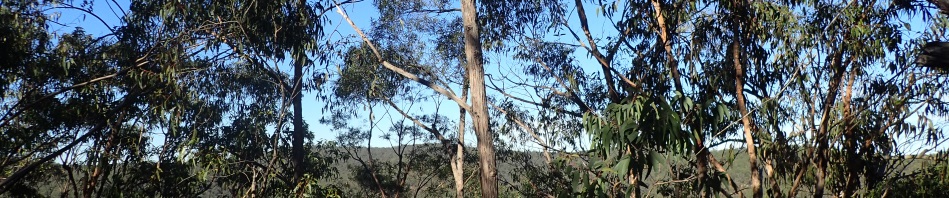
Dead easy route along a ridge for the first k or so, then we prepare to drop down into our first creek.

A few rocky drops to negotiate.

But overall easy going for the first section with quite a few level spots.

Then the terrain became steeper, but nothing that we couldn’t handle.

Dropping down into the main creek, which at this point looked good enough to be a campsite, flat and shaded, but I was on a mission to go to a campsite I’d spotted years ago.

The walk upstream in our side creek was easy. In the past when I’d visited this area I hadn’t walked in the creek but this time I wanted to see what it was like. Heather & Michael taking a rest waiting for the rest of us to catch up.

All the way up the side creek we were on the lookout for water. There’d been over 40mm of rain in the previous week but the side creek was dry-as with just the occasional puddle such as this. I took about 8l out of this puddle to use and when I went back next morning to get more, it had drained away and I had to go further upstream. On a previous day walk, Trish and I had spotted a big pool in this creek and I was confident that that would be our water supply. On this trip though, that pool was bone dry.

We finally arrived at our campsite and set up our tents for the night, very level, heaps of space and in amongst gum trees. The campsite was as good as I’d remembered it.

Camp set up and sitting back for lunch with a cuppa, all by 1pm, eat your heart out Jeff, the easy walk with me that you’ve always wanted and you weren’t there to enjoy it!
After lunch we set off on our quest to find the aboriginal art that I’d been told about four years ago. Unfortunately all I had was a 6 digit grid reference which I plugged into my GPS. We didn’t know if it was a rock engraving or a cave picture, but we did know that it was two emus and a birdman. We set off from the campsite and climbed a spur to the ridge I thought it was on. I split the group in two and half went and explored the base of a cliff line (looking for likely caves), Steve, Michael and I explored the ridge looking for big expanses of rock that may have an engraving on them.

The ridge was lovely and open (easy walking for us.)
When we got close to the end of the ridge, I took out the GPS and the waypoint that I’d plugged in, directed us into the creek, so over we went.

Into the creek, a nice little drop and then we went up the other side, always following the route to the way point. Up on the ridge and then over the other side. It looked like a likely spot, it was in full afternoon sun and there was a line of cliff.

Some of us dropped down checking out the cliff, others stayed on top.

We poked in every cave, and found NOTHING!
Eventually the time had come to end this fruitless search, would have helped if I’d had 8 instead of 6 digits in the way point, and to know whether it was cave art or rock engravings. All in all it was like looking for a needle in a haystack. We gave up and headed back to camp.

We walked the length of the creek back to camp and again, not a decent water source, other than the odd puddle.

While the others picked up water I set the fire as it was starting to cool down. Plenty of wood around.

Trish ready to put her salmon in the fire to cook.

Michael carried in a chair for round the fire, I was a bit envious!

Steve carried in five potatoes which he cooked in the coals and shared with us – with the butter that I carried in, they were delicious.

Next morning, just after sunrise, the Blue Gum forest that we camped in, stunning and it seemed to be the only stand of Blue Gums in the creek.

Warming ourselves around the fire, interestingly it wasn’t as cold during the night as we expected.

A bit later than intended (9.30am) we set off downstream to our next destination, the Sun Cave. Obviously at some point in time this creek had a lot of flow because the rock edge on the left hand side has eroded quite considerably.
We dropped our packs on the creek and headed up a spur to the Sun Cave, which we’d visited on a few other occasions.

The painting looks like a sun, but Helge assured us that this symbol indicates that the area is the venue for corroborees, people coming from all different places and meeting in the middle. There was another sun painting beside it but quite faded and not as clear as this one.

The faded one.

Helge thinks that this is another sample of art, but I have my doubts.

We did however find a hand stencil this time which we’d missed on the other two occasions.

Michael at the entrance to the cave.

We scouted out some other caves on the same elevation, this one had nice wind erosion.

And this one was quite big, makes you wonder why one cave has art in it and others don’t.
We retraced our steps back to the creek, had morning tea and then headed up to our exit ridge via a route that I hadn’t tried in the past.

Initially it was quite a gentle rise, but then became much steeper with a few sections of rocks to negotiate our way through.

By now it’s very hot and with climbing all the time, we took a few stops to rest.

And more climbing.

And finally on the top, Helge and Heather looking around for any engravings, you would think there’d be some up on this massive rock, if I were an Aborigine with nothing to do, I’d be doing some carvings up here – great views!

The rest of us had lunch in the shade, you can see in the distance there’s more rock, but no engravings there either.
The route back was pretty straight forward except for the end, every time I’ve done this route, I’ve gone a different way, this time was no different, except for the fact that only Trish and I took this route (which wasn’t too bad), the others went a more circuitous route though a lot of scrub.
We were back at the cars by 3pm, a very early finish for one of my walks! And, it wasn’t an epic!. We didn’t find what I was looking for, but it was great weather for walking and we did meet two of the three objectives (camp in the Blue Gums and find the Sun Cave again). Thanks so much to Steve, Helge, Michael, Heather and Trish for joining me.
I’ll probably have to go back again and look for those bloody two emus and bird man, will try to get more information though!
Ta
Bit fragile, sliced n diced this week : SCC + BCC
Ahh, hope you are ok, but better off, don’t worry you’ll be back walking soon.
Great report…fantastic campsite!
Yes, I did tell you it was fantastic, you could have come and tended the fire while we were hunting!
Its a nice spot, where did you make your entry from