 ETTREMA WILDERNESS – 29 March – 2 April 2018
Greta Road > Rogers Hill > Cinch Creek > Billys Hill > Billys Pass > Hamlet Crown > unnamed spur > Ettrema Creek > Tullyangela Creek > Puckett Pass > Pinchgut Hill > Cinch Creek > Tilly Anne Gap > Possibility Point > Tilly Anne Gap > Greta Road
This was a walk Jeff did 7 years ago and he thought that it was so good that I should do it – he admits now that he’d forgotten about some bits over the years (don’t we all?).
Steve R, Murray N and Emma P joined Jeff and me for the walk. We met at Greta Road and set off at 8.10am on Thursday morning (we had all added an extra day to the Easter Holidays).

We left Greta Road and followed a disused fire trail for the first 10k or so. Over the 5 days, we talked about what it would have taken to find all the cliff passes that we used. In hindsight though, those that explored the area would have been able to drive out on almost 22k of this fire trail, set up a base camp with all mod-cons and then poked around, those were the days!

We found this dinner-plate sized fungus, when we returned decomposition had commenced and it was desiccated and dried out.

On Jeff’s previous trip, the group had gone around to the south of Rogers Hill, this time Jeff took us to the north of it with the intention of avoiding some scrub, and in the main we did, picked up a few of these rock slabs along the way to avoid some of the denser vegetation.

Looking down our unnamed pass into Cinch Creek

Emma and Murray, looking keen to get down to the creek.

So far the way down is looking good.

We came to a drop off so Murray scouted around on the pagodas looking for a way down.

We dropped down a level with Murray’s hand-line, then skirted around to a slot.

We’ve called this Skinny Woman slot, you had to take your pack off to get through.

Jeff and Murray coming through.

A nice overhang after the slot and under the pagoda.

Jeff walking into the cave.
The route down to the creek was uneventful and we were all really, really hot. My Ettrema Guru, Geoff J, wasn’t sure that we would be able to pick up water this far up Cinch Creek. We’d always thought if we didn’t find water where we dropped in, then we’d just go downstream a-ways. As it turned out there was a big pool of water, right where we dropped into the creek. By this time we’re really hot, so we took the time to sit in the shade, fill up on water and then each carry an additional 4l+ for our high camp that night as there wouldn’t be any water nearby.

The climb up the other side of Cinch Creek was uneventful, just finding our way through the cliff-lines, we came across another Skinny Woman slot, the guys were just sitting there watching Emma and me, they must have found an easier way up!

Getting out of the slot was tricky.

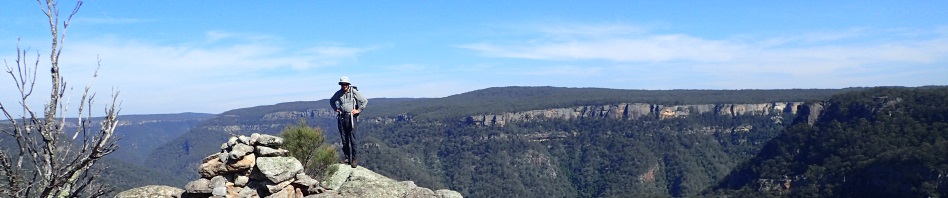
Finally up the top, we took the time to take in the views. Looking across at Rogers Hill from where we’d come.

By now it’s getting late and we have about 2k of scrub to get to our proposed campsite for the night, in the vicinity of Billys Hill. We tried to avoid scrub and found a few rock slabs but in the main it was pretty scrubby.

We found a campsite on a rock slab at around 5.30pm, it had enough trees for Jeff to rig his fly and enough sand for my tent pegs, everyone else had free-standing tents. As it turned out there was only one other possible campsite that we found next morning and a lot of scrub to get to it so we were fortunate that we stopped when we did.

The sunset that night.

We set off at 8.30am and were back into the scrub, not prickly but still a lot of branches and bushes to avoid.

With the occasional rock slab thrown in!

On the cliff-line now looking for a way down Billys Pass.

Our first view of Hamlets Crown which we would have to climb up, cross over the top and down-climb the other side.

The pass down was a “piece of cake”.

A small down-climb,

And another slot,

Then it was a nice open route down the spur to the saddle before Hamlets Crown.

Morning tea spot looking up Ettrema Creek. We would be going up one of these spurs in the distance the next day.

We easily found a route up through the cliff line.

And another climb.

Zigging and zagging through the rocks and pagodas.

Turning into another slot.

And another climb up.

Finally at the top of Hamlets Crown for lunch, at around 1pm. The views were fantastic.

We took the time to take lots of photos and look around.

We’re right on the edge of the cliff with a 300m drop in front of us.

Lunch is over and it’s off to find the pass down to the spur that would take us to Ettrema Creek. You could see a way forward to some rocks sticking up on the spur, all we had to find was the route through the cliff-line.

A bit of a climb down to start.

Then what looked like a good route through (we’d dropped about 30 or 40m by this time).

We came to a slot that was too big for Jeff, Emma and me to step over, so Steve and Murray went ahead to see if there was a way off.

Jeff and Emma both tried to get around the slot without success.

Murray and Steve came back and said that they couldn’t see a way off the edge, so Murray and Steve went down this slot, to see if that was the way down.
In the meantime, Emma and Jeff looked at another possible way down – a no-go. Murray had by this time been gone for a good 30 minutes, he said he thought it “went” but Steve said “make sure”, so he continued around and eventually confirmed that there was a way down onto the spur.

So, down we went.

The first obstacle was a down-climb. Murray had set up a handline to get down.

We passed the packs down on the hand-line too, it was a nasty climb-down.

Here’s Jeff half-way down making it look easy. I was scared to death, footholds were too far for me to reach and the adrenaline was pumping!

The death-defying climb-down was then followed by some scrubby down-climbs, easier to sit down than trip and fall to almost certain death!

As far as I was concerned, it’s looking pretty good at this point. But Murray had mentioned a “ledge that you think doesn’t go but it does”.
Only one pic of the ledge (taken by Murray), it was seriously scary, probably only a metre wide with a drop of about 30m to the side. Both Jeff and I aren’t fond of exposure so we just looked at where our feet were going and soldiered on. The ledge seemed like it followed the cliff-line for 100m, and then you had to climb up a little ways (another scary spot). It probably wasn’t 100m but it sure seemed like it was! Have never been so glad to get down onto flat ground in my life.

Part of the ledge, as you can see, not very wide! Emma in the distance, she went first followed by Steve, me and Jeff (Photo: Murray N)

We set up a handline to pass packs down to the bottom.

Some used it to clamber down but you really didn’t need it.

And finally we’re down at the spur which would take us to the creek.
Jeff remembered this as a nice grassy spur down to the river … not! It was 300m of rocks, sticks and scrub. It probably wouldn’t have been as bad if the weather wasn’t so hot. We were all very hot and bothered by this time and in the heat of the day with the sun beating down on us and no shade. We took a lot of rest stops going down and finally reached the creek at around 3pm, an hour later than expected.

Rejoicing that we were able to cool off, most of us just dropped packs and walked into the creek fully clothed.

After a rest and once we’d cooled down, we started our walk downstream. We had about 6+k of walking to get to our proposed campsite for the night, Tullyangela Creek. Ettrema Creek has to be one of the most beautiful creeks to walk in. Lovely pools, towering cliffs and crystal clear water.

Most of the walking was on the banks with the occasional cross over to avoid a swim (out packs weren’t water-proofed).

Another lovely pool (and reflections).

This far downstream, the walking is pretty easy going.

Until you get to a boulder field.

Another lovely pool.

We made pretty good time and arrived at camp at around 5.30pm. The guys went further downstream to pick up drinking water at Cinch Creek. You have to treat the water out of Ettrema because of the farms upstream, plus a lot of people camp upstream, so the water is probably polluted a little. Here’s Steve where he camped amongst the ferns.

We set off next morning around 8.30 and stopped at Cinch Creek to pick up more drinking water.

We found an easy route up onto our spur that Jeff remembered as a lovely “knife-edge spur”.

Which it was, but there were a lot of prickly bushes along the way to avoid.

The spur went up and then curved around to the left, you can see it continuing in the distance.

The bloody spur seemed to go on forever and it was very hot and muggy, my hair was drenched and “rat tails” according to Steve.

Finally we’re up at the top and easily found Pucketts Pass.

A few climb-ups …

A bit of scrub …

and then a good ramp up.

Emma climbing up the ramp …

and another ramp.

A nice view through the overhanging rock into the distance.

The final climb up through this slot.

We had lunch at the top of Pinchgut Hill and admired the views.

Murray had in mind to find a “bore” that is marked on the map on top of Pinchgut Hill so we followed him over to the general vicinity. Found water along the way which was a surprise.
After about half an hour of blundering around in the bush we gave up, will have to ask my Ettrema Guru if he’s found it. We made a bee-line through the scrub for Cinch Creek, it was a k through scrub but felt more like three or four k! Eventually we came to the creek and had to go upstream for about 100m to find a ramp down through the 20m cliff-line.

An easy ramp down.

Cinch Creek this far downstream was a bit surprise. Long pools of water. Fortunately where we dropped down there was a bit of a dam and we were able to easily cross. We walked upstream for quite a way and didn’t find another crossing spot. The creek had lots of this weed in it, don’t know if it’s native or not but was very pretty.
The plan had been to go up through a break in the cliff-line and then camp somewhere close to Pauls Pass, but we didn’t like the thought of another 4k of walking, so we decided that we would walk upstream on Cinch Creek (the scrub wasn’t too bad) and Murray and Jeff had the idea to walk up a side creek directly to Tilly Annes Gap (formerly known as Manning Saddle) and camp there (and hopefully find water).

So, we started upstream in relatively open forest.

Came across this burned out old tree – a rare occasion when Jeff was happy to have his photo taken.

Photo op with Emma in the tree.

We quickly arrived at the side creek and started up. The side creek was only 500m or so and ended in a small rock-face with water trickling out of it. This would be our water-source for the next few days as our campsite was a mere 50m away.

Campsite at Tilly Annes Gap.
The naming of this Gap is an interesting story. Apparently a hundred or so years ago there was a family that farmed on Ettrema Tops (or nearby), they had some horses that got out of the corral and Tilly Anne (a young girl), set off on a mare (leaving the mare’s foal behind) to find the horses. She got lost and spent 9 nights on Ettrema Tops, apparently surviving by milking the mare and collecting the milk in her shoe. Eventually, she heard the sound of a human and followed the sound and found a prospector who had had a rock fall on his leg. She helped him and he took her back to his camp (and probably then home one would assume). The gap was originally called on maps Manning Saddle but someone (who knows who) petitioned the Central Mapping Authority to have the saddle renamed, and Tilly Anne Gap now appears on new maps.

The Easter Bunny(s) arrived on Sunday morning.

Next morning, Murray found a 2m Diamond Python sunning itself, it had a bulge in it’s body so must have had a feed the night before.

We set off for Dog Leg Cave, Pauls Pass and Possibility Point, a 12k day trip mostly on old fire trail. Again the weather was fantastic.

At Dog Leg Cave, we ran into Louise K. Louise is a legend, she absolutely loves Ettrema and has done some amazing walks in the area, many of them solo (a braver person than me). She’s a wealth of knowledge and we hope she’ll join us on some trips in the future.

Aboriginal grinding groves in a rock at Dog Leg Cave – Louise pointed them out, we would have just walked past them.

Back to our mission – to go to Possibility Point. The route was mostly along these great rock slabs.
Apparently Paddy Pallin and Paul Howard were looking at maps and thought that this point of land was a possible route down – it turned out that it wasn’t but they named it Possibility Point, and the pass nearby was named Pauls Pass (after Paul Howard).

Great views once we got close to the Point.

Emma and a leap of faith across a gap. Was too scary for me, I found a way around the gaping chasm.

Finally, Steve at Possibility Point with the Ettrema Gorge in the distance.

Looking down the Gorge, Murray has walked all the way down Ettrema to the Shoalhaven River. I think he said it was an 8 day trip, would love to do it, but it would probably be a 10 day trip for me!

Steve, Murray and Emma on the edge, Jeff and I decided to admire the view from the safety of the rock platform.

Looking up Cinch Creek, to get back to camp we walked around some of that cliff-line in the distance.

Me signing the Log Book, it’s a new book placed in a good stainless steel box and placed here by the guru Geoff J in memory of his late wife. The original book is now in the Mitchell Library.
We returned to Dog Leg cave by the cliff-route and then went down to see Pauls Pass.

Steve, Murray and Emma went down the pass, I didn’t like the look of this 1/2m slab of rock that you had to slide down on (and then crawl back up on), there was a 20m drop to the side.

Emma checking the slab out before committing.

After Pauls Pass we skirted around the cliff line towards camp, there were lots of slots to negotiate around, and a good view of Perryman Falls (a bit of water flowing over but not all that much) in Cinch Creek.

On the way back to camp, Murray pointed out these Ettrema Mallee trees. They only grow in this area, and are simply a straight spindly trunk with a small knot of leaves at the top.
Another great night in camp, finishing off Jeff’s rum and enjoying Easter Eggs and chocolate, eventually though the mossies forced us into our tents.
For the first three days of walking all was fine, but on day 4 for some unknown reason I developed some blisters on my heels and even though I used blister packs, nothing helped. We had 16k of fire trail to walk back to the cars on Monday, I started out in my shoes but eventually gave up and changed into Crocs and did the next 14k in them – probably the first time I’ve ever been happy walking on fire trail!
Things to remember:
- Mi Goreng instant noodles are fine four nights in a row – particularly if mixed with lots of water, a little de-hyd meat and some cheese.
- The back seat of Jeff’s ute isn’t long enough for me to sleep on.
- If I want a good night’s sleep, don’t take 2 Phenergan – one is enough.
- Never take bircher muesli out into the bush again – go back to Crunchy Nut!
- Greta Road to Tilly Annes Gap is 16k (not 14k) and will probably take 5 hours on a hot day!
- Nerriga Pub only serve Pork Rolls on long weekends.
A big thanks to Jeff for suggesting that we do this walk and to his partner in crime Steve for signing on to yet another Ettrema trip when we all know how much he hates scrub. Without Murray scouting out that pass down off Hamlets Crown, we might still have been up there – he was a champion going all the way to the end by himself, if I’d known what he did I would have been having kittens! Emma was absolutely delightful to have on the trip, we probably took her a little out of her comfort zone but she handled everything we threw at her … thank you Murray and Emma for joining us!
And Louise, if you read this, it was a pleasure meeting you … so many things to do out there, so little time … will definitely try to put together a trip to Monkey Ropes, not sure I’ll be up to it but would love to see you do it!
I’m exhausted just reading this account. Congratulations!
Thanks David, was definitely a McGregor grade trip!
Is there no end to your energy & enthusiasm. I love reading about your trips.
No end in sight yet Anne, although this trip almost did me in!
Been there done that (twice) I tend to agree with my children I must be nuts!! but it was another great adventure.
What’s Next???
haha, what’s next indeed! Will have to have you over for a glass or two of wine to plan the next adventure.
A great! Trip with great people
Was a great trip and yes, great people too!
Wow! What a great and challenging trip. It looked so beautiful!. Thanks for including so many great photos!
It had its moments Jen but was a great trip.
So so lovely to meet all of you! I would love to hike with you all sometime and maybe convince you to come and see Lost Pools and Lyrebird Leap. Ettrema doesn’t give up anything for free haha, the never-ending scrub can be brutal but to me it is the most beautiful place in the world. Next stop Monkey Ropes?!
Hi Lou, yes, you have to work for everything you do, but definitely worth it. Yes, Lost Pools, Lyrebird Leap and Monkey Ropes, definitely on my Wish List!
Pingback: IYDM Trip #1 Perryman Falls | Adventures with M