 DUMBANO CREEK EXPLORATION – 28 – 30 December 2017
Rod S had put this trip on the calendar a couple of times, but for one reason or another it didn’t go ahead, I’d always wanted to go back to Dumbano after an aborted trip 15+ years ago, so I was hoping that this time the trip would go ahead. The plan was to walk to Dumbano via Good Tunnel canyon and then spend five days and four nights exploring the side creeks downstream, looking for more canyons.
Bad weather forecasts shortened the proposed five day trip by one day, and then we ended up walking out a day early (for a variety of reasons). BUT, the three days we spent in the creek were well worth the effort to get there!
For those of you who haven’t heard of Good Tunnel canyon, we actually thought that we were going to do Tunnel canyon, but the published grid reference for Tunnel is way, way downstream from the canyon we were going to do that we thought was Tunnel. I consulted the Guru and he said that the canyon we did was in fact both unpublished and unnamed but he had marked on his map the words “good tunnel”, so henceforth, I’ll refer to it as Good Tunnel canyon.
Ed & Jo S and Anna O-B joined Rod and me for the trip. We started at 9am from Zig Zag Railway, driving out along Dumbano Fire Trail to the NPWS barrier. In hindsight, it might have been a late start, as I was walking down the hill in 30°C temperatures, I recalled a trip out to Puzzle Canyon (in the same area) back in January this year, when we were all suffering from heat exhaustion by mid-day.
We were loaded down with overnight gear, wetsuits, abseil gear, 2 x 40m rope and 1 x 20m rope. My pack at 14k (without any ropes) was way too heavy for me and I hate to think what Rod’s pack weighed! Climbing up the hill we were all sweating and taking lots of stops in the shade, it was the trip out to Puzzle all over again!

The start of the trip, down hill to a saddle. The blackened trunks of the trees is evidence of the bushfire that raged through this area back in 2013.

Up at the top of the hill now, and the going is easier.

There are a couple of areas (almost hanging swamps), that we were able to walk through, easy going but with no trees, very hot. There is a bit of a footpad here, possibly what’s used to go out to Cesspit Canyon.
We walked for about five hours before getting into the creek system for what would be our first (guaranteed) canyon, Good Tunnel Canyon. I was pretty much over walking in the heat through dry country so was thinking “this had better be a good canyon” for this much effort.

All thoughts of getting into wetsuits went out the window, we were just too hot. We were also running low on water, so coming to our first pool of water, it was a case of “let’s get in there!”

The first climb down was a hint of what was to come, a tricky slot that you could easily get wedged into with your pack on, so we passed them down. It was also hard to find out where your feet were supposed to go too!

The next obstacle was a slide, with a small pool at the bottom.

None of us nailed the slide, with some of us ending up laying in the pool. Jo was about the only one who did it with any grace.

The slide was followed by a climb down, with a convenient hand-hold but again, you needed someone to spot where your feet should go, not that it would have mattered if you fell into the waist deep water.

There was only one abseil, and luckily there was a handy log to use as an anchor, it could probably have been down-climbed by others more skilled (and braver than us).

Wasn’t a long drop but was awkward and slippery. Rod made it look a little more difficult than it was.

Up to this point the canyon was ok, but at this moment all anyone could say was WOW! The canyon lived up to its name, a narrow tunnel through the rock.

Looking back at Ed and Rod dropping down from a chock stone.

And looking downstream from the same spot, at least 60m+ of dead straight canyon.

A small rock jumble to negotiate over and a down-climb.

Looking ahead from the down-climb (Photo: Ed S)

Another down-climb and we were in the tunnel proper, behind Anna is a small pool and a chock-stone that you had to climb up and over. Once on the chock stone Jo gave me instructions to drop down, keep looking straight ahead and not to touch the ledges above my head (Jo-speak for there’s a snake up there – I tweaked to that straight away and followed directions).

In the tunnel, another 60m+ of dead straight narrow canyon ahead of me and about 30m+ of the same tunnel behind me. Absolutely fantastic, the longest, straightest constriction of canyon that I’ve ever come across.

Ed exiting from the canyon, you could walk right past this and you wouldn’t know there was an amazing section of canyon behind the vegetation!

At the end of the canyon. By this time we’re all pretty cold after the long swims we’d had.

We took a quick 10m walk upstream to check out this huge chock-stone that Rod had told us about (photo: Ed S)

The trip down stream in search of our overhang camp site, started with a log jam (Rod getting over it with Anna waiting). My recollection of Dumbano from 15 years ago was much different to the section that we were in, I had memories of deep pools with not many log jams!

There were a couple of nice canyon sections with easy walking but they were the exception rather than the rule.

Nice easy walking (photo: Ed S)

More canyon section.

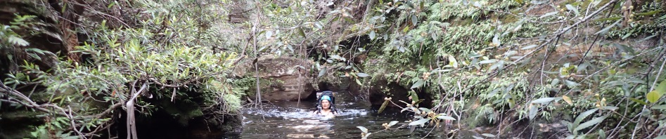
Then came a couple of long swims, we debated whether or not to put wetsuits on but the swims didn’t look that long, and we just couldn’t be bothered.

Anna and Rod in one of the swims.

We passed a side creek with a 6 or 7m waterfall, didn’t look like there was much canyon above it, but as our camp site was a mere 50m downstream, we decided to go back and check it out.

Our campsite. Not the best overhang in the world but enough to shelter us if the predicted rain became a reality.
We were all in bed by 8pm, totally stuffed after the day’s walking/canyoning. We got up next morning and reassessed the situation. None of us were keen to pack up camp and go downstream 2k to the next overhang (that we knew about). This would mean adding a further 3k of walking down stream (through log jams) and a further 3k to our walk out and after the hot walk in we weren’t keen to do either. There was an exit route 20m upstream from the camp cave, so we decided that we would make the overhang a base camp and explore the canyon we’d passed the day before, and then if we had time, go downstream looking for a better camp cave, and other possible canyons. So, leaving Rod in camp, Ed, Jo, Anna and I set off up a very convenient ramp adjacent to the side creek we’d explore.

Another really hot day for an up-hill trudge but at least we were travelling light with just ropes and emergency gear “just in case”. The ramp was brilliant, straight up through two cliff lines.

The vegetation was very friendly so no bush-bashing at all.

We even came across some long stretches of exposed rock when we were traversing along the creek looking for a way down – not too early that we’d miss out on “canyon” but not too late that we’d be bush bashing down in the creek. Plus, we had to make sure that whatever route down we took, we could reverse it, just in case.

We had to go further than expected but eventually found a good ramp down into the creek.

This wasn’t looking promising at all, lots of scrub, with no water to speak of (photo: Ed S)

It was a toss up whether it was easier at the side or in the creek, none of it was good.

Eventually we came to a small drop, easy enough to get down, and Ed checked out whether or not we could reverse out … if we came to a drop longer than the ropes we had, we would have to reverse our way out.
This drop down was followed by another small 8m drop so we set up the 20m rope to get down safely, we then sent Jo ahead to suss out the next drop. She reported back that there was another large drop into a pool without an anchor we could use, followed by what looked like a smaller drop into Dumbano Creek.
I figured that our 20m rope would do for the last drop and the 40m rope would do for the first 8m drop and the second one into a pool (where there wasn’t an anchor), so we re-rigged the 40 and as luck would happen the 40 reached down to the pool. Worse case scenario, we would have just abseiled on the single 40 and walked upstream to get the other 40 from our campsite and then re-rigged as a double 40 (will make no sense to those who don’t canyon) but it was a good solution.

Ed abseiling down to the pool, was a very slippery waterfall.

Jo abseiling down

Ed at the end of the pool next to a good tree that we could anchor off.

Jo abseiling down the last drop, using the 20m rope.

Ed abseiling down – Anna had given us directions not to damage the lovely bank of moss off to the left. There were lots of tree roots hanging down the small watercourse – probably from the tree we’d anchored off!

Walking back upstream to our campsite.
Jo decided to spend the rest of the day in camp with Rod (so we gave her instructions to gather firewood to put in a sheltered spot with the expectation of rain that night). Ed, Anna and I then headed downstream to look for (maybe) a better camp cave and any likely canyons in the side creeks.

Shortly after leaving camp we came to a massive boulder choke that we had to negotiate around.

Ed checking out whether this branch would be good enough for us to climb up to avoid a compulsory swim – we opted for the swim, but climbed down here on the way back.

Further downstream a convenient log to avoid the mass of flood debris.

We mainly kept in the creek, clambering over logs and sticks which would trip us up … every time we saw an overhang we’d go check it out.

We came to one side creek and the closest we got to a canyon in it was the entry … checked out what was upstream but it was open and scrubby.

At our “turn around point”, we tried to explore up this small creek, Ed, that you can barely see (the yellow helmet on the left), tried to get up this small waterfall but was thwarted. We did find a good exit route west of it up through the cliff lines though so thought that if we ever came back we could easily get up to see what was upstream.

Heading back upstream we checked out another side creek on the southern bank. This one was more promising, a couple of climb-ups to negotiate.

And scramble down. It’s a medium sized side creek, may hold something worthwhile.

Our return to the camp was much quicker than our trip downstream, for one thing we weren’t looking for camp caves any more, and we stayed up out of the creek, hugging the cliff-face where possible and taking advantage of some nice easy ledges.
We were back at camp by around 4pm and settled in for dinner. It rained a little overnight but our overhang protected us and it can’t have rained that much because the fire was still smouldering next morning. We reassessed the situation and decided that there wasn’t much point going further downstream on this trip and should probably take advantage of the easy exit route 20m upstream from our campsite. So, we packed up with the intention of heading out before it got too hot. We were a bit slow and eventually left camp at 8.30am.

Our camp site (overhang) for the 2 nights.

The exit proved scrubbier than expected, but after about 20m of elevation, it cleared up a bit and was a really easy route up to the ridge that was our route out. Jo (and map) was going to practice her navigation on the way out.

Anna at the top of our spur at one of the high points, in the distance is the spur we walked in on to access Tunnel Canyon.

The walk out was uneventful, apart from being very hot and humid and then the sun came out, draining our energy. We had many, many stops. Jo did a great job of navigating us out of the wilderness, we didn’t have any unintentional route adjustments!

The tea-tree was a mass of flowers, plus heaps of flannel flowers along the route.
We were back at the cars at 1.15pm (we stopped for half an hour for lunch on the exit ridge), so it’s a 4.5 hour walk in to the camp cave from the NPWS barrier (which is good to know), we did however take a lot of breaks so this could be cut by an hour or so.
The trip was an overwhelming success, and we’ve all determined that we want to go back again in 12 months time. I’m hoping I’m fit enough to do it then, maybe if I don’t carry a wetsuit and cooking stove that might cut off a k of weight!
Thank you so much for putting the trip on Rod, and thanks to Jo and Ed (our trusty rope carriers), without you guys, Anna and I wouldn’t have been able to do the trip!
Yeh I encountered lots of debris yesterday. I think its from last Feb rains. Makes it hard work! Would love to do the tunnel canyon (hint)
Yes, hate that flood debris and logs in canyons! If I don’t do it again, will give you details of how to do it. Could be done as a day trip (very long day though!)
M
So glad the weather improved for you guys from the freezing drizzle of Boxing Day! Though cooler would have been better for the loads you were carrying… I’m with Trish, Tunnel Canyon has just gone on to my list too.
Yes, delaying a day was well worth it. Yes, pity it’s a 4hr walk to the canyon!
That looked like a strong ordeal
Definitely not for the faint-hearted Eric!
looks good great long section, possible to do tunnel in a day ?
It would be a very, very long day, do-able for those who are fit and fast, the combo apparently is down Tunnel and up Cesspit, but that was a group who were extremely experienced, fit and fast. You would want long daylight hours, and not a super hot day.
This is a very well written adventure. Thanks. It is hard to take so many good photos and you nailed that also.
Thanks Peter, really appreciate your comments! The photos are hit and miss though, I usually take about 200 and only 10% are any good!