 SPRING CREEK – Kings Tableland – May 13 & 14, 2017
You know you’re an optimist when someone says “nah nothing there” and still you go looking for a canyon! Following on from the great abseil trip down Blue Drum Creek on Kings Tableland, I got to thinking “there’s got to be some other multi pitch abseils in the area” (apart from Waterfall/Camp Cave Creek).
I contacted some of my network for any hints, specifically looking at Spring Creek and Reedy Creek. Undaunted by some “nah nothing there” comments I organised an exploratory trip for this weekend with Steve R and Trish M … they’ll go just about anywhere with me, trusting souls that they are!
One person (thank you Geoff F) forwarded me a trip report from 2012 which indicated that Spring Creek has a drop in it before the waterfall … “noted approx. 584 556 start of canyon”1, that in itself sounded promising. I knew from the outset that if it was any good, surely someone would have explored the area, but then again, back in the 90s and early 2000s, canyoning was in its infancy and there were so many other places to explore that maybe this area had been overlooked by everyone as there was more “low hanging fruit” to harvest with canyons easier to get to … that’s me, always hopeful.
So, the plan was, walk out on the Lions Head Track, and drop down into a little side creek to the east of the track (and Lions Head 4) and check that out. Then, at the end of that creek (“this ended in a substantial waterfall” 1), climb out the eastern side and see if there’s a ledge at the end of the waterfall in Spring Creek that we could get to. Apparently Spring Creek, is in a “semi circular arc of sandstone cliff … at least 200m high and stretching for some 500m” 2. So, we wanted to determine, if, after the start of the canyon, there was any way to exit out of the creek before you got to what might be a 200m drop.
We set off from the car at 9.30 after a wonderful 2nd breakfast at 2773 in Glenbrook and walked out on the Lions Head track.

The track skirts around the upper reaches of a tributary of Spring Creek and then pops out on a pagoda overlooking the Kedumba Valley, on this occasion filled with fog!

Definitely a photo op at this spot.

The track is really well formed, but still someone felt the need to “edge” the route with stones (you can see the track in the middle)

We’re about 15 minutes from the car, and someone has put a nice chair so you can enjoy the view, fairly new, not bolted down, wonder what would happen in a really strong wind!

Another photo op!

A little further on, another spot on the track to enjoy the view, here we’re looking at Mt Solitary.

Trish fooling around on a small climb down. From here we went to the cairn above Lions Head Pass to show Trish and Steve the pass and then backtracked to the head of our minor creek. On the topo map, this creek is only about 750m long and the last 300m shows it being quite constricted.

The walking in the creek was really easy, hardly any scrub.

We’re in the last 300m now and the walls of the canyon start closing in a little.

A really pretty section of the creek.

The creek was actually quite pretty, but the constricted sections kept opening out, so whilst occasionally it was canyon-like, it was more a nice creek.

Cliff sides closing in a little.

One of two or three waterfalls that we could walk around.

Another canyon-like section – I got really excited thinking it would continue, but it didn’t!

It opened out again!

Looking back up the creek.

Finally we’re at the end and looking out into the Kedumba Valley, and the Kedumba Walls (heading off into the distance – in all about 30k of these cliffs). We can hear the waterfall at Spring Creek but can’t see it!

“Nah” says Steve, “no way is this drop to the valley floor any more than 40m”!

We head up the eastern side of the creek, way back from the edge (I’d been having feelings of mortality all morning), this was a bit of a scramble, Steve set up a handline for me to grab onto.

Our lunch spot with a view, Spring Creek waterfall is directly below and to the left of us we can hear the waterfall cascading over the cliff but still can’t see it.

We stayed as low on the nose of the spur as we could, trying not to lose any height and pushing through vegetation.

Finally we’re at a point where we can see the end of Spring Creek going over the cliff, there seems to be a pool right at the end. We could hear water falling below us and see that there was a canyon-like section upstream but we couldn’t get close enough to see it from above.
We skirted around to the east for about 100m and finally were able to make our way down into the creek. There was quite a bit of water.

We started walking downstream and immediately came to a pool of water that we would have to wade through – none of us wanted to get wet, you can see ahead though that there’s rock-face on either side of the creek.

So we headed upstream to see if there were any waterfalls.

Nice section of overhang

Nice pools

And finally after 200m in the creek the end of the line for us, a large pool, with no way around without climbing up high and we were over the scrub in the creek by this stage. Looking at the map, it was obvious where we were and from the track notes I had, there wasn’t anything upstream that would be an abseil, the abseil(s) was downstream of where we’d entered the creek.

So, we headed up, this was a tricky climb, I haven’t seen anyone use the buckle of a boot before as a hand hold!

The walk out was a little steep and scrubby, basically up a bit of a gully.

And when we got to the top, it looked like we’d have a good run back to the track, flat plateau, due north to the Lions Head Track.

Unfortunately, our “good run” didn’t last very long and we had the most horrific scrub to push through, banksia and tea-tree and all manner of stuff to stop you. There was no let up, basically 750m of the scrub from hell (only positive thing is it wasn’t hakea!) and no landforms to navigate by, all compass bearing.
We tried to skirt around some of it, but there was no relief so just had to deal with it as best we could. Eventually, I knew we were close to the track and so just headed west to it. We reached the track, shook ourselves off and made a bee-line for the car. What had we learned …
- The little creek to the east of Lions Head Track, whilst nice, isn’t worthy of taking ropes and abseil gear for only 1 abseil, and 40m at best.
- Spring Creek in the summer might be ok but the banks were too scrubby and the pools too big to consider doing it in the winter.
- If the scrub around the upper reaches of Spring Creek is anything like the scrub on the plateau, we weren’t going there, so the only way in that’s half-way decent is via our little creek to the east of Lions Head Track. And, the quickest route for that is to go to the saddle immediately before Lions Head and drop 200m into the creek.
- There’s no way to go past the part of Spring Creek which needs a rope and not abseil the waterfall (unless you want to reverse the abseil by prussicing out and who wants to do that!).
So, the only way that you could abseil Spring Creek is if the abseil was less than 60m (cause there’s not many abseilers who’d consider carrying 2 ropes longer than 60m for a couple of hours just to do one abseil!).

We camped just off Kings Tableland Road, nice and flat and plenty of firewood.
Around the campfire, we reassessed the situation and decided that if it was raining in the morning we’d go back to 2773 for a nice breakfast (reward for me dragging them through that horrific scrub), but if it wasn’t raining, then we’d go out to Lions Head Pass and drop down to the base of the cliff line and traverse around to get a look at Spring Creek waterfall from the bottom and determine just how high it was, and if there was the possibility of a multi pitch decent … “close up the falls are not so spectacular, they comprise a number of small falls, dropping short distances and separated by areas of rock”3.

Whilst we’d had drops of rain overnight, the weather looked ok so we set off again. What a difference a day makes eh, yesterday blue skies and fog, and then the next day, low cloud.

Not much of a view from the chair!

We headed out to Lions Head Pass and dropped down, then skirted around the base of the cliff, there wasn’t much scrub, but the terrain was very steep.

We gave ourselves 3 hours, if in 1.5 hours we weren’t at the waterfall, we’d head back (after all 2773 was calling)

At times there looked to be a footpad but it was probably only an animal pad.

We thought we’d rounded the base of Lions Head, but couldn’t hear the waterfall, so knew we were still a good distance from it. We reassessed the situation and it was close to our 1.5 hour turnaround point so turned around. In actual fact we still hadn’t rounded the point, and we were still about 400m from the waterfall (maybe another 45 min).
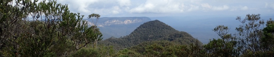
We were up at the top of the Pass with time to spare so thought we’d head over to Lions Head and see if the waterfall could be viewed from there. We walked about 300m and could see Lions Head in front of us, boy that’s a big hill (the hill in the banner up above). We were pretty stuffed and so decided that we’d save Lions Head for another day.

Note, the creek on the map is slightly “off”, we were always on the northern bank of the creek though our track is shown on the southern bank.
We were back at the car by 3pm and headed off to Glenbrook. 2773 was full of people (Mother’s Day), so we ended up somewhere else!
So, I’m not giving up, I still think that this is a possibility, so I’m heading back either with my camera or with DS and his drone (when he’s mastered it because I don’t want to go down into the valley looking for a drone that’s crashed!). The route in to Spring Creek that I’d take is damned easy, an hour on track, then drop down into the small creek and up the other side, an hour at most. The abseils are the big question (which is why we need the drone), but after that, it’s probably a 2 hour walk at the base of the cliff to Lions Head pass, 1/2 hour up the pass and an hour back to the car – sounds do-able, right?
1 August 1992 – Graeme Holbeach (Sutherland Bushwalking Club) trip notes
2 & 3 May 2012 – Michael Keats (The Bush Club) trip notes
4 On the Topo Map, Lions Head is actually mis-placed (between a small unnamed creek and Spring Creek). It’s actually right on the cliff-line before the cliff heads east over to Spring Creek. So, the one shown on the map is now referred to as False Lions Head.
Another good report Marilyn. I really like the photos the description is also very well done. I am not fit enough to do a long walk like this but could be persuaded to go on something simpler.
Will keep that in mind Roy, could take you there and you could just walk to where you’re comfortable and wait for me to return (with pics)! watch this space.
Looks like you all had a great weekend, I’m quite enjoying this armchair adventuring keep up the hard work Ill keep an eye on my emails for the next adventure!
Yes, that armchair adventuring seems to suit you!