 BOOLIJAH CREEK, ETTREMA WILDERNESS – 11 – 12 March, 2017
Well, if you’re me, you can! Dressed in short sleeved t-shirt and shorts, I was joined by the “cover every square inch of skin” group (aka the “smart ones”), Melinda T, Steve D, Steve R and Jeff B.
For the last four or five years, Melinda and I had unsuccessfully tried to do a trip together; finally last September we both committed to a date in six months time (yes, we’re both into planning ahead). Melinda lives down on the South Coast and does a lot of walks in that area, and Geoffrey J’s map (that I had used in the past for a walk to Discovery Cave) had a nice little route on it into Boolijah Creek with the promise of some waterfalls – neither Melinda or I had done that walk.
On the map, it looked like a bit of a bludge trip, most people would probably do the whole circuit as a day trip but I was sure we’d find some other spots to explore and if we were driving all that way, I couldn’t see the point in not staying out for the night.
There was almost a “blog emergency” when I discovered that I’d left my camera behind (I was going straight from the airport to meet up with Jeff & Steve on Friday afternoon). So, I sent an SOS to Jeff for him to bring his camera.

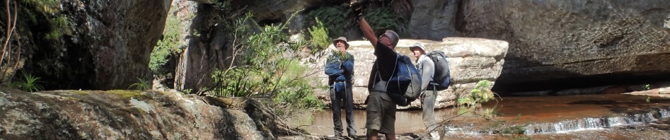
Starting out on the Yarramunmun fire trail. Melinda and I set a cracking pace that the guys could hardly keep up with but after a k or so, we slackened off and let them overtake us (lol).

Then we set off into the bush, which was fine until we got to a band of hakea.
 Now, this image to the right might not be the actual hakea that we were in but you get the idea, the leaves are needles about 5cm long with a very sharp tip, and where we were, all the sharp bits were around arm height, how could I have forgotten about it?
Fortunately on the route in, there was only a small band of the Hakea, then we got into the sword grass, equally as lethal but I was prepared for that with scrub gloves.
It took us half an hour or so for us to get to our first objective … check out a couple of camp caves. Geoffrey had said that they were only big enough for one or two, and whilst the 2nd one was very small, the first one we came across would sleep the five of us and the creek just below it was running with fresh water, camp caves don’t get much better than that. So, we dropped packs, loaded up our day packs and set off to explore.

We climbed up at the side of the camp cave and accessed the cliff-line, with the idea to walk around and find the pass down into the creek. Great views!

There were also some interesting “slots” where the rock had come away from the cliff-face, and this small rock that looked as though you could push it over the edge (which Dolphin tried to do)

The pass down through the cliff-line was relatively easy with only a few spots to try the vertically challenged (like me and Melinda)

Before long we were in the creek and making our way downstream to the waterfalls we’d been told about.

The first cascade, we’d only walked a 100m or so and we were all ooh-ing and ahh-ing, very easy walking and one lovely cascade after another

Really pretty sections of the creek – it was at this point that Jeff’s camera ran out of battery power – fortunately Melinda took some really great shots after this. (Photo: Melinda T)

Even the scrubby, overgrown sections were easy – me in amongst the bushes! (Photo: Melinda T)

One beautiful cascade and pool after another (Photo: Melinda T)

The rock was way slippery so you had to be careful crossing (Photo: Melinda T)

Scoping out the way ahead, this waterfall went down and then around a corner to a big pool, everyone else when to the left but I could see a nice route on the rh side – only photo I’ve ever seen of myself where my legs don’t look like tree trunks! Thanks Melinda (Photo: Melinda T)

Our lunch spot with a view – I had a quick swim in the water, it was a little chilly (Photo: Melinda T)

Another lovely pool (Photo: Melinda T)

And another waterfall and pool (Photo: Melinda T)
We then came to a waterfall and pool that we couldn’t get around without going up high on the bank, so we climbed about 30m. When we’d all regrouped we considered our options … the only one who’d brought a head torch was Dolphin (how bad was that, you’d think we were all novices – all up there had to be 115 years of bushwalking experience between the five of us!), so we decided that as it was 2.30pm and we had yet to find the pass back up to the top, we’d better forego any more exploration of the creek and head out. We clambered up to the base of the cliff line and then walked along about 400m until we came to a likely route up, which turned out to be the pass that Geoffrey J had marked on his map. Steve and Dolphin went up first and set up a hand-line for Melinda and me.

The pass, Jeff went back down and retrieved my pack which I’d left behind (long story), it did however give Jeff the chance to do a little “caving” (Photo: Melinda T)

The rest of us at the top of the pass waiting for Jeff to return (Photo: Melinda T)

Popping out at the top of the pass with Boolijah Creek in the background (Photo: Melinda T)

Stupidly, none of us had picked up water back down in the creek (again, you’d think we were novices wouldn’t you), so we took advantage of some water lying around to have a drink. After this, there was about a k of hakea to walk through with the odd rock slab!

We made it back to the camp cave by 4.30pm and set ourselves up for the night, plenty of room. I scored it a 9 out of 10, only deducted one point because it was too close to the fire trail and only room enough for 5, but other than that it was perfect.

Steve relaxing with a cuppa.
We decided that the next day we would head downstream on the creek that the camp cave was on and explore upstream in Boolijah, we had no idea what we would find. I had brought along my iPhone which was charged up so I put it in Airplane mode and used it as my camera, am very happy with the photos, was a pain keeping it dry though and making sure I didn’t drop it!

Jeff led the way down.

It looked decidedly slippery getting over to where he was, but hey, he didn’t slip so the rest of us could do it.

Dolphin making sure Melinda didn’t slip.

We stayed high out of the creek and headed down the spur, it was a very easy route and looked a little worn in places, perhaps others had been down here.

Once in the creek, there were quite a few boulder sections but nothing that we couldn’t handle

We expected the creek to get scrubby as we went upstream, but so far it was really nice

Steve giving Melinda a hand up onto a high boulder.

Dolphin in his element, out the front route finding and checking out the cliffs.

Our overall impression in the creek was one of green-ness, mossy rocks everywhere, but not the slippery kind, the ferny kind that you could walk on and not slip

And we still haven’t come across scrub! And where were the fallen trees and logs that are the curse of creek walking?

We were gaining a lot of elevation, although in small increments

This looked like a campsite from the distance but turned out to be just a large rock covered in leaf litter, we had morning tea here.

I seem to remember that this was the only log we had to climb over (or under)

Really pretty section of creek and Dolphin and Jeff solving the problems of the world.
It was somewhere around here that Jeff and Steve spied a “pinnacle” and thought it would be a good idea to climb it to see what was ahead of us. The creek seemed to be opening out and we thought that we had gone past the cliff-line and maybe the creek would now open out and just get scrubby. So, we decided to climb the pinnacle (even though it was on the wrong side of the creek – the opposite side to where we’d exit from) to see what was up ahead. So, up we went.

It was pretty easy going until we got to this small climb up – there were lots of loose rocks and sticks, so we each had to go up while the others stayed out of the fall zone.

Melinda almost at the top

Finally up on top of the pinnacle and it turned out that there was a little more cliff-line upstream, although not all that much, maybe 100m or so

Jeff and Steve deciding where our exit point would be – unfortunately they asked me (somehow I’d become the “leader”) and I said that we should go further upstream as there was a really good, negotiable exit creek on the map around the corner of the cliff-line you could see in the background. Turned out to be a good decision.

Melinda had looked around for another exit off the pinnacle without success, so we had to return down that dodgy climb-down, Melinda waiting for her turn to go back down.

Steve making his way down, that big log in the foreground had to be moved a bit so it was more stable.

Melinda at the top ready to come down the mossy part.

Once down the bottom, just around the corner, Jeff found an “Aboriginal Sacred Site”, he told some lame story about male children and animals feeding them. It must have been some Sydney Bushwalkers “thing” because Melinda and Dolphin picked up on it and knew what he was talking about … sounded like a load of crap to me.

Back down into the creek and another pretty section with a large pool

On both sides of the creek at this point were large ledges covered in moss, you could easily set up camp here.

We were now about 200m beyond the Pinnacle and we came up to this cascade, it was definitely a “wow” moment, a large expanse of water gently falling over this small ledge (Photo: Melinda T)

“Wow”, standing on the ledge, looking upstream. We couldn’t quite see what was ahead, so I suggested if I didn’t get wet past my knees that we should all go forward. It was ok until the second rock and then it got very deep (chest deep for me). But, Steve and Dolphin decided that it was worth getting wet to see what was up ahead.

And it was worth it, another Wow moment! The end of the line, a very large, deep pool with a 10m high waterfall at the end and from where we were standing, there didn’t look to be any way up. In hindsight I probably should have swum up to the end to see what was there but the water was cold and it was probably close to a 50m swim!

And coming in from the rh side was a waterfall, about 30m high, not a great flow of water, but still substantial. I was so pleased that we’d come as far as we could go!

Steve at the end of our journey up the creek.
We retraced our route through the pool and then climbed out of the creek up a very convenient set of stairs (that Melinda and Jeff had scoped out), and got up above the cliff-line. I spotted a cleared section so made my way over to see if we could see down into Boolijah and see what was above the waterfall, you couldn’t see upstream of Booljah but you could see upstream of the side creek’s waterfall.

On the cliff-top above our pool and looking across at the waterfall … The side creek looks easy to walk in, quite open and big flat slabs of rock, makes me think that the top of Boolijah may be like the side creek above the waterfall … possibly another trip?

Coming off the cliff-top we found this birds nest, not sure what kind of bird, too small for an emu!

The group on the cliff-line above the waterfall, checking out the views.
From there it was a 750m trek through hakea and banksia, although it seemed like 5k, by now we’re all over hakea! There were a few rock slabs to walk on but in the main it was scrub. Having said that, all up we would have walked through maybe 2k of scrub on the plateau, of which only 50% was hakea, not that bad, all things considered!
The Stats are in (thank you Jeff) …
Total “moving time” 5hrs 19min
Average “moving speed” 3k/hr
Distance covered – 16.05k
We started at 9am and finished the next day at 1pm, so for the balance of the roughly 27+hrs, we were sitting around the campfire drinking tequila and red wine (and of course sleeping!). Sounds like a bludge weekend, but I’m a bit stiff today and have scratches on my scratches!
A great trip with Melinda and Dolphin, and of course Jeff and Steve, and thanks so much to our Ettrema guru Geoffrey J!
Thank you for inviting me along on this amazing trip, Marilyn. A real adventure in a rarely traveled area. Certainly tested my skills, loved it!!! Let’s not wait 4 years for the next one 🙂
Thanks Melinda, it was a pleasure having you along on the trip!
Good old Ettrema, the Hakia is always there to greet you.. what a beautiful area especially the first day with all the beautiful waterfalls and cascades, you all take great photos which makes it feel like we are there with you.
And well done with the weather Marilyn
True story that sacred site I heard that from our local Darkndrunken tribe!
Yes, picked the one weekend out of six that it hasn’t rained!
What about the pack story??? You can’t leave us not knowing how you got separated from it!
On the way up, I saw that you could possible go through a small cave, so I threw my pack across to the other side, then decided that the squeeze was too small and my pack then was out of reach, so I left it there thinking that one of the guys could take it to the top for me. But no-one picked it up so Jeff went back down and got it for me. Turns out I’m bigger than I thought I was!