 CANYONING – NEWNES VALLEY – Log Slide – 19 February 2017
After our Big Day in Looking Glass, we were hoping for a much easier day. John was being very mysterious about the canyon for the day. Apparently, years ago, around the date of his birthday John would put on a mystery canyon where you knew nothing about the day (not even the name or whether or not to bring a wetsuit). So, we didn’t have a clue what to expect.
Beth and Andre decided that (in the interests of looking after Beth’s dodgy ankle that she’d jarred in Looking Glass), they’d take the day off and catch a bacon & egg McMuffin on the way home. The rest of us set off up the pass behind the camp ground, leaving Cat’s husband Garth in charge of packing up their camp.
Over the course of the next hour or two, John gave us the low-down. Apparently, this canyon is listed in the Michael Keats encyclopaedia of bushwalks and place names, so, whilst it’s not well known, it has been “published” so to speak.

Climbing up the steep pass, even though we started early and there was cloud cover it was still hot.

Cool strangler vine climbing up a tree

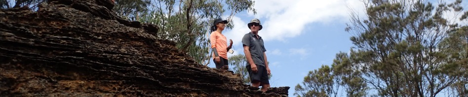
High point at the top of the pass, not very good views of the campsite down below, but magnificent views out into the Capertee Valley

Easy walking at the top down into our creek system

Lots of tree ferns and thankfully some shade

I couldn’t resist this shot looking up into the tree ferns, I’ve seen better shots than this, will have to work on my technique

Walking down towards our creek, looks like no-one has been here for a long time!

The pagodas are getting closer and closer although the creek valley is still pretty wide.

Eventually the creek closed in and we came to our one and only abseil, but it was a beauty, something for everyone, very squeezy, wet under foot and lots of slime! My rope was orange by the time we’d finished.

Cat on the abseil, there wasn’t an anchor in place, and we didn’t leave one behind, it’s really cool to visit a canyon with no man-made anchors and it’s so “out of the way” that there’s no need for them to be placed.

Me on the abseil, it was so slippery that you couldn’t place your feet in the slime. (Photo: John G)

The bottom of the abseil, it has a large double Coachwood in the middle of it.

This huge rock has fallen off the cliff above, it was resting on a large rock.

Walking downstream, very few large trees to be seen


Back in the creek bed, again, no large trees, a lot of saplings and heaps of tree ferns.

The creek closing in again and a couple of down-climbs

Cat on the down-climb into the creek

At the start of the log slide
Although I’ve been told that Newcastle Bushwalking Club visited the creek circa 1970, and there was another visit by someone else in the 1990s, I’m sure there have been heaps of visitors over the years since this infrastructure was placed (possibly in the early 1900s), but those that have visited since then, didn’t think that the creek itself (or the canyon) was worthy of naming.
So, what’s behind the name Log Slide? According to Michael Keats, he named the “canyon” because of the hand chiselled square holes that are positioned at 1m intervals (I think some were way more apart than 1m), forming a constant slope down the canyon. He says that in places you could see several examples of cross beams wired to each other forming support trusses for the deck of the slide. I didn’t see any of these trusses in the canyon.
We’ve all surmised that in the 1900s, upstream of the lower section of the canyon, there must have been a good stand of Coachwood trees. They’re not there now, there are some, but certainly not as many as would have been there in the 1900s. They would have logged as far up as the waterfall abseil, dragged the logs down to the start of the canyon where John is standing in the photo below, and then slid them down over the horizontal logs.

John at the start of the log slide, with Jo, Cat and Tim sitting/standing on the logs remaining.

Not all logs had nice square notches, sometimes they were rectangular, but there are certainly a lot of them.

These logs are towards the end, further apart than 1m and they rested on the ground on the other side of the canyon. (Photo: John G)

At the end of the canyon, there is a big cliff-face that extends around to the right, very impressive (Photo: John G)

We made our way down/along the creek, eventually coming to a small down-climb that was really awkward, after the down-climb we found evidence of a bullock track, 2m or so, carved into the side of the slope.
We were able to stay on the bullock track for a while, then lost it and it was just a slippery slope down to the junction of the creek where we picked up a very old fire trail which led back to the Wolgan River.
We were back at the cars by 2pm (or thereabouts) a nice 5.5hr trip, we then had custard cake (courtesy of Garth & Cat), Tim Tams (thanks Jo) and more Ice Creams (courtesy of John), it doesn’t get much better than that does it!

We needed proof of the ice creams – Jo with a cone and Tim finishing off the melted ice cream in the container!

And Tim said we needed proof that we were at Newnes, hence the background shot! (Photo: Tim G)
John’s Mystery Canyon weekends are usually around his Birthday in February and with the enthusiasm that this one generated, I think he’s putting his thinking cap on even as I write to come up with a good one for next year!
As the saying goes “rust never sleeps” !!!!!!!
My 1 hour walk just doesn’t cut it eh M??
Better a 1 hour walk than nothing! Yep, live every moment, the time when I can’t do this stuff will come too soon.