 Canyoning – Newnes Plateau 15 & 16 October 2016
I did say that we’d be doing exploratory canyons and not to expect too much, maybe there’d be some constricted canyon, maybe not. They were after all unpublished canyons and if they were any good they’d be in the Guide! Am pretty sure though that the weekend’s canyoning exceeded all expectations, PLUS I gave Rod the opportunity to gloat!
This was a combined MSS & BWOC trip but as it turned out, everyone was a member of MSS. We were doing “Evil Kenievel” and “Lone Pine Canyons” (my nicknames for them) on the Newnes Plateau. We camped out near the Alcatraz exit which was really nice, no other campers there, and no traffic. Rod S, Trish N, Nick & Marcella P and Jo and Ed S joined me for the weekend, here are some photos …

After a short walk through less than friendly scrub we arrived at the creek, so far looking pretty good. The waratahs were out giving a great display.

We then got into some scrub and had to cross the creek, this was our first indication that the water was freezing, it was hard to get up the other side so Rod lent a helping hand.

We knew there were some swims ahead, so suited up, even though it was hot, we’d need the wetsuits in the freezing water. We all had a difficult climb down here but Trish found the easy route!

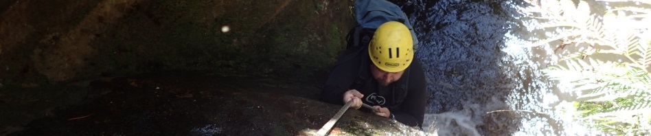
Nick in the foreground, then Marcella, Ed and Rod, in the creek

Compulsory swim after the first hand over hand on a slippery slope

Rod at the hand over hand, it wasn’t easy, I kept on slipping

Marcella on the first water slide, there was a small pool at the bottom

Nick on the second slide, another small pool, most of us walked around this one

Marcella on the one and only abseil, probably about 3 – 4m, followed by a compulsory swim

A small climb down and another compulsory swim, by this time we were over the cold water and had no feeling in our feet, what were we thinking doing a wet canyon so early in the season?

Nick negotiating a small climb down, this was followed by another compulsory swim

Another slide if you wanted to do it, or you could easily get down on the left, there was a pool to the right to land in.

Ed chose to do the slide

After the slide came a lovely cascade which we were able to negotiate our way around, this was followed by a small deep pool but Trish, Jo and I found a way around it.

After lunch, some of us went to do River Caves, was interesting going down the canyon (creek) – most people go up the creek.

You can actually negotiate your way around this swim but I didn’t realise it until I got through and on the other side.

Trish and Ed trying not to do the swim!
We were back at the cars by 3pm. Ed and Nick were a little concerned about the rocky hill we had to drive up to get back to Northern Boundary Road, but their little cars made it without any problems. We then made our way over to the old Forestry Camp area, near the Alcatraz exit trail, I’d promised a nice grassy campsite but that must have been in my imagination, I could have sworn there was one there! Where we camped was flat, and there was plenty of fire wood and we didn’t have to share it with anyone or have cars driving past, so, it wasn’t all that bad, I’d definitely go back there again!

Ed brought along his slackline and the “youngsters”, Jo, Nick and Marcella had a go. Ed eventually mastered the sideways shuffle

Nick giving Marcella a helping hand

Jo perfecting her technique

Nick was the acknowledged champion racking up an impressive 7 steps to the middle before his dismount!

A full moon around the campfire, thanks Nick for setting up this shot for me.
Nick and Marcella had to leave us on Sunday for their big drive back to Narrabri, brilliant effort them driving down for just one day. We left Ed’s little car at our exit point and drove the two other cars around to the fire trail which would give us access to the creek we wanted to explore. Having done the first part of the canyon before, Trish and I had no trouble getting down into the creek, and as it was almost a “no brainer” I hadn’t brought along my map or gps, how hard could it be, I knew exactly where I was going!
Anyway, we made it into the creek and soon came to our one (and only) abseil, about 15m down into a very constricted part of the creek. Once down we were able to walk up about 5m to see the waterfall that we’d missed because there wasn’t a convenient anchor. All up there was about 20m of constricted creek (canyon), and then that was it.

I sent Rod over first (our crash test dummy), he cleared a bit of the scrub for us.

Jo on the abseil

My camera couldn’t capture the little waterfall we abseiled down beside, so will have to go back there to photograph it (and do the abseil). Shortly after the constriction, we walked down about 50m and were at a junction, there was a big “hole” that we went up to explore to see if we could get another abseil out of it, not worth the effort.
At the bottom of the creek, and the junction, I “thought” I was 200m upstream of our exit point. While the others were having morning tea, Trish and I went off to explore a bit, they sat around with Ed’s map and compass and determined that we were in fact right at our exit point. When Trish and I returned, Rod was adamant, and I was equally adamant that we had 200m to go (“just humour me Rod!”). Last time I ever leave my GPS back in the car. So, we headed off downstream (Rod humouring me), and then at the next junction, sat down for lunch and reassessed the situation. Yes, Rod was right – simple error of me thinking I’d entered the creek 100m further upstream than we did. Plenty of gloating by Rod – and embarrassment on my part!

A convenient log to walk downstream and the scene of the mutiny, with Rod and Ed convinced that we were at our “exit point” and me adamant that we had 200m to go!
Once we’d all agreed that we were in fact 200m downstream of the true exit point (and a guaranteed track), we decided to just head up and “hope for the best” to find an exit route out rather than go back upstream 200m (through scrub). So, we scrambled up to the first cliff line (this part was easy). Rod went to the right and Jo, Ed and I went around to the left. Rod got cliffed-out but after 100m or so, Jo, Ed and I came to a gully that looked like it would “go”. So, we all regrouped and headed up the gully, which ended in a number of pagodas. Rod did some excellent rock climbing and got up the top, setting up a hand-line that the rest of us used to climb up in a less exposed spot.

Trish at the top of our 10m climb up.
Once up the top, it we discovered that we were 100m from our planned exit route, so the shortcut we took was worth it.
From there it was a simple matter of finding the track back to the car (easy), and then Ed, Rod and me retrieving the other cars from the other side of the valley. We regrouped and were ready to hit the road by 3pm.
It was a great weekend and I definitely ticked one canyon off my wish list (not sure I’d do it again though), and pending confirmation may have ticked another one off (will go back and do it again, just to do it the “right way” and also abseil down the little waterfall, a nice 2 stage 15m abseil). Thanks Nick, Marcella, Jo, Ed, Rod and Trish for joining me.
Can’t believe you did a canyon with so many swims so early in the season! You are so brave. How come you didn’t do the slides? I have never known you to say no before! R U OK?
Yes, was a little cold, and that was the reason I didn’t do the slides, didn’t want to get wetter!
Pingback: M***m canyon – a little gem | Adventures with M