 SHOALHAVEN OVERNIGHT WALK – APRIL 2013
Badgery’s Spur > Shoalhaven River > Secret Campsite #5 > McCullums Selection > Long Point Tourist Track > Long Point Lookout
This was to be a beginners walk, and really everyone was having a ball until it went hideously wrong, all because the track on the topo map is in the wrong place.
At least that’s my story and I’m sticking with it. Mind you, although I’d walked the Long Point Tourist Track two or three times, it had been many years since I’d done it and on those occasions I wasn’t leading the walk so didn’t really pay attention to where we went.

The Group (top row l-r) Steve, Katrina, Trish, Theo, me (bottom row l-r) Sandi, Hayley Tom – the morning of Day 2 and all happy & smiling before it went downhill
So, eight trusting souls met up with me at Badgery’s Spur and we walked down to the river, we walked upstream during the rest of the day and eventually stopped at my secret favourite campsite and set up camp. It was fabulous, lots of room, lovely grassy bank and the river with some rapids just beside the camp.

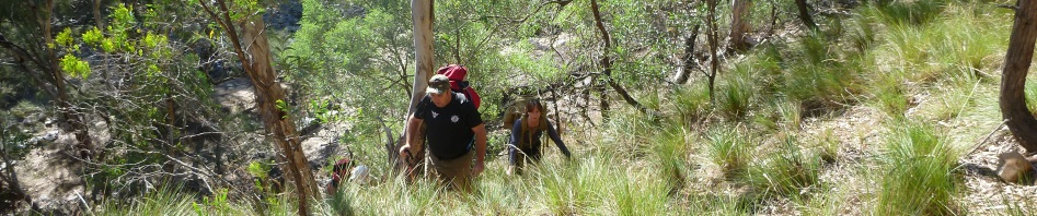
Day 2 – a lovely grassy section, Sandi and Steve
The group was having a ball, yes, it was tiring walking up stream but once they were at the camp and frolicking in the river they were in 7th heaven. Then we had a nice fire, enjoyed a chat around the campfire over dinner and eventually hit the sack. The weather was perfect, all was well with the world.

Jo crossing the river

Walking on the river bank, just downstream of McCullum’s selection
Next morning we started on our way out. We had to climb a small rise to avoid getting wet feet, well, the water was deep so it might have been more than feet that got wet. Past that obstacle we were back on the river bank and mosied along. We took our time (after all we had all day to walk a very short way) and soon were at the river crossing to get over to McCullum’s Selection. Across the river (the group was used to river crossings now) and we made our way upstream to have lunch by the river and have a swim.
I determined that at 1pm we’d leave the river to go up the Tourist Track, it was only a 90 minute walk up, we’d be home early. So at 1pm we set off up, climbing up a small rise to the flat area where McCullum’s Selection was. I had my topo map and my GPS with the map on it and at the bottom of a spur the GPS showed that we should be right on the track. Now, it had been a long time since I’d last walked that tourist track (I’m thinking 3 – 4 years), so I couldn’t remember whether or not it was a well-beaten track or just a footpad. Anyway, we started up the spur where I thought the track should be, not seeing any track, but it was a very wide spur and I figured that others had just spread out and wandered up and when the spur narrowed then the track would become obvious.
I asked everyone to spread out across the spur to see if they could spot it, and had my two most experienced people up in front, they’d pick it up sooner than anyone else. So, we walked up, and up, and up. No sign of a track, the GPS showed me that we were right on top of it, where was it? Amazingly, an hour had gone by, it was very steep, we were all tired and we still weren’t on the track. By now I’m thinking we might be in trouble, I didn’t really want to go back down, after all, there was no guarantee that there was another track down there, plus, I knew that there was a negotiable route up and over King Pin Mountain (and the map showed it), and I figured we must be on that, there should have been a track off to the left (the tourist track) but there wasn’t, so, we’d just have to make the best of a bad situation.
This would have been all right with a group of experienced walkers but with 6 beginners with me (one of whom was on her first overnight walk), it wasn’t going to be pretty.
So, I encouraged them to continue up the spur which by now was a nasty scree slope. No-one was happy, in fact tears were shed! Scree at the best of time (for experienced walkers) is a pain but for these poor people it was horrendous, every step forward, you slid half way back and the little bushes (if you could call them that), easily came out of the ground if you tried to hang on to them. Anyway, they soldiered on and eventually we were all on top of a small rise … at least I was hoping it was the top and breathed a sigh of relief.

Trish M at the top, you can’t see it but she is so proud of herself getting to the top
I took stock of the situation, the person I’d shepherded up was fine, now that she was at the top. I had one person who was deathly afraid of heights, not much I could do about that but I put her off to the side (away from the gaping precipice down to the Shoalhaven), two people had heat exhaustion and one girl’s vision was compromised (she said her eyes were jumping around and she had double vision). Not a very good situation to be in, so, when everyone was rested (and I’d sprayed them all with some water), I organised Theo to take the pack of the (now) “blind” girl, and asked him to go ahead and find a good route. He went off and I pretty much didn’t see him again until near the end.

Steve & Hayley at the top, exhausted, but still smiling
The rest of us started with the “blind” girl walking behind me, holding on to me. Just when I thought we were out of the woods we came to what looked like an unscaleable cliff, mind you it was probably only 4 or 5m but with a “bind” person and someone who was afraid of heights, there was no way I was taking them up there, so we sidled down around the high spot and made our way down and around. By this time it’s getting pretty late, around 4.30, and it was now a full-on off track experience, certainly not what they’d all signed on for! I’m also seriously questioning my leading abilities and determined that it was the last walk I’d ever lead!
Anyway, down and around the high point. We moved forward, very, very slowly with the “blind” person and were now sidling along the side of King Pin Mountain, not much point going up, we’d have to come down on the other side, so just sidle along, at least that’s what I told them. At 5.30 I suggested everyone get out their head torches, we obviously wouldn’t be getting out in daylight. One of the group had moved forward out of sight, so now I had 2 people ahead of me and I couldn’t hear them, or they weren’t answering my calls, things were going from bad to worse!
I left the people behind me slowly making their way forward and moved ahead to find the person I couldn’t see, eventually found him, got him to stop and caught up with him. By this time Theo is calling out (where from I don’t know but at least I could hear him), and the others are slowly making their way towards me. As it happened, where I had stopped was right at the end of the King Pin Mountain spur, AND, we were 5m from the Tourist Track. We made our way down the 5m and there was a f*&^%g super highway!
It was 7pm and I’ve never been so happy to see a track. Theo came down to us (he’d taken the extra pack further along the track) and we re-grouped. It was still about an hour before we got back to the cars, it was very slow going with the “blind” person.
I doubt any of them will walk with me again, although one person determined that she’d come back with me to actually walk the tourist track and see where it came out … I was definitely going to have to do that, I can’t believe that I didn’t find it down the bottom.
AFTERPOST: 2015 – I did a walk down the tourist track with the GPS track log on, came home and downloaded the “tourist track” (yes, a super highway) that I had walked. When overlaid onto the topo map on Ozi Explorer, the track on the map is no-where near the actual track. AND down the bottom where my red track crosses over the dotted track, (about 500m away from where I started walking up what I thought was the track) is a big-ish NPW sign. I would never have seen it from where I started. and my route with GPS (red line)")
Pingback: Gourmet Walk & nailing King Pin Mountain | Adventures with M
It was a great trip and we walked with you again.Thanks M
Yes you did! Katrina was amazing on that walk, having never done an overnight before, she handled it with style!