 NAMADGI MULTI DAY WALK – ANZAC LWE – APRIL 2010
Yaouk > Lone Pine Trail > Mt Murray > Murray Gap > Bimberi Peak > Oldfields Hut > Mt Morgan > Lone Pine Trail > Yaouk
Not sure how we decided to go on this walk, but it seemed like a good idea at the time, but we obviously didn’t check the weather!
Nine of us set off from Orroral Camping Ground where we’d spent a wet Friday night and drove around to Yaouk. We parked the cars at the bottom of the hill and started walking up the long, steep climb on the Lone Pine Fire Trail. On this first day we were going to climb around 1200m in elevation.
 Steve C was the nominal leader for the weekend and doing all the navigation, although truth be told, there were far too many leaders on the trip and not enough Indians. We continued along the trail to where Steve determined that we’d cross over Goodradigbee River and head up onto Mt Murray. The day was cloudy and the rain we had on the previous night continued as occasional light showers. As we climbed, the temperature dropped noticeably with another 300m in elevation and the wind had picked up making it very chilly. We had a quick lunch sheltering behind some granite boulders and soon moved off. Finally we were on the highest point of Murray and walking amongst granite boulders, none of which provided much shelter. Some of the group were becoming particularly cold and wet. We were so uncomfortable that we didn’t take the time to admire the lovely granite outcrops around us ant the visibility on top of Mt Murray was a mere few hundred meters, so a brief acknowledgement that we had bagged the peak was followed by the group keen to drop down to the promised shelter of Murray Gap and camp. There were no definite spurs to follow so Steve set the clearest course on a compass bearing and we quickly dropped down back into the tree line.
 Murray Gap is a tussock grassed saddle between Murray and Bimberi. The best of the sheltered camp sites were already occupied by a group from Canberra but we settled into a sheltered area which on a fine night we would have appreciated, but all we could think of right then were getting the tents up and getting warm. I got up my Olympus tent and thankfully we were dry inside, the rest didn’t have as much success. The rain showers were intermittent and some took the opportunity to cook outside, but it was bloody miserable and we were all in bed without even a thought of socialising.
 Next morning the weather to the east looked promising; to the SW “not pleasant”. Some of the party hadn’t fared well during the night as their tents had leaked and they had wet sleeping bags. When the “not pleasant” (cloud and rain) weather descended upon us the decision was made to cancel the proposed side trip to Mt Bimberi and make a bee-line for Oldfield’s Hut.
  Those already packed started for Oldfield‟s Hut, those with tents still up dived into them. Forty-five minutes later the sky cleared again and blue sky started to appear. “Change of plans, it is Bimberi or the hut!” The party split with some going to Oldfields to dry out and the rest of us planning a day trip up Bimberi.
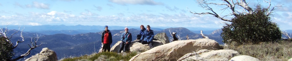
We found a faint foot pad which became more apparent as we ascended. The ascent of approx. 400m was again marked by the change in vegetation. The summit was not a peak but a higher cluster of boulders on a grassed undulating top, an example of high alpine meadows; with occasional clumps of old snow gums to provide shelter in bad weather and granite boulders upright like druid monuments.
The day had turned into a wonderful sunny day so we spent time taking in the 360 degree views. We identified Mt Jagungal; the main range was still in cloud. To the east we spotted the tower on Black Mountain, Canberra, Corin Dam, Mt Namadgi, Mt Burbidge, Mt Kelly… A further highlight was the spotting of a heard of brumbies; at first grazing peacefully and then to be rounded up by the stallion and moved, at a gallop, out of or sight.
 Back down to Murray Gap we picked up our packs and continued to Oldfield’s to meet up with the rest of the party. They had taken the time to explore an aqueduct system which may have diverted the water to Tantangara Dam but best of all they had dried out their gear, so once again they were all happy campers.
 There was a heavy frost overnight, which meant that some tents had ice on the inside and outside, that’s how cold it was. So the plan to start at 7.30am was delayed by everyone’s interest in ridding their tents of frost, stiff fabric and cold hands slowed progress.
We travelled south along the Lone Pine Fire Trail following the Goodradigbee River upstream. It was around about this time that I remembered walking along the ridge with John L’E and how nice it was. So, I suggested that instead of walking the fire trail, we head up to the saddle and head towards Mt Morgan. We chose the clearest route up to a saddle and then picked up a footpad and had we stayed on it, we would have summited Gurrangorambla Range and bagged Mt Morgan, our 3rd and final peak for the trip.
 Unfortunately, to avoid some boulder clambering we skirted a knoll on the western side and traversed along, but we then found that we were losing too much height so we looked for an exit, straight up was the shortest way so with a bit of pack hauling and wriggling we manoeuvred up a slot led by Lindsay who was route finding. All went well and we emerged into an area of scattered boulders and we were still a good distance from the ridge that we needed to be on (and where Steve had gone). The boulders (we’re talking caravan sized boulders here) were too far apart to leap from one to another and they were separated by high woody shrubs … this was starting to bear all the hallmarks of a Marilyn Adventure – you know where things quickly go to shit.
Most of us had had experience in shrub walking before, it means your feet don’t touch the ground. You step from woody branch to branch hoping that they don’t break and you end up with feet dangling in the air while you sit astride a branch wondering how to get up with your pack on. There’s great incentive not to slip or pick a weak branch. Jeff was through first and offered helpful advice (thanks Jeff). This adventure added an hour to our trip. Still it is one of those events you can yarn about at another camp fire, having said that, I doubt that we’ll see some of the group on another one of my adventures any day soon!
Once we were back on the ridge (and had met up with Steve) we had a “dream walk” as we picked up the footpad again. Lunch was devoured on Mt Morgan, it was a beautiful sunny day but you could feel the wind chill near the cairn. We followed the footpad to the track which leads down to the Lone Pine Fire Trail and were soon back and the cars for the ride home.
It was a great trip, albeit a bit cold, and wet, but that’s Namadgi for you, you can’t pick the weather and if you want a long weekend you have to take what you get!