 WOLLEMI NP – 10-11 May 2025
In Kanangra there’s the 100 Man Cave and the 1,000 Man Cave, both overnight walk venues regularly appearing on bushwalking club calendars. So, when I was looking around for a cave/overhang for us to shelter in with a wet weekend forecasted, a cave that reportedly could accommodate 200 men sounded perfect. All I can say is that I’m thankful that only four of us were on this walk, if there had been 5, we would have been stuffed.
Yes, I know it should be 200 people, but I’m using the words from a 1795 letter – more about that later and, I’m getting ahead of myself. Originally, my walk for the weekend was 2 days walking down a creek, but with rain forecast, I reached out to an acquaintance about another walk I’d heard about, questioning whether the cave he went to would accommodate us. He said “the original report noted that it could accommodate 200 men, but I think they’d have to be standing”. He sent me a track log of it and the walk sounded perfect for me, Trish M, Nicole B and Jim C. It was done as a day-walk by my acquaintance, but it took them around 14 hours, we thought splitting it up to 2 days and doing an easier exit would suit those of us who are a little slower these days (that would be me lol). So, we met up in the Blue Mountains and started out.

We did a car shuffle and started walking at 10am, the first part of the route didn’t bode well, it was quite dangerous walking down on the side of the busy road, thankfully we only needed to walk 200m on the road.

The route onto the spur we were aiming for was in itself problematic, we tried to avoid private property which wasn’t easy, we were very happy when we finally got to a fire trail which we knew definitely wasn’t on the private property.

My three companions felt that they were in the Wizard of Oz movie – linking arms going along the fire trail.

We were curious as to why this fire trail was so well looked after, the trail wasn’t covered in lots of branches, sticks from trees (aka trip hazards for me).

A rock ring, probably for people who in the past had had a campsite on the ridge, probably when the fire trail was open and not gated.

After a couple of hours we arrived at the track which would lead us to the cave. The track itself was very wide and easy to follow.

Nice old banksia tree that we walked around.

After 50m or so, we determined that the track had recently been “blown” (you know when you blow your driveway?) by the RFS (Rural Fire Service or NSW Fire Service), and slightly widened (some whipper snipping). There weren’t any leaves or sticks on the track and this is what the RFS usually does before they do a hazard reduction burn.

Jim on the track – note how wide it is, you don’t get that on tracks these days.
It was shortly after taking this photo, on a very steep part of the track that Trish’s Pink Nalgene drink bottle fell out of her pack and bounced for about 20m down the track. Amazingly, but not so amazing for Nalgene, the bottle survived its bouncy trip with just a small mark on the lid! Go Nalgene. For the rest of the trip we were then entertained by stories of Pinky and the adventure that Pinky had in the wilderness with us.

Probably 50m before our track would end, a lookout – here we are looking at our exit creek (it’s a long way down LOL).

Looking down at the end of the formed track, it was probably the steepest track we’ve done in a while and all of us agreed that we wouldn’t want to walk up it.

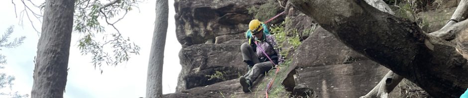
It took us about 1/2 an hour to find the route down the 30m cliff-line, the only hint we had was “a burned out tree to put a rope around”. We did have a track log from my acquaintance, but when we got to the grid reference, we were initially flummoxed! Mind you, when we identified the spot, I was wondering what was taking them so long to rig the tape for the hand-line down, then found out that they were waiting for a small snake to move itself before they called me over to look at the pitch LOL, knowing that if I saw the snake I’d baulk at descending!

This gives a better idea of how exposed we were coming down the pass (photo: Nicole)

Nicole descending, you can just see the purple and red tube tape that we used as a hand-line. The old ladder you can see had been assembled about 30 years ago (more about that later).

We set up another tape for the last 5m down to the bottom of the cliff (Nicole was the first one down).

Jim making his way down the last pitch.

Trish “here’s the overhang (cave)” we’re finally here. It was about 3pm, we’d arrived around the time I’d predicted, would have been there sooner if we could have found the route down earlier.

Trish … “where can we put our sleeping bags, not the best camp cave I’ve seen!”
So, why are we here? My acquaintance was trying to replicate part of a trip that had been done in 1795 by Matthew E (a First Fleeter), John R and William R. Ten months after his return from the walk, Matthew had sent a letter back to the Mother Country describing his journey. Matthew’s account was somewhat sketchy, starting at Parramatta, the trip took 13 days but the jury’s out on where he actually went. In 1995, on the bicentenary of Matthew’s walk, and having established his route, there was a celebratory walk down to a cave that Matthew had described in his letter to England. The ladder that we saw on our descent was erected to accommodate those who were doing the celebratory walk.
In his report, Mattew described a cave “… Capable of holding 200 men”. Here is an extract from Matthew’s letter where he describes a thunderstorm whilst he and his fellow explorers were spending the night in the cave …
“In the night there was some little Rain with a deal of Thunder and lightning. Never in my life was my soul Struck with such awful admiration, the echoing of the Thunder about those terrible Rocks and mountains was sublimely grand, how insignificant the report of a broad side of great Guns appeared to this. It was to the hearer as if the very rocks and mountains were rending from their bottoms, each flash of forked livid fire seem’d regularly to keep time with each dreadful report; when first the flash appeared I could see all the Country before Me, then in a second or two, would come rumbling along the Thunder dreadful to hear. In three or four reports I had entirely lost my hearing and was in a manner petrified. It at last ceased, & became quite calm, the rest of the night tho’ we were very tired was not spent in sleep but in descanting accord’g to our little ability on the awfulness & majesty of [the] Supreme being and our littleness and insignificancy while we stood trembling under a rock at the very terror of his sounds.
As we sat by our campfire, we could just imagine the sound of the thunderstorm reverberating in the gorge that we were looking down upon. There was a log book with more details about the exploration that they undertook attempting to cross the Blue Mountains, amazing undertaking, really humbling.

“Maybe someone could sleep under this ledge!” I think that’s exactly where Jim slept. Sadly, as camping caves go, we rated it 1 out of 10, but for sleeping in the cave that Matthew had slept in in 1795, I give it 10 out of 10!

Trish looking a lot happier with the cave once we all found a spot to sleep (Photo Nicole)

Next morning, Trish “signing us” in the visitor log book.

We headed off next morning at 8.15am, I’d estimated it would take us 1 hour to get to the creek. I determined not to follow the exact route that my acquaintance had followed, and I actually think I found a better route, straight down, no down-climbing or scrambling. (photo: Nicole)

We were at creek level around 9am. Vegetation was a bit thick down towards the creek.

In the creek, and time to pick up some water for the rest of the trip. We were to head upstream to a side creek.

Trish in the pool at the junction of the two creeks – I think she was doing some synchronized swimming – she did have her leg up in the air. Jim swam over to the waterfall and back, but Trish had had enough!

Trish, all dried off and we’re now on a tourist track.

Another great shot by Nicole of the creek we were walking up.

Lovely shot Nicole of the 2nd waterfall and the amazing cliff behind it.

The spot where you cross the creek, identified by cairns.

The track out, well defined, through first rainforest and then dry sclerophyll forest. We each picked up a leech or two.

Looking down at Trish and me from the top of the cliff-line at the end of the walk (nice area) – photo: Nicole
We were back at Nicole’s car at 2.05pm – 5 min past my estimated time. It was nice to get back to the vehicles midafternoon rather than right on dark LOL.
We all agreed that it was a great walk, a bit of history, an adventurous climb down, some exploration, nice section of creek and a great campfire for the night. Big thanks to the guru who shared his notes with me. I’ve withheld actual location and route mainly because of the close proximity to private property and the risk that others will not treat the property as a no-go area.
Big thanks Nicole (for driving so far out of her way for the car shuffle), Trish (for providing the tape) and Jim (for carrying the big tape and a bottle – that’s right a glass bottle of wine into the cave), hope to have more chill walks like this – and let’s pick a date for that Gospers Creek walk!
This one definitely looks like fun!
Yes it was, great weekend last weekend too, ridge walking, you would have loved it!