 NULLARBOR, SA & WA – 22 – 27 April 2023
Last time I visited the Nullarbor caves was 2013. I, like many in the caving community have been waiting for this ASF Conference and its post-conference caving trips for three years now. And here we are, finally. So, Nullarbor Caves here we come!
Saturday 22 – On the Road – Not everyone who signed up for the post-conference trips would be going to the same caves, we were spread out quite a bit, with some going to Bunda Cliffs and others heading to a couple of other campsites. I was keen to come to this campsite because Warbla was one of the few caves on the South Australian side of the border – most of the other caves would be in the Western Australia side of the border.

I’d joined up with Stephie B (from Victoria), in her trusty Hi-Lux which would definitely come into its own with the rough roads expected. Our call-sign on the 2-way radios that most of us had in our cars was Thelma & Louise.

Brief stop to admire the Bunda Cliffs – sadly no whales passing by.

Looking west along the cliffs. Can you see the big crack on the edge – wont be long before this part of the cliff breaks off and drops into ocean below!

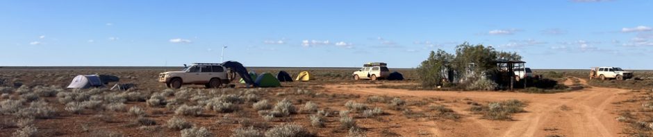
Our campsite for the night at Warbla – Stephie’s roof-top camper on the right, Rod’s car and trailer next to it. Nothing else, no amenities and no water above ground. We carried about 150l of water for the trip.
Sunday 23 – Warbla Cave – not very big, but a large doline, a 15m pitch and a lake at the bottom

The team who would be overseeing everyone into the cave, parked a car at the top of the doline, and anchored the ropes we would need to the car wheels.

Setting up the ropes needed to get into the doline. One rope for a fixed ladder, another for a belay for the ladder and then an abseil rope.

Someone abseiling down to the bottom, I’m sitting away from the fall zone in the bottom lh corner of the photo.

Looking down into the entrance of the cave.

It was about a 30 minute walk down to the “lake” at the bottom of the cave, it probably extended further than what you can see, and it was very, very deep. Apparently cave divers have dived here (you can still see the dive line if you look carefully), the cave view the lake, goes for much longer than what we saw. I love the colour of water that has limestone solution in it, so blue.

Just in from the entrance of the cave, there were heaps of small bones littering the floor. Someone told me it was what’s left over after an owl has had dinner.

Stephie prussiking back up to the top after she’d been down into the cave. It was quite hot by now so most people took off overalls for the prussik.

Paul sat at the top of the pitch helping people get over the edge of the cliff. Most people struggled with getting over the edge, they’d set up a safety to make it easier but didn’t make much difference.

Once we’d completed the purssik up, Stephie and I broke camp just after lunch and backtracked (by ourselves), back to the main road and, back at Border Village, passed through the quarantine check point signifying that we were entering Western Australia.

We found the turn-off (at Eucla) and started to look for the Weebubbie campsite (and doline). Lots of flat grassy plains.

It was getting dark and we still hadn’t reached the doline, but the map & GPS said we were on the right track.

Miraculously, we found the do-line and whilst this was an “official” campsite for the post conference caving, we were the only ones there.

We set up camp in a good spot and after an hour or so, we saw lights approaching and Anne Marie, Stan and Mateja (from Slovenia) joined us and we had a lovely night sitting around a camp fire – amazing that Stan and Mateja could find as much wood as they did. (this photo is next morning!)
Monday 24 – Abrakurrie & Kellys Caves – Anne Marie came over first thing in the morning and suggested that, if we wanted, we could follow them to Abrakurrie and then Kelly’s cave – it seemed like a better solution than trying to find our own way, so we put Weebubbie to the end of our trip on the way back to Ceduna. Abrakurrie has to be one of the most photographed caves around. It’s chambers (2 of them) are massive, with a flat, sandy floor. I hadn’t been to Kellys Cave before so had no expectations.

We set off after Anne Marie’s vehicle and three hours later we were at the Abrakurrie Doline. You can barely see the entrance to the cave. Anne Marie showed me a faster way into the doline, the first time I did this cave we walked all the way down the valley! This time we climbed down to just near the entrance.

This is one cave that “delivers the goods”, massive chambers.

We walked to the end of the cave and found a humidity monitor that Mateja has set up in a number of caves, and she takes her computer in and downloads the data. The data is being used in a paper that Mateja is working on re Cave Climate Monitoring for the Slovenian Academy of Sciences and Arts.

The end of the main chamber. The brown line indicates flood heights from many years ago.

Anne Marie and Stan coming out of the cave.

Stephanie on the rocky slope out of the entrance to the cave. We then all hopped in the vehicles on the way to Kelly Cave and the Webb Cave campsite.
Back on the road, and now on the way to Kelly’s cave. We had to go down to the highway in order to get to the road to Kelly’s, so stopped in at the Mundrabilla Roadhouse for lunch and then over to the Mundrabilla station to say hello to the owners.

Lovely old wagon in the front yard of the homestead.

Part of one of the old buildings at the homestead, evidence of how long the homestead has been there.
Took a couple of hours to get to Kellys, we parked the cars a mere 10m from the entrance. We all agreed that was our sort of caving.

A small hole to climb down, there was a strong wind coming out of the cave. After getting into the hole, it was an easy scramble down.

Mateja’s objective was to find all the data recorders in the cave (I think there were approximately three) and download all the data.

This was a highly decorated cave, and there was plenty of it. Apparently there were two sections, the easy part (here), and then a harder part that was difficult to get down. However, we met up with Megan P coming out of that difficult area and she told Anne Marie about it, so, later on we’d be looking for it.

The ceiling was just covered with straws.

A 1.5m straw just hanging there, signs that this cave was still active!

It was a bonus having Mateja with us as she gave us a running history of the formations, how they formed and how old they were (some were 4,000,000 years old with the new formations maybe 1,000 years old. These stalls on the floor (in the lower chamber) reminded me of a field of clay soldiers.

A column with evidence of a massive movement of the earth.

Sometimes you had to just sit there and admire everything.

Very old formation with new calcite forming over the top.

An one interesting “wedding cake” (the top has been used as a survey marker).
We were underground for around 3 hours then we said farewell to the others and headed over to Webb’s campsite for the night, with the plan to do Webb’s cave in the morning. When we got there we found Graham P and his nephew and great nephew camping there. Graham P is a legend in the caving community.
Tuesday 25 – Webbs & Prostrate Pit Caves – When we got up in the morning, we had a chat and found out that Graham et al were going to go into Webbs so we joined them.

The approach to the Webb doline, you went down a small track and then there was a large “open” entrance, with apparently two ways forward.

Graham took us down the right hand route, apparently the least visited area of the cave. It was such an honour to have Graham with us.

There was a bit of crawling through dusty sand, and then we were in the first section. Again, lots of these old “black” formations.

Graham explained how this formation was created, the drips when floating down, and pushed one way or another by the winds that flow through the cave, resulting in parts of the formation pointing sideways or upwards.

More of the black formations.

Graham pointing something out to me. It was actually quite nerve wracking walking through this area with the straws so close to our heads.
We followed Graham to the next area which was crawling through a “pathway”, I was constantly on edge worried that I’d break something – plus a little over crawling by now!

More straws and Stals.

By now we’re seeing patches of salt “formations”. Apparently, the waves on the coast bash into the rocks/cliffs and salt-spray is formed, this is picked up by coastal winds and carried inland and deposited on the ground. Then, rain falls and the salt is dissolved and carried down through the rock, and settles on what’s underground. This salt formation was one of many that we’d see in the next cave. If you want to you can lick your finger, touch the formation and then taste the salt on your finger.
By now Steph and I had had enough of crawling so we left Graham and his family behind and retraced our steps out of the cave. When we got above ground we discovered that Matt, Minky, Heather, Ian and John had turned up. They were here for a short visit, then would be heading over to do Prostrate Pit and then heading to Witches campsite for the night. This sounded like a good plan so we decided to follow them, easier than trying to find Witches campsite by ourselves!

The convoy.

The vegetation along the route to Prostate Pit, more trees on the Nullarbor than I remembered.

The entrance, pretty easy looking and just a gentle slope down to the chambers, which amazingly aren’t that deep underground.

Straight away we’re into the black formations (the 4,000,000 year od ones).

These formations were blacker than the others, not sure why.

And then we start seeing the salt formations. This one has some straws and from the base of it, it looks as though they’ve been breaking off, whether from weight or the wind through the passage I’m not sure, but it would be highly unlikely that it would be because someone knocked them (too much open ground around them).

More fragile straws.

This was amazing, a ceiling of small straws all over the whole chamber.

We’re now approaching the “Winter Wonderland” as it’s been called. Some of the formations are calcite, but the really white ones are salt formations.

There’s only a small passageway you can crawl through to see the formations and then you can sit and enjoy them before heading back out.

The majority of the cave has had route markings put in place so people stay in the designated areas. Some of us eventually went to a circular passageway, whilst the others stayed in the first chamber.

More of the formations, with breakages on the ground.

Looking through to another passage, but we decided that it was too fragile to go any further.

Continuing our circular route on the marked track.

Looking up to the ceiling, I found this one patch of gypsum crystals, only as large as my finger, very delicate, if you weren’t careful, you’d beak them.

The whole cave was a photographer’s dream come true, so much to see and photograph.
After having our fill of Prostrate Pit, we drove for about an hour to the Witches campsite where we’d stay the night. It rained almost all night but conveniently stopped around 4am! Before we went to bed, we made plans for the next day. We’d join Matt’s group and drive with them to do Matilda and The Sentinel Caves, and then we’d follow them over to Old Homestead for the cave rescue exercise on Thursday.
Wednesday 26 – Matilda & The Sentinel Caves – We didn’t know anything about either Matilda or Sentinel – but we had it on good authority that both caves were worth a visit. Steph and I set off at 8am with Matt, Heather, Minky, Ian and John. Didn’t take us long to get to the first cave Matilda.

It was a 400m walk to the cave, initially through some nice trees. Beautiful day, we hung our wet tents out to dry while we were caving.

Then out onto a flat plain with little vegetation.

The entrance to the cave looked a little dodgy, I was happy for Minky to go down first (lol).

John looking down from the top before the climb down.

You had to walk along a bit of a ledge, which frankly looked like if you stepped in the wrong place the whole wall would collapse. I went on my hands and knees in the dodgiest place.

Once inside, the cave was highly decorated. We spent a lot of time photographing.

All over the Nullarbor, there are Black Calcite speleothems, however they are quite rare. A paper on black calcite speleothems was delivered at the Conference. Apparently the blackness is caused by a humic compound, formed when the area was much wetter than now. Apparently, back in the 1990s the speleothems were “too old to be dated, but someone on the trip said that they had now been dated at 4,000,000 years old.

More black calcite.

Gives you a bit of an idea obout the type of cave we’re in, quite a bit of decoration to be avoided.

You could go through this hole, but it was highly decorated beyond and we felt the risk was too high.

Nice column in the middle of the chamber.

More black calcite – we spent a lot of time photographing this cave.

On the way out, we found these “holes” in the limestone which had these lovely crystals in them. There were about 6 of these holes, all about 30 – 40cm wide and about 20cm high and deep.

More of these beautiful cyrstals.

The climb out, both Steph and I took the safe route and crawled until we were safe.
We were out of the cave by 10.20am and walked the 400m back to the cars and were on our way to Sentinel.

This is the entry to Sentinel.

When I first went into the entry chamber, there was this big stal at the bottom, and I thought, well there is the Sentinel. The rocks at the back of the entrance have a lot of green on them because there is so much sunlight at the entrance.

We walked for quite a while, it mostly flat but with some ups and downs, often with a lot of rocks to negotiate up and down.

One of the rocky slopes that we had to negotiate. We’d gone up the next small hill of rocks and I’d decided that I’d had enough and told the others that if there was anything of interest to let me know. Next thing I hear is come on through Marilyn you’ve got to see this.

And there we were at the end of the chamber and passageway and there were these two huge stals, the small one was at least 6m and the other one had to be 10m.

For some scale, down in the bottom lh corner is a person.
We were out of the cave around 3pm and then started the long drive (3 hours) to Old Homestead. The road was very, very rough and slow going. The convoy of 4 cars with Steph and me in the middle was a godsend. We were going along ok, probably 2 1/2 hours into the trip and we accidentally hit a rock. “I think we’ve got a flat tyre” says Steph. Unfortunately, the spare was in a hard to get to place but fortunately we had Ian and John behind us so they gave Steph a hand – I just sat around watching them!

There were lots of challenges – hard to get the spare tyre from where it had been for a long time (under the back of the car), difficulty with jacking it up due to soft sand, hard to get the nuts off, all our gear covering everything that was needed. But eventually it was all sorted, again, big thanks to John and Ian!
Thursday 27 – Old Homestead – By the time we got the tyre fixed it was dark when we rocked up to Old Homestead on Wednesday night.

The hut and all of our cars around it. The hut is a godsend. It was originally a property hut built for those working on the property, it has a table and chairs and is great when the wind blows.

You can see there aren’t many trees or bushes to “dig a hole behind”, so some very nice cavers in the past built a “long drop” toilet (you can just see it on the horizon). it’s not as long a walk as it looks, only 75m from the Old Homestead hut.
We spent all of Thursday doing the cave rescue exercise (subject of another blog post). During the course of the day, Steph had had a chat with John C and determined that it was best that we not do what everyone else was doing on Friday. Steph didn’t have another spare tyre. If we’d followed everyone else and done another day of caving, there’s a chance we would have had another flat. In which case, Steph would have to get a ride (with the bung tyres) somewhere to have them fixed, who knows how long that would have taken. There wouldn’t have been room for me in that car (all the vehicles were totally full of gear), so I would have had to camp beside the car until she came back for me (I had enough food and water so that wouldn’t have been unsafe). So, she decided that it was better all round if we followed John out to the highway where there was less chance of a flat.
So, on Friday we pulled up camp, said goodby to everyone and then set off with John. It was three hours back to the highway and then another seven hours to Ceduna and a hot shower and soft bed! We took our time and were back in Ceduna by 5pm.

The last gate to close at Mundrabilla, me on gate duty, John up ahead.

The trusty car at Mundrabilla Roadhouse – amazingly it looked lovely and clean after 2 hours at the car-wash in Ceduna.
Big thanks to John C for accompanying us to the Highway. And Huge thanks to Stephie for your company and offering me a ride, and for all the photos you shared me (the post wouldn’t look like it does without some of Stephie’s images).
It was a great trip, lots of laughs and we came out the other side unscathed! Will I be back? Who knows! Would I recommend anyone caving the Nullarbor – hell yes!
Another amazing adventure !!!!
Thanks Linda!