 KULNURA – 29 May 2022
Another skills development day, this time navigation practice in the Kulnura area – and a fitness walk for me (part of my get fit phase).
I spent quite some time pouring over the Kulnura map looking for a challenging route for some navigation practice – I sure as hell needed it, it’s been years since I walked a bearing on a trip! My main problem was whether or not I’d be able to drive down a fire trail – without encountering fallen trees and washed away roads. Finally came up with a nice little route and a nice fitness walk for me.
Kavita, Ali and Catherine joined me – they’ve been learning to navigate and wanted a bit of practice.
Spoiler alert – I’d attached my camera to my backpack, but I couldn’t actually see the screen, so my photos towards the end are crap! Usually I attach the camera (on my big backpacks) to the shoulder strap and that works fine, but the pack I was using didn’t have a good shoulder strap – that will teach me to use the teeny tiny backpack!

Once we’d confirmed where we were starting from, everyone took a bearing and started walking – one of the main points for the whole day was to look at the terrain surrounding you and adjusting your route to take into account the easiest route. Photos start out ok but get progressively worse!!

Setting another bearing, and learning how to walk the bearing by looking ahead to a particular feature on your bearing to walk towards.

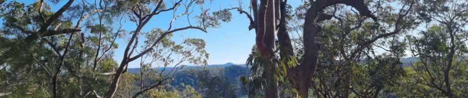
We were ale to see Mount Yengo in the distance (on the horizon) – stunning weather eh? Photo Kavita)

Half way through out route and a massive change in direction, lots of comparing of what bearings they should now be taking.

I’ve walked a lot in this area, and I have to say, this ridge (for 99% of the trip) was absolutely fabulous walking, no scrub, lovely open country.

Kavita’s shot with her phone – much better than my under exposure! Bloody camera – but in truth, it’s the user!

At the end of the ridge, we needed to decide exactly where we wanted to go to get over to the exit route, had to drop about 100m in elevation to get down to a creek we needed to cross, was in the main easy until we got into some horrific scrub, but it was short lived.

Kavita’s shot of us descending the spur.

Down at the creek, I was a little concerned, with all the rain we’ve had over the past 6 months, this creek might have had a LOT of water in it, but, when we arrived, it was an easy crossing. Before we got there though Kavita had a close encounter with a Red Bellied Black snake!

Me crossing the creek – shows up how under exposed my shots are LOL (photo Kavita)

Starting up the spur which would take us up to a fire trail, our easy route out.

On our way up the hill I spotted a Pterostylis, aka a Winter orchid. I used to have these growing in he grass in a house I lived in 20+ years ago, the flower is about the size of your finger nail. (photo Kavita)

We ran into a cliff wall on the way up the spur so had to detour through all this fern, freaked Catherine out a little, thinking of snakes, until I assured her that any self respecting snake would be in the sun, not in the shade.

On the fire trail, three happy campers holding up their compasses! well done ladies!
Was a great day walk, we were back at the cars by 3pm, was a good fitness walk for me and the ladies were very happy with their navigation – now I have to come up with a harder route! Thanks Ali, Kavita and Catherine for joining me on this mini adventure.
Hi Marilyn
In that area try McPherson Forest, good access & plenty of exercise, cross down to the old school ruins somewhere around 56H 325E 632N GDA datum, there are also old sawmill ruins in this area.
Wish I was capable of joining you.
Regards
Doug
Thanks Doug, will set them this task! Hope you’re doing well, and yep, wish you could join us too!