 WOLLANGAMBE – 16 -17 December 2021
Some years ago, Jeff, Trish and I did our epic trip down the Wollangambe River from The Centre of the Universe down to the Wollangambe 1 Entry track. Since then, I’ve had in mind to go back and camp on the bank of the Wollangambe at the end of an interesting looking unnamed creek. We’d passed this campsite on the epic trip. The plan was to walk all the way down this creek and see what the canyon sections were like.
Then we’d have a leisurely camp on the bank of the Wollangambe and then reverse 750m up the Wollangambe to the Crater campsite. The only iffy spot would be the 750m upstream section, and a possible waterfall to traverse around in the side creek.
I knew it wasn’t going to be an easy trip, but Anna, Ali and Steve R, offered to join me, couldn’t have done it without them!
Things didn’t start off well on the Thursday morning, I got up around 5am to drive up to Mt Wilson with Steve, and felt really “off”. Not well at all, but as I was the leader, I didn’t want to cancel the trip. Then I tried to get my garage door to open and it wouldn’t open, had to get Steve to open it manually! We’re not off to a good start. Nevertheless, after a couple of stops on the way up there, we all met up (albeit a little later than I would have liked to start).

The trip down to our creek (a small creek you cross on the Wollangambe Crater was no problem, was hotter than expected (it was cloudy all the way up to Mt Wilson), but we got to the creek by about 10am and had a rest. Great flannel flower display along the way.

We headed down the creek (named by Anna as “M’s Creek”). The scrub wasn’t as bad as it could have been, considering this area had been smashed by the 2020 fire(s).

We had a few crossings of the creek where the walking was easier. Anna found a bark hammock at this creek crossing (that she intentionally laid down on).

Then Ali attempted to cross it (gingerly).

And her foot went right through the bark!

Up to this point it’s been fairly easy going, but we’re in full sun and it’s getting hotter and hotter, and my energy level is dropping really, really fast. Still wasn’t feeling 100%.

And now the scrub is getting thicker and it’s not nice walking on the banks. And if you walked in the creek you were either sinking in quick sand, or climbing over logs and fiddlesticks.

By 11am we stopped here for a rest. By now I’ve got no energy at all, it was cool in the shade but other than the small spots of shade the sun was punishing.
Looking at the map, we’d travelled less than 1.5k and we had another 3+k to go to get to our campsite for the night. We were at an “exit point” and the next one was 2k away if we decided that we’d had enough. There was no guarantee that the creek was going to get any better, it’s name had been changed from “M’s Creek” to “Sh#t Creek”, that’s how bad it was. The post fire regrowth was horrible! So, we discussed our options and decided that exiting at this point and walking 2k to The Centre of the Universe and the tourist track was sounding like a good idea. We’d then walk down to the camp cave on the Wollangambe and spend a leisurely afternoon and evening there!

So, we started to negotiate the exit route, Anna leading the way.

Very scrubby on the way up and lots of dead trees to negotiate.

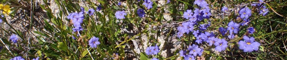
We followed the spur up, up and up to a high point, really easy walking on top of the ridge. Plus great scenery and wild flowers. (Photo: Steve)

After a little over a k we could see The Centre of the Universe (a group of pagodas – at least that’s what I’m calling it). On the map it looked like it was an easy route, but there was a big drop off ahead of us and to one side, maybe it wouldn’t go, but we’d certainly try it. We had a quick lunch and then headed up.
It was easier than expected and we were soon on the tourist track. At the junction to go to the Crater, Anna and I divested ourselves of some of our heavy stuff (dry bags, wet suits, extra thermals, helmets – anything to lessen the weight we were carrying).
We then headed off, it’s a fairly easy track to follow (expect for the one spot we lost it), but there’s lots of ups and downs, I had absolutely no energy and had a lot of rest stops. Finally we came to the last high point and I took us off track to get down to the camp cave. Approaching from this spot meant that we had to keep our eyes wide open to see the route back down to the river.

Once we were down, the others found a good log to cross on, I chose to get wet instead, wasn’t up to a log crossing. You can see the cliff line in the distance that we walked down looking for the negotiable route down to the river, once we found it there were no issues getting down.

I was a bit nervous about Anna crossing on the log, she’s had a few falls lately, but she really wanted to cross to get her confidence back!

The camp cave, our home for the night. Steve got a good fire going and we had dinner and relaxed, mist/drizzle started falling just after dark, so we were lucky we had good shelter.

Next morning, we packed up walked around to the Crater campsite, then Steve and Ali did a quick trip over to the Crater and Anna and I made our (slow) way on the track up to the first high point. We took a quick stop at this lovely field of flannel flowers.

Joined now by Steve and Ali in probably the best display of flannel flowers I’ve ever seen.

Approaching one of the high points (possibly the one where we lost the track when it went across a rock platform lol).

We came across this fabulous display of Trigger Plants (Stylidium). It was like a field of bonsai plants.

Steve’s photo of the same bonsai garden.

And we were lucky enough to find some terrestrial orchids. This is my photo of the Flying Duck orchid.

Steve’s shot of the flying duck orchid.

We came across this dew covered plant, we’re not sure if the red flowers are just about to flower, or they’re past their use-by date. (Photo: Steve)

Another terrestrial orchid, both times we’d just sat down for a rest and there right beside Steve were the orchids!
It took us longer than expected to walk back to the Centre of the Universe and pick up our gear, it was another really hot day and lots of rests were required. I was feeling better but still not 100%.
We had lunch down at the creek where we’d started this epic adventure, in the shade, and Steve boiled the billy for a cuppa. It was then a 1 hour walk (all up hill) back to the cars.
Ali and Anna went home and Steve and I went to Mt Wilson to camp, ready for the following day’s abseiling (would I be up for it, am I really this unfit?).
Thanks Steve, Ali and Anna for coming on the trip with me. I obviously didn’t put them off as much as I thought I did, especially Steve (who usually vows he’ll never go on another adventure with M). Both Steve and Ali were talking about how to do it next time (lol), we’ll see! As for me, I’m so unfit, off to join the gym!
Sounds like illness not fitness. I remember that time I came down with flu on a kowmung long weekend trip. A bit delirious by the time we got back.
Yes, we sometimes push ourselves too much!
Ah M,
Nature’s gym is the ‘best place’ for exercise & fitness. Where else do you get to see the fantastic beauty of the current crop of wildflowers – & of course, the ‘flying ducks’?
Serendipity Canyon is a good place to start – so long as you can hack the frigid water! Plus, no burnt trees/scrub to negotiate either.
BTW, National Parks has now given this one a rating of “EXTREME” – just perfect for one who always survives the test!
Yes, must get back to Serendipity!
Beautiful flowers! Thanks for sharing!
Yes, wild flowers this year are stunning – always happens after a big bushfire followed by lots of rain!
Sorry to hear you were unwell. Glad you did not have to be helicoptered out!
The photos were amazing ! thank you .