 DHARUG NATIONAL PARK – 8 – 10 June 2019
I first started exploring this area in 2015, looking for a “grassy meadow” campsite in the headwaters of Sugee Bag Creek. Didn’t find one on that occasion, nor on the 3 or 4 times that I returned. But something kept drawing me back to the area, particularly 500m of “gorge-like” creek that had “canyon” written all over it. So, Heather (who’ll go anywhere with me) and Stalwart Steve agreed to go with me on what I initially thought might be an “epic” trip.
I poured over the maps in the week prior to the walk, and on closer inspection, had to revise my thoughts of an epic trip, wondering if there was even a full 3-day route there, 2 days maybe, what would we do on the third day? Eventually I settled on a circuitous route that would give us a possible campsite at the end of each day with guaranteed water and some ridges with views (just for you Steve). Given that I’d be doing the navigation for the whole trip (talk about pressure), I wasn’t overly confident that we’d stick to the route (lol).
As it turned out, we did only 1/4 of the planned route!

Looking at the map, it seemed there was easy access to within a k of the “gorge”. A hazard reduction burn had been conducted in the last few months and all of one side of the fire trail had been burned, the other side (on the right), was green-as.

Half way up the hill was a small cave, we figured we’d check it out and, what do you know, a few hand stencils, unexpected, but in reality, this area is rich in Aboriginal art sites, so we shouldn’t have been surprised.

Whilst the weather for Sunday and Monday was good, Saturday’s weather forecast was “cloudy”, where we were though, we were walking in mist for most of the morning. Very pretty and ethereal.

Lots of wildflowers which was surprising, this is a Geebung (there are many varieties).

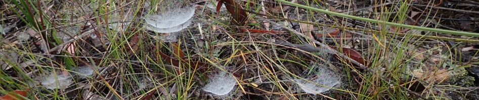
We also came across these small cobwebs, they are concave in shape and the high humidity covered them in dew.
We got to the point on the track that I had chosen to take us down to the headwaters of our creek. We had morning tea at around 10.30 and then headed off. We climbed to the top of a knoll.

Straight away we were in the burned out area, I didn’t like walking through this at all, everything you touched made you black with soot. It was a “controlled” burn so the fire wasn’t allowed to get so hot that it spread quickly, nor hot enough to reach the top of the trees, just the ground cover and small bushes were burned. AND, because of the mist that we’d thought was so nice to look at, all the vegetation was wet, so in less than 10 minutes, we were all soaked through.

We came across our first “camp cave”, this one with a perfectly flat floor, only enough room for one person though (or two very good friends).

After reaching a saddle we decided to contour around a big hill and then drop down into the creek.

We had a few small drops to negotiate, the tape came in handy on this one.

Steve about to drop down. The vegetation was what you would expect at this point, not too scrubby and it was easy to pick a route down.

At the creek, the team gave it the “thumbs down”. The banks were scrubby and getting over to the other side (less scrubby) would involve getting wet feet, there was some push-back about that, so we headed up higher to contour acros,s whilst at the same time heading downstream. By this time it was around noon, so we had lunch.
Contouring was a BIG mistake! The scrub was horrific and there was a lot of muttering and cursing from the team. Against my better judgement we headed higher, and higher, and the scrub was unrelenting. AND the vegetation was way wetter than in the burned out areas, so anything that had managed initially to stay dry was soaked through.

Heather endeavouring to get through this tangle of low scrub, the only thing for it was to lay down flat.

We did find some stalactites in this overhang, these were about 6 inches long, they’re out of focus because I had to lay flat on my back to take the pic.

The overhung section where the stals were. You can see here that the vegetation isn’t burned out. We wanted to head to the burned out part where it would be easier going.

But first we had to get through this tangle (a mere metre from where Heather had been standing in the previous photo). The only way through was hands and knees.
By 3.30 it was obvious that we weren’t going to make our proposed campsite, it will be hard to believe, but since lunch, we’d travelled less than 1k! I know we were slow, but was it because we were having an off day, surely the scrub wasn’t that bad – it was worse than any Ettrema Scrub that I’d been through, but hard to believe that we’d been that slow!
We decided that we’d find a spot to camp on the spur that we were on, we were about 250m away from water but Steve would go get water for all of us while Heather and I set up camp. We were all soaking wet, so stopping for the day was the smart thing to do. Collecting fire wood was not all that easy, most of it had burned in the hazard reduction. I wasn’t keen to camp in the burned out area, but that was the only open spot, we were blessed with a rock slab though so we weren’t setting up camp actually on the ash!

Next morning we were presented with a beautiful sunny day. The previous night we’d debated the wisdom of sticking to the original route/plan. We had no idea what the ridges were like and if the scrub was as bad as what we’d encountered, the three day walk would be more like 5 days. So we decided to make this spot our base camp and do a day walk to where we’d originally intended camping (destination for day 1), and make it an easy day. After all Heather reminded me, it was all about exploring the area.

When the sun came up the valley was filled with mist, very pretty (the view from my tent).

On Steve’s quest for water the previous afternoon, he’d found that this burned out stretch extended almost down to our creek, so we stuck to it – not as pretty but less scrub.

Within 30 minutes were we’re down to our creek, about 1k from where we had dropped down the day before, what a difference in 1k – we should have stayed in the creek!

We soon came to a slabby part of the creek, this is what I had expected (should have stayed in the f-ing creek!).

Looking upstream.

Before long, we were in the canyon-like section shown on the map, wasn’t really a canyon, but there were good cliffs either side.

Not too far from the junction we were heading for, we found a great camp cave, would sleep about four.
Walking down this section (about 500m) of creek was very easy, a bit of rock hopping but we could easily walk on the banks which were quite open with very little under-story vegetation. We reached the junction of two creeks (which was a possibly campsite on my map), and Steve decided that he’d stop there and wait for us to come back from our exploration upstream. As it turned out, camping here would have been a bad idea, very little dry wood, we were in rainforest vegetation now and it was very damp.
Heather and I then walked upstream, heading for a waterfall (about 1k upstream) that Steve and I had walked to a few years ago (walking in from the west). Again, the vegetation wasn’t too bad and we were able to easily walk on the banks. We looked across and could see what looked like a flat ledge running alongside the creek, about 10m up from the creek bed. Heather thought it looked like an old fire trail, but I couldn’t believe there’d be one there, after all I hadn’t seen one upstream when I was with Steve years ago.

We spotted another camp cave, so went up to check it out (again nice and flat, not as good as the first one we found though). We dropped down to the level of the fire trail that Heather suspected was there, and what do you know, there was an obvious bull-dozed track!

And a little further upstream, there was this tree that had obviously been felled by timber-getters (you can just see the slot in the side where they used to put in the wood to stand on to saw the tree) maybe the trail that we’d found was used to take the timber out.

Nice section of creek with a big pool.

Small 2m waterfall which we could easily scramble around and up above so we could check out further upstream.

Good slabby section of rock above the waterfall. I was hoping that the slabby part of the creek would continue to make it easier going for us as we weren’t making too much headway towards the waterfall we were heading for.

Unfortunately we were back into a scrubby section again. We’d been gone for about an hour and a half, so we thought we’d best turn around – we couldn’t leave Steve back at the junction for too much longer.
I headed up onto the side of the creek and picked up the bull-dozed trail and followed that for a few hundred metres, it seemed to be getting too high (maybe 50m above the creek-bed) and heading around to head a gully (plus it was really overgrown), so I headed back down to Heather in the creek.

Lovely old tree in the creek-bed.

We got back to Steve at the junction at around 1.30pm. He’d started a fire (it took him an hour to start it, the wood was so damp), we had lunch and then said “we’ll just check over the other side of the creek, we should only be 10 minutes or so)”.
Straight away, on the other side of the side creek, we picked up another bull-dozed trail, but then it “disappeared” maybe under a rock-fall.

Then further downstream we picked up another bull-dozed trail. What were they doing up here, must be from the farm way downstream on Mangrove Creek. This trail was really nice, very open and easy walking.

It was about 60m up from the creek-bed and Sugee Bag was very narrow at this point and quite bouldery, so it was much easier up on the trail. We’d been gone longer than our 10 minutes so retraced our steps on the track, which took us right to the junction (albiet 50m above it), where we scrambled down to Steve.
More questions – where does the track go, what’s it doing there, and where does it come out?

We got back to camp by 4pm, collected a good supply of firewood and then cleaned up, ready for dinner. Heather made us chocolate mousse with dehyd strawberries, it’s becoming one of her “signature” dishes at the end of an overnight walk, thanks Heather!

We headed out at 9am next morning, taking a bearing that would get us back to the fire trail. A bit of rock scrambling and a lot of walking through burned out vegetation.

Back at the fire trail by 10.30am.
As we had a bit of time up our sleeves, we headed further along the fire trail to what I hoped was an aboriginal art site that I’d read about.

Whilst we found a big rock slab, the only thing that was remotely like a petroglyph was this which looked a bit like a dinosaur to me (and an emu to Heather), but it was really just a crack in the rock. Will have to do a bit more research!
We were down at the public road by 12.30pm. We’d walked almost all the way back to the car, when a ute came along.

Turned out that Heather knew the driver so he gave us a lift the rest of the way back to Steve’s car, but more importantly, he was the manager of a property which would give us easy access to the section of creek that we’d been exploring, PLUS he gave us the low-down on the bull-dozed trails. Apparently they were put in by the Rural Fire Service back in the 1980s when there were some serious fires in the area, so, some of them “don’t go anywhere”, but they are still worth exploring.

Sugee Bag Creek downstream where we’d parked the car.
So, didn’t quite do the walk as planned, but I did get to see the parts of the creek that I’d wanted to check out. And, we have come up with some easier walks that we can do in the future – which is I guess what an exploratory walk is all about.
Thanks so much for joining me Steve and Heather and for your good humour (well most of the time) through the scrub.
Thumbnail: fungus in the rainforest
Banner: dew on the delicate cobwebs