 YENGO NATIONAL PARK – 11 & 12 May 2019
Yengo Trail > Tumbledown Ridge > Tumbledown Creek > Nowlands Creek > Nowlands Ridge > Yengo Trail
Back in June 2010, I did a recce day walk out to Nowlands Track with a few BWOC friends, just sniffing the place out. Then in December 2010 I put on an overnight walk to Nowlands with the intention of exiting via Tumbledown. Due to a number of reasons (heat – FFS it was December what was I thinking – scratchy scrub, bull ants and a navigational error on my part), all we did was the Nowlands Ridge part of the walk down to Sandy Creek. When doing my “wish list”, for some reason I added this walk to it as “unfinished business”. Maybe I should have read the trip report from the December walk!
Jeff, Heather (who’ll go anywhere with me), Paul and Norm joined me for the weekend. I wasn’t sure it would be a great walk after looking at Six Maps and finding there were fire trails all over the place, you’d have to try really hard to get off track (I didn’t know about Six Maps in 2010).
AND, I should have read the trip report, I noted “the scrub was much thicker than anticipated” after the recce in 2010; and my conclusion after the December overnight walk was “the jury is still out as to whether or not this area is worth a second look, I’m up for it, surely all those ridges and spurs can’t be covered with scratchy scrub”! Well, the answer is yes, there’s a lot of scratchy scrub there (too much).
The downside of the trip, is that there had been no significant rain recently, and no guarantee we’d find water, so we all carried enough for the whole weekend. Jeff carried an extra litre for me (brining his water weight up to 6.8k), and I carried around 3.5k of water.

We set off on a fire trail, and after a couple of k, headed off-track. Jeff was helping me navigate the trip using map and compass and Heather was trying to use just GPS and see if she could apply it to the map.

Initially the route was ok, not too much scrub, but it steadily worsened the further away from the fire trail we got. We discovered fairly early on the difficulty of navigating this ridge, very small features, many of which weren’t on the map.
When discussing the route, Jeff and I had determined that there were a few spots where we had to be particularly vigilant not to go down the wrong spur, and sure enough, at the precise spot where Jeff thought we would have trouble, we found ourselves at a steep drop, which we definitely shouldn’t have encountered. So, we backtracked, not once but twice, and eventually were back on our desired route.

By this time the vegetation wasn’t as scratchy as it was early on, nice open forest.

I had identified a rock platform on the satellite images of six maps, and I thought there might be camp caves there. We came across this rock platform, probably not the one I identified, but it was good enough, and we had the opportunity to take a spur down to Tumbledown Creek, so we opted to drop down into the creek. This would have the added advantage of giving us more creek to explore, looking for water, and more options for camp sites.

Dropping down off the rock platform we found some wind caves, here there’s a lyre bird’s nest on a rock shelf on the left.

The way down wasn’t too bad, steep but plenty of trees to hold onto.

Then we dropped out onto an old fire trail (which was expected), by this time it’s getting late (about 3.30pm) and we needed to make the decision to take the fire trail (twice the distance) or drop into the creek and see what that was like. Again, I decided to take the creek, mainly to see if there was water in it, Jeff (who hates fire trails) was all for the creek, saying it was only 50m away.

So we headed down and immediately were in thick myrtle, and the route felt more like 100m not 50!

When we got there though, the creek was nice, no water but easy walking.

By 4.30pm we’d found a decent campsite, in hindsight, we were lucky we dropped into the creek where we did because we discovered that this was probably the best campsite (with the most flat spaces) in the who section that we walked (on Saturday & Sunday).
On Sunday we looked at the map and planned out route. We had a few options, fire trails all over the place that we could use as a quick exit, or continue downstream to the junction of Nowlands & Tumbledown Creeks (and check out if there was a campsite there – there was), then upstream on Nowlands to see what it was like, if there was good water, and to check out a big cleared area. At that point we’d then make the decision to exit on a fire trail, or go up a convenient spur to the top of Nowlands Ridge.

On Sunday morning, continuing downstream – from time to time we came to a pool of water, but it was very manky and animals had been foraging around at most of the waterholes, so would have taken a long time to get potable water out of any of them.

Occasionally, we’d come across rock falls in the creek, but they were pretty easy to walk around on the bank.
We were at the junction of Nowlands & Tumbledown Creeks by 9.30am, there’s a nice campsite up on the right (note for future use). Nowlands at the junction didn’t look pretty, lots of vegetation to walk through, “this isn’t going to be pretty”, so again we considered the options, climb out to the fire trail, or give the creek a chance?

The creek won and after 10m of scrub it opened out and was very easy walking. Again, we found pools of water from time to time, but all manky looking.

We were rewarded by our first grassy meadow (not the one on Six Maps though), we decided that after rain (when you would have water in the creek), this would be a 10 point campsite, lots of firewood, grassy flat areas to camp and wood nearby, and it was close to the fire trail (easy walk in with a heavy pack, loaded with wine and steaks to cook on the fire). Heather way-pointed it as the “old farts campsite”, ie. we could go to it when we were much older and grayer.

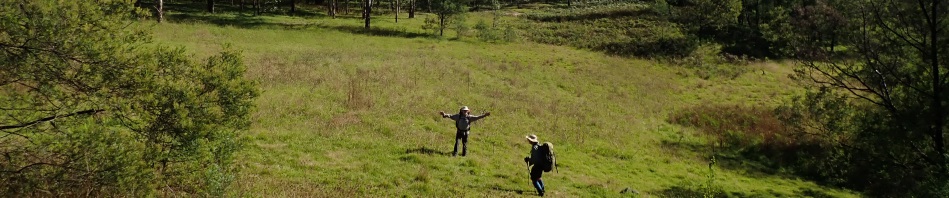
Another k upstream was the grassy meadow, it was a very Sound of Music moment looking out across the field (we briefly sang the opening words – all that we knew – “the hills are alive with the sound of music, la la la laaaa”).

Lots of ant hills in the whole of Yengo, not worth noting but this one surrounded by the moss was cool.

Unfortunately the grassy meadow was full of Farmers Friends, noxious weeds with seeds at the end of summer that stick to you, Jeff de-seeding himself at the morning tea spot.

We walked further on, and again were covered in the seeds. We took care to de-seed ourselves before we got back in the un-infested part of the creek (upstream).

Also found this noxious weed, Prickly Pear, in fruit.

I’d heard that you could eat the fruit, looks poisonous when you open it up though.

Heather was the only one game enough to taste it, but then found she had spikes from the fruit in all her fingers!

Walking further upstream, we came to an eroded rock, almost a cave.

With a hole in it that Norm was able to put his hand right through.

As far as creeks go, this was a really good one to walk up, not scrubby like most very easy walking.

But eventually we started coming to rock falls, and decided that now was as good a time as any to take a spur up to the ridge.

Initially it was quite steep, but not that scrubby.

By 11.30 we were on top and the vegetation was fantastic, nice and open, easy walking.

Lovely new leaves on a eucalypt.
On the ridge, once again you had to concentrate on the navigation, there were a few spots where you had to make sure you took the right route off a knoll. Everything went well until after lunch, when we were getting close to intersecting with the fire trail. We lost concentration and inadvertently walked 200m over to what we knew was the wrong spot as soon as we got there, retraced our steps, and discovered that where we went off-route was only 50m from the fire trail – you get that, particularly at the end of the day when everyone is tired!

Once on the fire trail, it was all smooth sailing, the fire trails at Yengo are great, whilst they have locked gates across them, they’re in extremely good condition.
Jeff and Paul walked on ahead of the rest of us (they are way fast), and went to retrieve the cars from the start of Tumbledown Ridge. I could have walked the extra 2k, but it was nice not to have to do the steep down and up on that section of road – thanks Jeff!
So, would I go back there? Well, (1) the upside is it’s only 2 hours from the Central Coast and you don’t have to drive through Sydney traffic, so it has that going for it. (2) You can obtain the key to the locked gate at Nowlands Ridge from NPWS, so with the key, it’s very attractive as an (almost) car camp, ie, you could drive almost all the way to a wilderness campsite and then walk in with a heavy pack (wine, cheeses, steaks and salad), and have a lovely campfire. OR, (3) if you just want a track walk, the fire trails are great, easy access to any part of this walk on fire trail, with just a short off-track section to get to the nice campsites. So, I guess the answer is yes, I’d go back, but probably not through the scratchy parts of the ridge again, and probably after a major rain event, so there was guaranteed water.
Thank you so much Jeff for navigating, and for joining us on the walk Heather. A BIG thanks to Norm and Paul for coming on the walk, it was their first walk with us, very brave of them to head off into the wilderness with people they didn’t know, with unknown experience, we really enjoyed your company around the campfire on Saturday, lovely to meet you both.
So, where to next?
Banner: Our grassy meadow – that I’ve been searching for for years!
Thumbnail: Prickly Pear fruit
Snake Count: 0
Another beautiful walk! Glad to hear you call them Farmer’s Friends too. Most people have no idea what I am talking about when I use that name!
Not very friendly either, had an inspiration this morning that maybe NPWS will give me unlimited access if I offer to eradicate them, but then decided it was too big a job for just one person!
What a great walk report. Unfortunately I’m in the old fart category but still mucking around in the bush looking for the type of campsites you mention, it looked special!
What a great walk report! Unfortunately I’m in the old fart category but still mucking around in the bush looking for special campsites like the one you found.
Ah Morrie, we’re all in that category these days! Yes, great to find campsites that can be easily accessed for the future.