 ETTREMA – THE WAVE CAVE – 13 – 14 October 2018
After a week of rain up and down the east coast of NSW, I was struggling with the idea of walking down Tail Race Creek (on wet rock in the 1-5ml of forecast showers), camping on the Shoalhaven (in the forecast rain) and then walking out on Sunday (again in 1-5ml of drizzle/ showers). So, just in case, I came up with a Plan B.
Trish, Heather and I drove down to Nerriga on Friday afternoon, meeting up at the pub for dinner, then heading off to a campsite beside the Endrick River. Heather very kindly allowed me to sleep in her caravan as I wasn’t at all keen to put up my tent on the wet muddy/grassy ground.
We met up with Murray and Emma back at the pub on Saturday morning and discussed the weather (Jeff sent me an update while we were talking). It didn’t look good, the skies were already threatening and showers/rain/drizzle was forecast for Nerriga. So we discussed our options and decided that Tail Race should be done in good weather and we’d do Plan B … head over to The Wave Cave (where we were guaranteed to be dry for the night), and next morning do a day walk in the headwaters of Ettrema Creek. The upside of this is that I was ticking off another Wish List trip as The Wave Cave was on it.
Murray & Emma had actually done this as a day trip some time ago, so Murray was in charge of getting us there. We drove to a fire trail, sadly didn’t take the right fork but took the left one, which meant we had 500m of scrub bashing to get on the right ridge/spur.

Almost as soon as we took off, I found these little orchids, they must come out after rain, no leaves, just the orchid sticking up out of the ground (about finger-nail size).

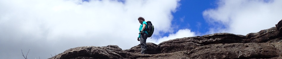
After our run-in with the scrub, we were then on the right ridge and came to one of the rock slabs that Ettrema is known for, sure makes walking easy.

More easy going bush, and blue sky started to appear (where was the forecast drizzle?).

Murray unerringly led us to the pass we needed to go down (Murray & Trish looking at the way ahead).

As passes through cliff-lines go, it had to be one of the easiest we’ve come across, Heather on one of the few slippery descents that were easily avoided by a bum-slide.

We were soon at the creek and straight up the other side.

A little scrubby, but nothing compared to how bad it could have been.

15 minutes from the creek and we arrive at the cave (overhang) where we would stay the night. This is supposedly the largest overhang in the Budawangs – it’s probably 100m from end to end with plenty of flat ground and lots of wood for a campfire. (Sorry Melinda, I don’t think we replaced the handful of dry sticks next to the fire scar but dry wood didn’t seem to be a problem.)

There is a small waterfall in the middle of the overhang, which had a trickle of water flowing over it. We had morning tea and set up our tents, and then decided to find a way up through the cliff-line and explore the top, maybe even finding the creek that fed the waterfall.

There was an easy pass about 100m past the overhang, it took us up into a gully which we followed and then climbed up onto the pagodas.

Great views from the top.

Heather making her way to the top of the cliff-line – I went around to an easier spot with less climbing!

Finally we’re at the top, we then walked along the spur/ridge to find a way down into the creek system the would feed our waterfall. (Look at that bloody blue sky, where were the forecast showers?)

Walking back along the ridge, that black cliff is on the side of the pass/gully we climbed up (very impressive cliff-line)

The creek we were looking at had two forks, one right below us and one further over (middle of the image on the left above the rock slab). Getting over the first creek was scrubby, but the bush-bash was very short.

The next creek (the one we wanted to be in) was another story all together. Lots of sword grass and scrub – at this point we were all thinking “who’s idea was this?”. We battled the scrub heading upstream as we could see from the cliff above that it was somewhat canyon-like, so we persevered.

And eventually came to the end of the line, it was worth the slippery rocks, dodgy foot holds and man-eating tree ferns to get to the end.

We then headed downstream, and again, this was well worth the effort, small cascades and pools, this creek would definitely be a permanent source of water (in the drought), the pools were really deep.

The end of the line, we are directly on top of where our tents were in the overhang. Heather and Murray went down (as far as Heather is shown), Trish and I stayed up top.

We then decided that instead of re-tracing our steps we would go another 500m and check out a large creek system that looked as though it would go through the cliff-line without any major drops.

The creek wasn’t too bad, we stayed up on the right hand bank where the going appeared to be a bit easier. It seemed to take forever though to travel the 500m back to the cave. We got back at 4pm, a good day’s walking, in perfect weather!

The kids played rock Bocce, it kept them entertained for the next hour.

The colouring of the rock wall is really interesting, and despite us being in a drought, there were lots of small plants growing in the sandy floor of the cave.

Campfire for the night.
We decided that rather than retrace our steps up through the pass we came down, on Sunday we’d try Murray’s alternate exit, all he had to do was pick the right spur!

We woke to the forecast drizzle – and set off through the wet bush, wasn’t too scrubby (thankfully).

The only obstacle was this huge log, some of us crawled along it (I was scared I’d fall), Heather decided that she could walk it.

We had to cross a small creek and then proceeded up the spur on the other side. Walking still dead easy in the open forest

At the top of the spur we hit the cliff-line and the preferable pass (Slippery Rock Pass). Unfortunately, this “easy” pass didn’t have a good spot for a hand-line and the rock was too slippery with the rain. So we decided that we’d have to walk another 50m around into the creek to Skinny Woman Pass.

Heather and I took a side trip to view the amphitheatre in the creek with its waterfall. Skinny Woman Pass would take us up to the right of this waterfall (very impressive, would be amazing after a heavy rain-fall).

Skinny Woman Pass – the width of it, and the angle made it quite awkward to negotiate.

The pass from above, it took a while for us all to get up and while we were waiting, Heather and I went along the cliff-line for another 100m and couldn’t find anything that was remotely viable, so it’s Skinny Woman, Slippery Rock Pass or head back to yesterday’s pass, thank goodness we all got through.

After we all got up, we went back down to the top of Slipper Rock pass and collected the packs (Emma and Murray had hauled them up so that we didn’t have to try to get them through Skinny Woman which would have been impossible.)

We’re up the top now and looking down the creek (above the amphitheatre/waterfall). As the creek looked open with nice rock slabs we decided to follow it up as far as we could.

And it was definitely worth it, small cascades that you could walk around and lovely pools.

Nothing that was impassable.

More lovely pools – we decided that this would be a great place to go for a day-walk in the summer.

Looking downstream.

Another lovely cascade and pool.
Eventually of course, the slabs disappeared and we were in horrible scrub. We had intended taking a fork in the creek that would have taken us almost to the vehicles, but we were seduced by the lovely pools and slabs and walked right by it. This meant we had to bash through the scrub for a few hundred metres, then we picked up a fire trail which led us back to a road and the fire trail our cars were on.
We got back to the cars at 11.15, and we were all very wet, there wasn’t enough time left in the day to do the day-walk into the headwaters of Ettrema creek, so we decided to hit the pub for lunch and think about what else we could do. Predictably, once we’d settled in at the pub (and were all warm and dry), the enthusiasm for another short walk waned … all but Heather (of course) … so we called it a day and headed back north. This decision proved a good one though as the rain then set in!
Thanks so much everyone for coming with me on this adventure, I know it wasn’t the one we planned, but who can accurately predict the weather. All I’m thankful for is that I came through this walk unscathed, no injuries and my sprained ankle held up (thanks to physio Michael’s taping).
How good was that, i feel like im there with you all.
Haha, thanks Eric!
Plan B’s are good sounds like everyone had a fun time!
Yep, sure did.
Thanks all for the great walk and company. And us kids spent more than an hour playing rock bocce-we found it was really exciting when we used large rocks near the tents.
Yes, I think rock bocce will be an activity on a lot of future trips, minus the large rocks near the tents of course!
sounds like a great trip… especially the pub to finnish!
Thanks Jen, yes, after being cold/wet for a few hours, pub was almost decadent!