 WATAGAN MOUNTAINS – Unnamed side creek of Gap Creek – 25 April 2017
Pretty much everyone up this way knows about the mini canyon section of Gap Creek, but sometime ago, the late Dug Floyd posted a comment on FB that there were other “canyons” in the Watagans. So, with a free day, I put together an exploratory trip to check out a likely looking side creek.
Laurie & Chris A, Heather R and Lindsay B joined me at the Gap Creek picnic area early on Tuesday morning, it had to be early cause I needed to be home by dark to go and play Bridge that night!

It wasn’t looking good as we started down our creek, lots of lawyer vines and fallen trees, which had pulled down canopy vines that we had to crawl through.

Eventually though, the canopy started doing it’s work and the vegetation in the creek thinned out a lot.

Just when you think you’re in a spot no-one goes to, there it is, a bloody great tree that the timber getters have chopped down, this must have involved two guys as there were slots on either side for the planks that they put in the slots to stand on when they are sawing.

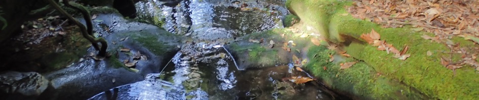
Most of the time the creek was quite pleasant to walk in

Finally we started to drop down into canyon-like sections, what’s the definition of a canyon? It’s deeper than it is wide, so this section qualified.

A little further down, still with the overhang on the right

There were quite often sections of flat rock which were good to walk on.

A surprise for the day, half way down the creek we came across aboriginal sharpening groves in the rock, there were three of them in an area that had water flowing over it. We wondered what food would be down here, plus where would the habitation overhangs be?

You could easily call this the Green Creek, that was the overall feeling – mossy and green.

Another canyon-like section

A huge moss covered tree about 2/3 of the way down the creek (about 1.25k downstream)

And the end of the tree which had obviously been sawn off, why they didn’t take it out is a mystery, maybe it was hollowed out inside.

By now there’s quite a bit of water sitting around (which given the small catchment was a surprise)

Another nice section of creek that was easy going.

Possibly another sharpening grove (but maybe not!)

More canyon-like rock face

The topo map showed a loss of 60m of elevation over 400m but there were a lot of long flat sections.

Chris in a boulder field

Lindsay negotiating down a small waterfall, he managed to stay dry on the steps down, I was soaked by the time I got to the bottom

Lots of bird’s nest ferns on trees and rocks.

Finally we came to a waterfall that we couldn’t go around, and this justified carrying the ropes and our abseil gear all this way. Laurie on the abseil.

Heather coming down the abseil, you can see just below Lindsay there is a tube tape anchor that we discovered after we’d set up the pitch, so, obviously we aren’t the first who thought this might be an abseil canyon/creek!

A waterfall beside our abseil, just beyond the waterfall was a small overhang/cave and it looked as though someone had had a campfire in it.

Another 50 or so metres downstream there’s another small abseil, we possibly could have walked around this one but we had our gear on so what the hell, plus if you look to the left of Laurie you can see that there were a lot of vines and undergrowth to get through.

Lindsay on the abseil

Our lunch spot, this was a two tiered waterfall, and we could have abseiled it but you could walk around it without getting into fallen trees and vines, so it didn’t warrant setting up the rope (would have been a nice abseil though)

Not long after the lunch spot we hit Gap Creek. It was looking really good, easy walking upstream and on the sides, maybe the route up Gap Creek would be ok! (Photo: Laurie A)
This nice flat section didn’t last too long before the creek was full of boulders. So we got out and walked on the lh side, then crossed over to the rh side. We were trying to sidle along above the creek as it was slightly easier going but eventually we were forced back down into the creek to rock hop.
We considered going off track and making a bee-line for the camping/picnic area, but it looked steep and both Laurie and I were interested to see what Gap Creek was like downstream of the waterfall, so we persevered.

Back in the creek, the boulders were huge, here there were only two options, grabbing hold of Laurie’s foot, or chimney-ing up in the bottom rh corner which is what I did.

And then we came to another boulder choke – this one was a little harder for me to get up, even with the rope (Photo: Lindsay B)

Uncharacteristically, Lindsay made getting up the rock (that I had so much trouble with) look easy.
When we got past this last boulder choke, we were at the Waterfall and from there it was a simple walk up the tourist track to the car. Car to car it took us about 6.5 hours, but we took lots of time taking photographs and admiring the creek, so could have been quicker.
Whilst in the side creek, I had thought it would be a good day walk but given the bouldering up Gap Creek, it probably wouldn’t be suitable for anyone but adventurous walkers, definitely not a stroll in the park!

The track log from the day’s exploration. Turned out the waterfall was where we thought it was, the topo map is obviously a little “out” because we were in the creek the whole time but the track log shows us off to the side towards the end.
So, we’ve checked out the first creek, there are a few more possibilities, particularly the creeks that end at the cliff-line. Thanks so much to Laurie, Chris, Lindsay and Heather for joining me!

We had a lot of fun photographing the fungi we saw during the day – and making jokes about fun-guys.

Brilliant tiny red fungi. Lindsay took the pick of the thumbnail at the top of this post.

Weird tree-like fungi at the back of an overhang where it was moist and dark

Weird fluorescent jelly like stuff on this dead tree (about the size of a golf ball), there were 3 or 4 outcrops, but we didn’t find it on other trees (photo: Lindsay B)
Great blog Marilyn, we really liked that trip.
Thanks Laurie, am looking forward to going back and checking out the creeks to the east and west! Next time though will avoid the walk up Gap Creek!
Why did the red mushroom like the white mushroom…..because he was a fun guy!!!
Oh, no, not another fungi joke! Good one though.
What a great trip. Loved the photo of you climbing the boulder!
Yes, that was so funny, unfortunately no-one had the camera out when I was doing the same thing to Laurie!