 On a recent walk to the Mini Western Arthurs in October, we’d walked downstream from our (almost perfect) grassy campsite, to take a look at a spot marked on Oliver’s map with a “C”, denoting “campsite”. We were thwarted by a sheer cliff of about 30m, but peering down, it did look perfect and well worth marking on a map. So, we determined that we’d have to return.
So, who’s Oliver? Well, I’ve mentioned Oliver in other posts, he’s a legend. He and Jim R, were serious walkers in their prime. They went everywhere, but Oliver’s patch (probably in the 70s) was the Wollangambe/Bunglebori area, specifically, between Bunglebori Creek and Wollangambe River. Some time ago he allowed me to copy his topo map and the number of walks that he had done in that area were amazing. He walked in the days when people didn’t have a lot of money and if you were a bushwalker and were going on a 2 week holiday, the norm was to set off with a pack, that doesn’t happen so much these days. He has marked on the map camp caves, water sources and passes – it’s a map that’s priceless (well for me anyway).
I couldn’t see a route on the map associated with the “C” so I called him up and asked him what route he’d taken in, suspecting that it was just a variation of the route that we’d taken in October. It turned out that it wasn’t, he had walked out a similar route to what we’d taken, but the walk in was totally different. However, he mentioned an extremely slippery log that they’d used on their walk to get up the pass, suspecting that all these years later, it would have disappeared, we needed to find this out before we actually did the overnight walk and camped at the “C”! Apart from all else, Oliver’s got to be close to 80, and his memory of the walk was amazing!
So, was the log there, how big was it, how big was the drop up/down – I had visions of a log that was almost vertical!
While we were up at Mt Wilson between Christmas and New Year, Jeff B, Geoff S and I decided that we’d do a day walk to see if we could pin point Oliver’s pass and see if the log was still there to climb up.
 We parked at the Waratah Ridge locked gate (aka Hole in the Wall car park) and headed off along Waratah Ridge. We peeled off onto a ridge (aka Scatters Canyon exit route) that would take us down to the Bunglebori. It was pretty easy going we had to hunt around a little bit for a route through the cliff-line but it wasn’t too hard. We were down in the Bunglebori and at our unnamed creek by lunchtime.
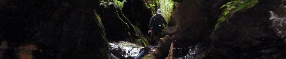
 We headed up, so far, so good, Oliver had said that it was a bit rocky and that it was a small canyon, and that’s what we were in it was about 50m of constricted, canyon and a bit of a tunnel to a waterfall. There was a log, it actually didn’t look that bad, although there was a little snake on it. Geoff wasn’t to be deterred and man-handled a log so that they could get around the snake. I wasn’t going anywhere near that little sucker, so stayed behind “to make sure it didn’t move, and if it did to see where it went” (well, that’s my story and I’m sticking to it).
 The guys got past the snake and went up the slippery log section, they walked a little further along the canyon but were stopped by a waist deep pool. Yes, it was December, and a pool shouldn’t have stopped them, but it was a misty cold day, and after Jeff had one slip and was dunked, I don’t think either of them thought it was a good idea to go further. It seemed too that there wasn’t a way out. Oliver’s description once past the slipper log were ambiguous. So, the guys came back to me (the snake hadn’t moved), and we retraced our steps back to the car.
We figure that we’ll go back for the overnight walk, and walk in to Oliver’s campsite via a fairly obvious path (you can get around that 30m cliff face apparently to get in/out). Then we’ll just go downstream and with more time be able to find our way to the slippery log, it will be much easier going down a small waterfall than it would have been going up. Oh yes, we might go when it’s warmer too, so that if we do get wet it wont be such a big deal and we’ll take lots of tube-tape to use when we’re going down the waterfalls, and just in case there’s another slippery log in this creek worse than the one we found!
Pingback: Arthur’s Canyon – unfinished business | Adventures with M