 NEW ZEALAND – TRAVERS SABINE ROUTE – FEBRUARY 2008
Peter C put this trip on the BWOC calendar and as I’d been on another trip with him to NZ I thought it would be a great opportunity, and he’s so good at organising everything, virtually all I’d have to do is book my flight and turn up on the day! In the end Jeff B, Ross W, Mark M, Rob McC and Viv also signed up which made a great party. We arrived in Christchurch, booked into our accommodation and then went out to buy gas.
 DAY 1: We caught the shuttle bus and were at Blenheim at noon. The bus went via Kaikoura so we got to see the seals at Ohau (which was cool). We then took another Shuttle from Blenheim to St Arnaud, and we left our extra gear with the driver, he’d store it for us until the end of our trip. We set off up track at about 3.00pm with cloudy skies. We walked along the shores of Lake Rotoiti and eventually arrived at Lake Head Hut (620m, 28 bunks & sand flies); 9 km / 3 hours. Thankfully the walk was flat and easy as we all had heavy packs.
DAY 2: Lake Head Hut > John Tait Hut > Upper Travers Hut (about 500m height gain and 18k, 9+ hours). There were rain showers as we walked through mixed beech  forest. We had lunch at John Tait hut and then continued on to Upper Travers Hut and the walking was a little more challenging, now in heavy rain and with rising water levels. There was a great view of Travers Falls, now pumping from the rain we’d had. We passed a person with a strange back pack, it turned out it was a baby carrier with a small toddler in it. Who in their right minds would take a small child out in this weather. Upper Travers is a new hut, and with a warm fire blazing we were very relieved to arrive, it had been a tough day and we were all soaked through!! Fortunately there were two rooms and the family with the small child were in one room and we were in the other. Peter C kept saying how great it was to see someone getting out with their child, all I could think of was what a terrible thing to do to a child, strapped in a pack for 9 hours!
 DAY 3: Upper Travers hut > Travers Saddle > East Sabine footbridge > West Sabine Hut. This day had quite a bit of up and down in it, it was only 8k but took 6+ hours and the day was a bit more challenging. We left the Travers valley, up and over the Travers Saddle, and down into the Sabine valley. We decided to go ahead in ‘iffy’ conditions, and climbed up the 450m to the saddle over rocks and scree, which was cool and misty. We stopped briefly here but moved on for lunch. The views from the saddle were outstanding of the snow capped ranges on either side of the pass. The descent into the Sabine valley of some 940m, seemed to go on for ever and was quite steep down a long scree slope. It was painful on the knees, quads and toes by the bottom. It was a tough day’s walk, but happy hour at West Sabine hut by the river put us all in good spirits.
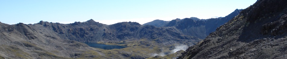
 DAY 4: West Sabine Hut > Blue Lake Hut (assent of about 500m) 7 km / 4 hrs. The walk to Blue Lake was very scenic following the river higher, and we had at last had blue skies in the morning. The first section of the track was like something out of Lord of the Rings, very dim in the forrest with lots of mosses and hanging vines, moss. Further on there were some scree slopes, waterfalls and land slips. Near the hut the track became a little steeper alongside the West Sabine River. We got to the hut in good time, and our spirits were lifted by the sight of the Blue Lake with its fabulous colours and surrounded by rugged and wild peaks. It is truly a very spectacular place. It got cloudy and misty in the afternoon. We went down to admire the Lake and do a little exploring.
DAY 5: At Blue Lake: A chance to take it easy. About 2 km up the Waiu Pass Track was Lake Constance and most of us walked up there, but there was not a lot to see in the cloud and rain. The water  from Lake Constance flows into Blue Lake from a fissure in the wall between the lakes. We spent most of the day in and around the hut as rain and cloud persisted, reading, playing cards and getting ‘hut fever’! Jeff got the Corker Cooker going to keep us all warm and cosy. It rained heavily during the night.
 DAY 6: We retraced our steps from Blue Lake Hut to West Sabine Hut in about 3.5 easy hrs. Early blue sky with snow on the high peaks gave away to steady rain as we headed back down. The creeks were not too high, but we all got wet socks and boots. We spent the afternoon in the hut as it rained persistently. By now we’re all pretty much over New Zealand weather!
DAY 7: West Sabine Hut > Sabine Hut – 13 km / 5/6 hrs; slight descent. Raining lightly at 7 am and we had an easy start at 9 am. It was a fairly leisurely walk to the next hut,  with not so many beech roots and more flat track sections; Peter C saw a trout at last!! Some of us swam in Lake Rotoroa, fought off the sandflies, and rested up for the big day ahead. There was some spectacular country scenery the Sabine gorge and a beautiful sunset, with a bright moon during the night. We all walked out onto the jetty to photograph the sunset.
DAY 8: Sabine Hut > Lake Angelus Hut; 8 km / 7 hrs. We started the climb from the back of Sabine Hut, and steadily climbed 1,100m to Mt Cedric (over about 3k), this was the steepest ascent of the trip. The morning was quite overcast, in fact we set off in cloud which steadily increased the higher we went. Jeff, Ross and I were at the back of the pack and soon lost sight of the advance party but the track was well marked. We reached Mt Cedric although it was difficult to tell in the cloud, we stopped in a sheltered spot and had  some lunch, it was eerie sitting and not being able to see anything because of the cloud. We then continued up another 400m towards Angelus Hut. By now we’re on scree which was really difficult and then narrow ridges. Unfortunately the views were obscured by mist and strong side winds. Then the cloud cleared and we saw Angelus Lake hut in the distance. The area is a truly spectacular series of lakes, tarns and rugged ridges with the Hut on the shores of the main lake. The hut was really, really full but we managed to get a bunk, a lot of people were sleeping on the floor that night (it’s an easy day’s walk in from the road so you get a lot of people just coming here for the night).
 DAY 9: Today was a lay dat at Angelus Hut. Some of us did a 7 hour day walk around the area, all except Ross headed up to Sunset Ridge, and Mark clambered to the top of Mount Angelus [at over 2,000m]. Then Viv ran / climbed to the top of the ridge to the north of the hut – in her Crocs. People started arriving at the hut in the afternoon, thankfully we had already laid our sleeping bags out so that no one could take our spot. When we eventually went to bed, there were bodies everywhere, in the kitchen and on the floor of the dormorory. This hut gets too many people.
DAY 10: Our last day, Angelus Hut > Roberts Ridge > St Arnaud car park, 10 km / 5 hours. Jeff and I got up really early, packed our bags and headed up to watch the sunrise over the mountains – while we had our breakfast. Magic! The hut was so crowded that no sooner had I gotten out of bed, packed up my sleeping bag and started packing but someone had climbed up into the spot where I had slept. It was a mostly sunny day with occasional cloud blocking the views, then the weather cleared and we were rewarded with the some of the best views of the trip:  mountain ranges on both sides, tarns below, the track along the ridge in great view, and the views of Lake Rotoiti and Saint Arnaud. Robert Ridge was a highlight of the walk. We were a day ahead of schedule by the time we got to the car park, but called up the shuttle driver and he came and picked us up, we went straight to Nelson, cleaned up and headed out for a celebratory dinner!
We had a free day in Nelson and then headed home to Australia. This was a GREAT walk, it’s not one of NZ’s Great Walks, but we believe that it’s up there with the best. The water was a bit average but the walk well and truly made up for it.