 BIBBULMUN TRACK, WA – SEPT/OCT 2006
Walpole > Frankland River > Giants > Rame Head > Peaceful Bay > Denmark > Nullaki > West Cape Howe > Shelly Beach > Torbay > Hidden Valley > Albany
John L’E had always wanted to do the Bibbulmun (or parts thereof) and I was a willing convert! We were to stay in “huts” each night, really a wooden 3 sided affair with a roof and a platform to sleep on, you were protected from the elements, but only just.
After the word went out he ended up with a group of 7, John, me, Jim M, Judy D, Michael P, Peter C. and Peter T. We started our journey at 3am in the morning and set off for the airport to catch the 6.15am flight to Perth.
DAY 1: Central Coast – Walpole (4,561k): We then caught a shuttle to the South Perth bus terminal and waited for our bus to Walpole where we eventually arrived at 8pm, we were all stuffed, the highlights of the trip were the driver running over a kangaroo, and the potential disaster that we’d arrive after the one and only grog shop was closed. The driver averted disaster by stopping along the way for us to buy supplies … arrived at the YHA and were able to have a glass of red, a long shower and thankfully sleep.
 DAY 2: Walpole to Frankland River (17.6k): Woke to a rainy type of day, had an early breakfast and then down to the hardware to pick up gas cannisters (which John had thoughtfully pre-arranged). Then, we hit the track, first strolling along the track beside the Walpole Inlet. Eventually we were forced to put on our raincoats, weather had deteriorated. We came to the Giant Tingle tree, was huge and then were soon in sight of the Frankland River Valley and our hut for the night, perched on the banks of the river.
 DAY 3: Frankland River to Giants (13.7k): Another early start, this time 7.15am, walking along the river and beside creek beds. We were still in the red and yellow Tingle forest, we stopped at Sappers Bridge where Peter T had a quick dip to cool off, we weren’t sure if he was starkers or not, no-one dared to look to closely but he did seem a bit furry. Eventually we reached the Tree Tops walk (and civilisation), we did the walk (cost $6) and gorged ourselves on ice creams. It hadn’t been a big day but we were all in bed at Giants Hut by 6pm, someone (also staying in the hut, possibly from WA was heard to remark “first hut I’ve ever been in where everyone was in bed by 6!”)
 DAY 4: Giants to Tame Head (18.9k): Started walking around 7.00am (John is obviously a fan of the early start!). The track goes through the Tingle forest and then descends to and crosses the South Coast Highway onto the old railway alignment for a short distances, then passes a private property (guarded by a woman with big dogs). The wild flowers are starting now to put on a wonderful display, this is mainly what we came for WA is renowned for it’s wild flowers in Sept/Oct. We were now in the sand dunes (and the marker on the beach was missing) so we blundered around for a while in the dunes and scrub before popping out on the top of Conspicuous Cliffs for the fantastic views. Arrived at the hut around 2.30.
 DAY 5: Rame Head to Peaceful Bay (12.4k): Rained all day, strong winds, track descended down from headlands to the coast, walked most of the day along rocky headlands and beaches. Long stretches of pristine beaches and high sand cliffs. Reached Peaceful Bay in the early afternoon (and civilisation), had coffees, chocolate and other goodies in the shelter from the rain. Apparently this tiny hamlet of 60 swells to over 2,500 during holidays. Couldn’t be bothered pitching our tents in the rain so stayed the night in a backpackers out of the rain. By this time Michael had developed blisters so decided not to walk the section to Denmark and hitched a ride with the local break run into Denmark where he sought medical attention, he’d then join us for the rest of the trip to Albany. This proved to be a good decision as he was still unable to rejoin us at Denmark, so blisters really bad.
 DAY 6: Peaceful Bay to Boat Harbour (24k): Left Peaceful Bay at 6am as it was a long day, we had to cross a river via canoe, this added an hour to our journey. Crossing the river was interesting as we had to make several trips! The wild flowers on this section were spectacular. Got into Boat Harbour around 4pm and were happy to finish for the day.
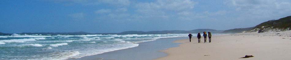
 DAY 7: Boat Harbour to William Bay (21.6k): Up early to walk in the cool of the day and walked along a ridge next to the coast. Dropped down to Parry Inlet where there’s a good camp ground and van park. Bludged some fresh rain water from the caretaker and walked down onto the beach and then walked 7k along the beach to our next night’s shelter. The seas weren’t too rough now and we were able to have some swims in the ocean.
 DAY 8: William Bay to Denmark (20.9k): A mix of beach walking and back in the dunes, then we came to farmland (where we used a stile to cross fencing), crossing this to get to the highway. We then climbed to Monkey Rock (great views of Parry’s Inlet) and continued to climb up Mt Halliwell (more great views). Then it was 2k all downhill back to the highway and 7k on cycle ways into town. By this time it’s very hot and we’re all tired, the last 2k was horrendous with the only thing keeping us going was the thought of a beer at the pub. Finally reached the pub at 3.45pm, many bears later, 3 plates of chips/wedges (despite Judy saying we’d never get through them). Met up with Michael at the YHA good to have a good shower and change clothes. A big day, managed to stay up until 8pm!
DAY 9: Denmark R&R (ok): caught up in washing so we had clean clothes for the next week. Ate heaps, drank too much, slept a lot!

 DAY 10: Denmark to Nullaki (2k): We had decisions to make to get to the south side of Wilson inlet. We had 3 options: (1) the sandbar across the inlet had been breached and the water was flowing too fast so that was a no go (2) today’s wind stopped the boat across the inlet so that was a no go (3) hitch a ride on the bus and save the 25k road walk, that met with unanimous approval! So, we had a long 30m walk to the Nullaki camp site arriving at 11.30am and spent the rest of the day veg-ing out!
DAY 11: Nullaki to West Cape Howe (17k): Not a cloud in the sky, perfect weather, we started at 6.30am and arrived at 1.10pm. Great walking, flowers not as spectacular as previously but still good. Occasional views and we had a swim at Lowlands Beach in the crystal clear water with not a soul in sight. Scrub hemmed us in after lunch and it started to heat up, numerous stops in the heat. No snake alarms but a couple of mating shingle backs were spotted. Thankful to arrive at the hut to get out of the heat!
DAY 12: West Cape Howe to Shelly Beach (12k): Hot day and early start at 6.40, arriving at the hut at 11.30, we had a creek not 50m from the hut and so we spent the day relaxing, swimming and getting sunburned. All agreed that Shelly was a “must return to someday” sort of hut.
DAY 13: Shelly Beach to Torbay (5.6k): Started raining at 7.30, we sprinted to Torbay hut arriving at 8.30 (that’s fast walking), but the weather was abysmal. Once in the hut we warmed up in our sleeping bags and spent the rest of the day eating, sleeping and drinking tea to the sound of torrential rain. I found a book in a box (where the log book was) and started to read it, was pretty good but got to a section which obviously was pretty risqué and discovered that some puritan had ripped the pages out! A couple of guys joined us mid afternoon and cooked up a meal of bacon, mushrooms and onions, we were all salivating. Then when getting into bed one of the guys fell on Judy (intentionally?), we were all in bed by 6pm, much snoring and other sounds during the night.
 DAY 14: Torbay to Hidden Valley (17.1k): Left at 6.30am with overcast sky which eventually cleared. Beautiful ocean and island views and we descended steps to the beach and began our 7k walk along the shoreline (hard going). We had to cross Torbay Inlet, water level was a bit higher than expected, so we all stripped down to undies and t-shirts and braved the freezing water. Left the beach as it began to rain, then into the bush. Reached the hut at midday and enjoyed great views back along the coastline and the wind farms above the cliffs.
 DAY 15: Hidden Valley to Albany (19.5k): Our last day! and this part of the walk was spectacular, walking along ocean cliff tops next to the wind farm (that in itself was interesting, quite noisy) with vistas to the east and west. We took a short cut which involved a small road bash, as all of were looking forward to real food. Last few hours were spent walking through the suburbs of Albany to the visitor information hut which is the official end of the track. We celebrated the walk with a visit to the Earl of Spencer (recommended by the guys at Torbay hut), the pies were delicious and much beer was consumed.
This was a great walk and a real adventure. Lessons learned: there’s no such thing as quick dry knickers; and don’t unwrap sticky lollies to save on rubbish on the track as they all then stick together! Thanks John for a great experience!
What an awesome walk, loved the photos…will do this one one day.
Yes, now that a bit of time has gone by, I’d do it again, might even consider doing the whole 6 weeks of it, the full trip! Now that would be epic.